Image characteristic registration based geometrical fine correction method for aviation multispectral remote sensing image

A multi-spectral image and remote sensing image technology, applied in the field of remote sensing, can solve problems such as incomplete fine correction

Inactive Publication Date: 2012-07-25
SECOND INST OF OCEANOGRAPHY MNR
View PDF2 Cites 33 Cited by
  • Summary
  • Abstract
  • Description
  • Claims
  • Application Information

AI Technical Summary

Problems solved by technology

This method basically eliminates the tangent distortion, and the

Method used


Image

  • Image characteristic registration based geometrical fine correction method for aviation multispectral remote sensing image
  • Image characteristic registration based geometrical fine correction method for aviation multispectral remote sensing image
  • Image characteristic registration based geometrical fine correction method for aviation multispectral remote sensing image

Examples


Embodiment Construction

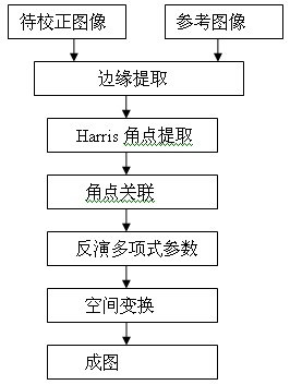
[0069] The steps of the precise geometric correction method for aerial multi-spectral remote sensing images based on image feature registration can be found in the appendix figure 1 ,as follows:

[0070] 1) The aerial multispectral remote sensing image to be registered and the standard orthographic high-resolution satellite image are extracted using Sobel edge detection operator;

[0071] 2) Use the Harris corner detection method to detect the corner points of the aerial multispectral image to be registered and the standard orthographic high-resolution satellite image;

[0072] 3) Coarse correlation between the aerial multispectral image to be registered and the corner points of the standard ortho-resolution satellite image is carried out by the correlation method;

[0073] 4) Carry out fine association between two image corners by calculating support strength;

[0074] 5) Back-calculate the polynomial coefficients according to the polynomial model;

[0075] 6) Using biline...


PUM


Abstract

The invention discloses an image characteristic registration based geometrical fine correction method for an aviation multispectral remote sensing image, comprising following steps of: 1) utilizing a Sobel edge detection operator to carry out edge extraction on both an aviation multispectral remote sensing image to be registered and a normal incidence high-resolution satellite image which is taken as a standard; 2) utilizing a Harris angular point detection method to detect angular points of the aviation multispectral remote sensing image to be registered and the normal incidence high-resolution satellite image which is taken as the standard; 3) carrying out rough correlation between the two images through a correlation method; 4) carrying out fine correlation between the angular points of the two images through calculating supporting strength; 5) carrying out back calculation to obtain a multinomial coefficient according to a multinomial model; and 6) carrying out gray level re-sampling by adopting a bilinear interpolation to obtain a registered image. According to the image characteristic registration based geometrical fine correction method for the aviation multispectral remote sensing image, disclosed by the invention, the geometrical correction problem of the aviation multispectral remote sensing image lacking of a ground reference point can be better solved and the geometrical correction precision of an aviation multispectral scanner is improved, so that an aviation remote sensing technology can be better applied to production livings of national economy.

Description

technical field [0001] The invention relates to the technical field of remote sensing, in particular to a method for precise geometric correction of aerial multispectral remote sensing images based on image feature registration. Background technique [0002] In aerial remote sensing, due to the complex air flow and large fluctuations on the sea surface, the flight attitude of the aircraft is easily affected, which makes the imaging attitude of the airborne multispectral remote sensing scanner unstable and the geometric distortion of the image is serious. Geometric correction must be performed before data application. However, some multispectral remote sensing scanners do not have attitude angle measurement devices such as IMU / POS (Inertial Measurement Unit / Position and Orientation Solutions), which poses a great challenge to geometric correction. The invention is a geometric precision correction method of aerial multispectral remote sensing images based on image feature regi...

Claims


Application Information

Patent Timeline
IPC IPC(8): G06T5/00G06T7/00
Inventor 王迪峰潘德炉沈亮毛志华龚芳
Owner SECOND INST OF OCEANOGRAPHY MNR
Why Eureka
Try Eureka