Navigation multiple spectrum scanner geometric approximate correction method under non gesture information condition

A technology of rough geometric correction and attitude information, which is applied in the field of remote sensing

Inactive Publication Date: 2008-01-30
SECOND INST OF OCEANOGRAPHY MNR
View PDF0 Cites 24 Cited by
  • Summary
  • Abstract
  • Description
  • Claims
  • Application Information

AI Technical Summary

Problems solved by technology

Xiong Zhen et al. corrected the course of OMIS images without using control points and attitude values, but the accuracy still needs to be further improved [4]

Method used


Image

  • Navigation multiple spectrum scanner geometric approximate correction method under non gesture information condition
  • Navigation multiple spectrum scanner geometric approximate correction method under non gesture information condition
  • Navigation multiple spectrum scanner geometric approximate correction method under non gesture information condition

Examples


Embodiment Construction

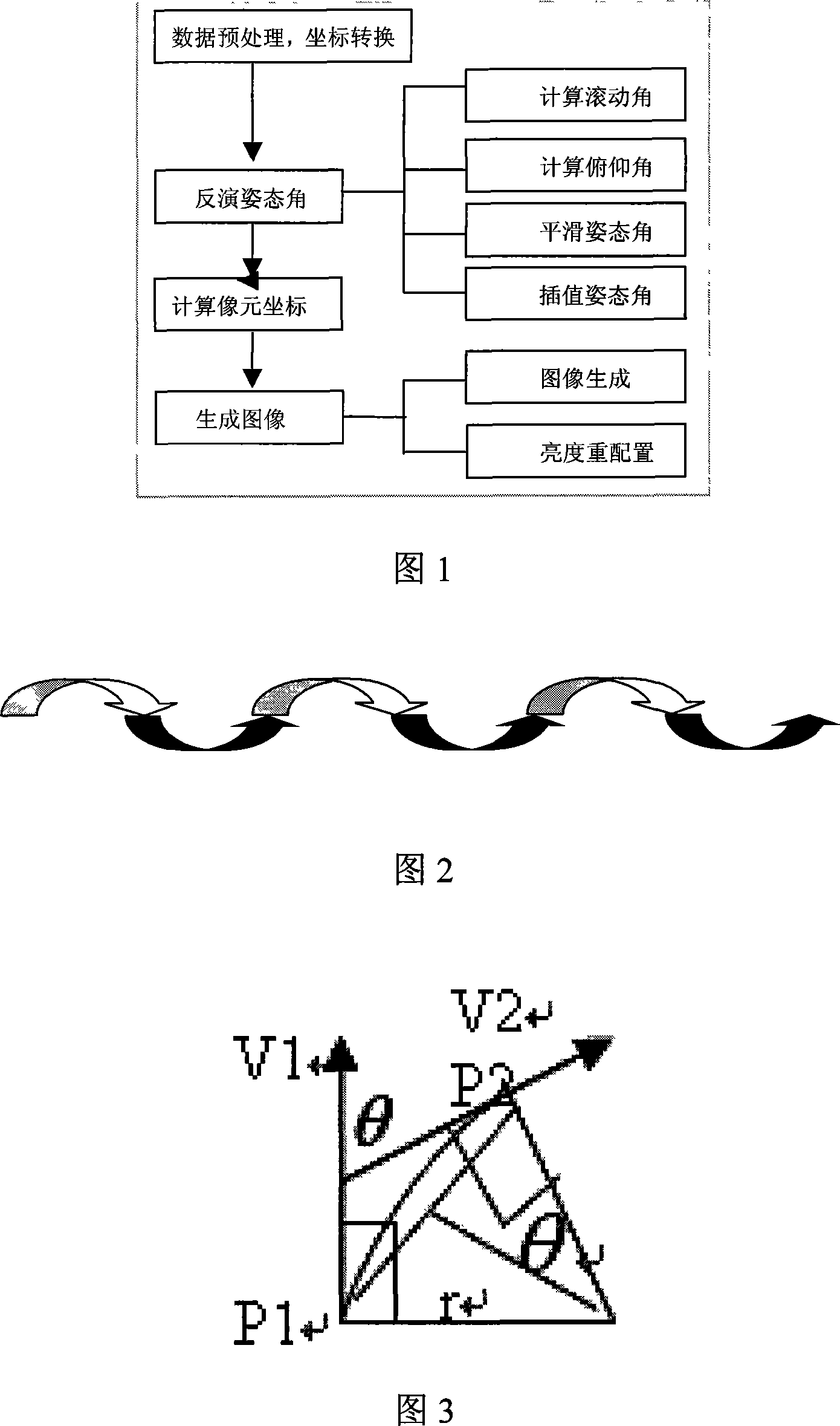
[0069] The rough geometric correction method of aerial multi-spectral scanner under the condition of no attitude information includes the following steps:

[0070] 1) Perform coordinate conversion on the data of the multispectral scanner, and convert the measured observation value in the WGS-84 geodetic coordinate system to the value in Gaussian plane rectangular coordinates, which is beneficial to the application of remote sensing inversion after correction;

[0071] 2) According to the ideal flight model, use the 1-second mode to simulate the roll angle;

[0072] 3) Fit the aircraft pitch angle according to the altitude data, that is, fit a curve in the vertical plane according to the altitude data, and then calculate the flight pitch angle at each updated data point according to the tangent of the curve;

[0073] 4) Use the central projection constellation equation to obtain the coordinates of the off-camera point;

[0074] 5) Obtain the coordinates of other points on the same ...


PUM


Abstract

The invention discloses an avigation multi-spectral scanner geometric rough correction method under the conditions of no gesture information, which comprises the steps that: 1) the multi-spectral scanner data is carried out the coordinate conversion, the measured value in a WGS-84 ground coordinate system is converted to the value in a Gaussian plane Cartesian coordinate; 2) according to a ideal flight model, an one second mode is used for simulating a rolling angle; 3) a curve is fitted according to the height data in the vertical plane, then the flight pitching angle in each updated data point is calculated according to the cutting direction; 4) the central projection constitutive equation is used for obtaining the point coordinates; 5)according to the flight height, the scanning angel and the instantaneous scanning angel, the other points coordinates in the same scanning row are obtained by the scanning mode; 6) a direct method is used for producing a rough correction image. The invention improves the geographical accuracy of the avigation remote sensing, and is an innovation of the remote sensing technology under the conditions of no gesture information and improves the time effectiveness, so the avigation remote sensing technology can be better applied to the production and livelihood of the national economy.

Description

Technical field [0001] The invention relates to the technical field of remote sensing, in particular to a method for rough geometric correction of an aerial multi-spectral scanner under the condition of no attitude information. Background technique [0002] Since the 1960s, the study of geometric characteristics of airborne multi-spectral scanning images has always been a concern. Under the condition of no posture information, the traditional geometric correction method only uses the control points and the least squares method to fit the space conversion polynomial, and the corrected image is obtained by interpolation. This method requires a lot of manpower to select control points, and the accuracy is limited by subjective and objective factors. What's more important is that this method can only eliminate the overall distortion of the image to a certain extent in a limited sub-region, but cannot eliminate the high-frequency distortion caused by the platform posture and movement ...

Claims


Application Information

Patent Timeline
Patent Type & Authority Applications(China)
IPC IPC(8): G01S17/89G01S7/497G01B11/03G01B21/04G01B21/20
Inventor 王迪峰潘德炉刘涛
Owner SECOND INST OF OCEANOGRAPHY MNR
Why Eureka
Try Eureka