Channel length calculating method and channel length calculating device
A channel length and calculation method technology, applied in the field of geographic information, can solve problems such as inaccurate channel length calculations, achieve the effects of reducing channel projection errors, improving calculation accuracy, and solving large channel deformation errors
- Summary
- Abstract
- Description
- Claims
- Application Information
AI Technical Summary
Problems solved by technology
Method used
Image

Examples
Embodiment 1
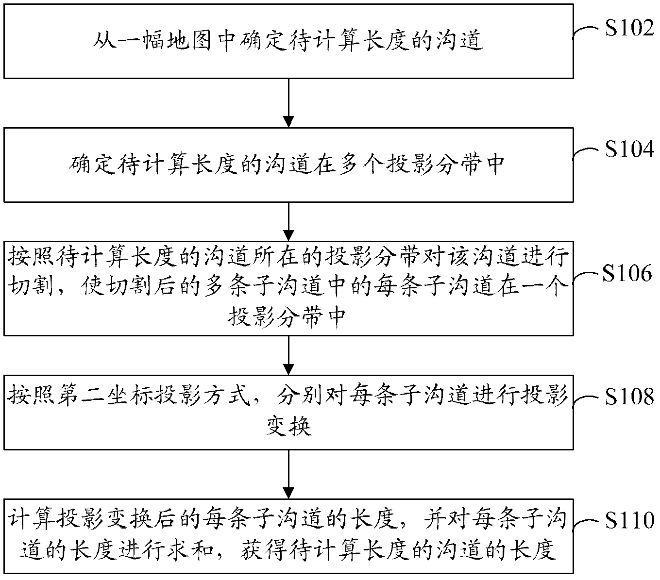
[0025] refer to figure 2 , shows a flow chart of steps of a channel length calculation method according to Embodiment 1 of the present application.
[0026] The channel length calculation method of this embodiment includes the following steps:
[0027] Step S102: Determine the channel whose length is to be calculated from a map.
[0028] Wherein, the one map includes multiple tiled maps spliced by the first coordinate projection method.
[0029] Because when the tiled map is spliced into one under the projection method adopted by itself, the boundary cannot be spliced perfectly. For this reason, projection methods other than the framed map projection method are often used for splicing, so that the boundary splicing is intact, but this further increases the deformation error caused by the projection, making the calculation of the channel length inaccurate.
[0030] Step S104: Determine that the channel whose length is to be calculated is in multiple projection sub-ban...
Embodiment 2
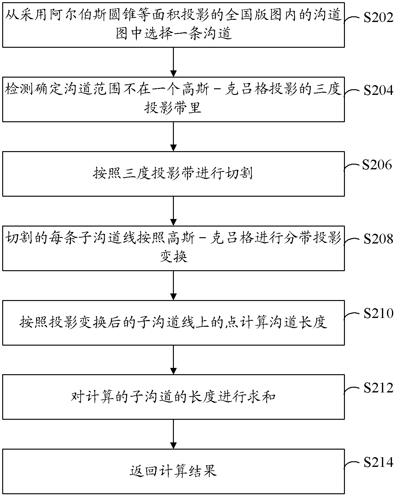
[0041] refer to image 3, shows a flow chart of steps of a channel length calculation method according to Embodiment 2 of the present application.
[0042] In this embodiment, the basic data is the channel map in the national territory using the Albers conic equal-area projection. That is to say, this embodiment is aimed at the calculation of the channel length in one map of the whole country, that is, the calculation of the channel length in which the whole country is spliced into one map from multiple tiled maps. Among them, the tiled map itself adopts the high-level-Krüger projection. In order to make the boundary stitching intact, the tiled map is stitched into a national map using the Albers projection. In order to make the calculation of the channel length more accurate and the effect better, the projection banding in this embodiment adopts the three-degree band of Gauss-Krüger. However, those skilled in the art should understand that the above-mentioned projection m...
Embodiment 3
[0059] refer to Figure 4 , shows a structural block diagram of a channel length calculation device according to Embodiment 3 of the present application.
[0060] The channel length calculation device in this embodiment includes: a determination module 302, configured to determine the channel whose length is to be calculated from a map, wherein the map includes multiple frames spliced by the first coordinate projection method map; segmentation module 304, configured to determine that the channel is in a plurality of projection zones, and the projection zone is the projection zone in the second coordinate projection mode adopted by the framed map; according to where the channel is located Cutting the channel by projection sub-banding, so that each sub-channel in the multiple sub-channels after cutting is in one projection sub-band; the transformation module 306 is used to, according to the second coordinate projection method, separately transform each sub-channel Perform pro...
PUM
 Abstract
Description
Claims
Application Information
 - Generate Ideas
- Intellectual Property
- Life Sciences
- Materials
- Tech Scout
- Unparalleled Data Quality
- Higher Quality Content
- 60% Fewer Hallucinations
Browse by: Latest US Patents, China's latest patents, Technical Efficacy Thesaurus, Application Domain, Technology Topic, Popular Technical Reports.
© 2025 PatSnap. All rights reserved.Legal|Privacy policy|Modern Slavery Act Transparency Statement|Sitemap|About US| Contact US: help@patsnap.com