Method for positioning underwater wireless sensor network

A wireless sensor and positioning method technology, applied in positioning, network topology, wireless communication, etc., can solve the problems of not considering the distance of beacon nodes, and the inability to recognize the positioning value of beacon nodes, etc.

Inactive Publication Date: 2012-08-01
NANJING UNIV OF POSTS & TELECOMM
View PDF3 Cites 18 Cited by
  • Summary
  • Abstract
  • Description
  • Claims
  • Application Information

AI Technical Summary

Problems solved by technology

APIT is simple to execute and does not have a high additional communication load, but because it does not consider the distance between the beacon node and the

Method used


Image

  • Method for positioning underwater wireless sensor network
  • Method for positioning underwater wireless sensor network
  • Method for positioning underwater wireless sensor network

Examples


Embodiment Construction

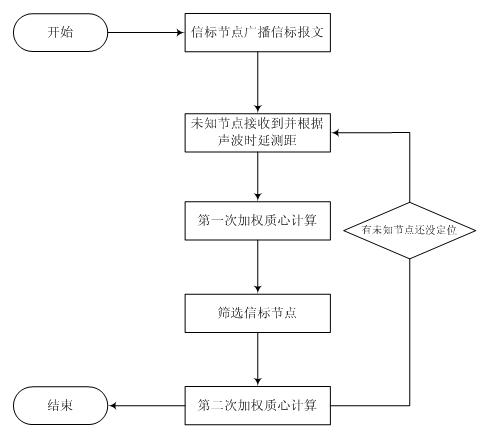
[0043] Below in conjunction with accompanying drawing, the technical scheme of invention is described in detail:

[0044] Such as figure 1 Shown: the present invention proposes a kind of underwater wireless sensor network positioning method comprising the following steps:

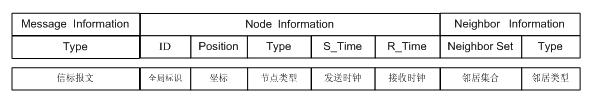
[0045] Step 1, the beacon node sends the beacon message with the maximum transmission power, the structure of the beacon message is as follows figure 2 Shown: Contains information such as global identifier, coordinates, node type, sending clock, receiving clock, neighbor set, neighbor type, etc.;

[0046] Step 2: Measure the distance between the beacon node and the unknown node, specifically including the following steps:

[0047] Step 2-1: The unknown node monitors and receives the beacon message sent by the beacon node, and obtains the message clock sent by the beacon node;

[0048] Step 2-2: According to the time difference between the clock when the unknown node receives the message and the clock wh...


PUM


Abstract

The invention relates to a method for positioning an underwater wireless sensor network, which belongs to the technical field of wireless sensor network positioning. The method includes: obtaining a primary estimation coordinate of an unknown node by means of primary weighted centroid algorithm according to a measured distance between a beacon node and the unknown node; and setting the weightiness according to the distance value to select a plurality of proper beacon nodes to obtain a secondary estimation coordinate of the unknown node by means of secondary weighted centroid algorithm, and finally determining the coordinate of the unknown node. The method is low in calculation complexity, positioning accuracy is improved, estimation errors are reduced, and the method is applicable to positioning of underwater wireless sensor networks.

Description

technical field [0001] The invention relates to a positioning method for an underwater wireless sensor network, belonging to the technical field of wireless sensor network positioning. Background technique [0002] Initially, the research on WSN positioning algorithms focused on infrastructure-based positioning technologies. Typical research results include Active Badge, Active Bat, and RADAR. Since then, the focus of research has shifted to ad hoc infrastructure-free positioning technology, which has become the mainstream research direction of WSN positioning algorithms. [0003] A centroid location algorithm based on network connectivity proposed by Nirupama Bulusu et al. In this algorithm, a beacon node periodically broadcasts a beacon packet containing its own ID and location information. If the number of received packets of an unknown node exceeds a preset threshold or the receiving time exceeds a set time limit, the node’s location It is regarded as the centroid of t...

Claims


Application Information

Patent Timeline
IPC IPC(8): G01S5/00H04W84/18
Inventor 刘林峰吴家皋
Owner NANJING UNIV OF POSTS & TELECOMM
Why Eureka
Try Eureka