System and method for realizing GPS (Global Positioning System) time correction and parameter management in prospecting instrument

A technology of GPS time and exploration instruments, applied in the field of field detection, can solve the problems of cumbersome methods and inconvenient field work, and achieve the effects of simplifying the field operation process, saving time, and reducing equipment management and maintenance work

Inactive Publication Date: 2012-08-15
CHONGQING GEOLOGICAL INSTR FACTORY
View PDF1 Cites 0 Cited by
  • Summary
  • Abstract
  • Description
  • Claims
  • Application Information

AI Technical Summary

Problems solved by technology

[0005] In view of this, the present invention provides a method and system for GPS time calibration and parameter management in exploration instruments to solve the problem that the existing methods are cumbersome and bring inconvenience to field work

Method used


Image

  • System and method for realizing GPS (Global Positioning System) time correction and parameter management in prospecting instrument
  • System and method for realizing GPS (Global Positioning System) time correction and parameter management in prospecting instrument
  • System and method for realizing GPS (Global Positioning System) time correction and parameter management in prospecting instrument

Examples


Embodiment Construction

[0024] The following will clearly and completely describe the technical solutions in the embodiments of the present invention with reference to the accompanying drawings in the embodiments of the present invention. Obviously, the described embodiments are only some, not all, embodiments of the present invention. Based on the embodiments of the present invention, all other embodiments obtained by persons of ordinary skill in the art without making creative efforts belong to the protection scope of the present invention.

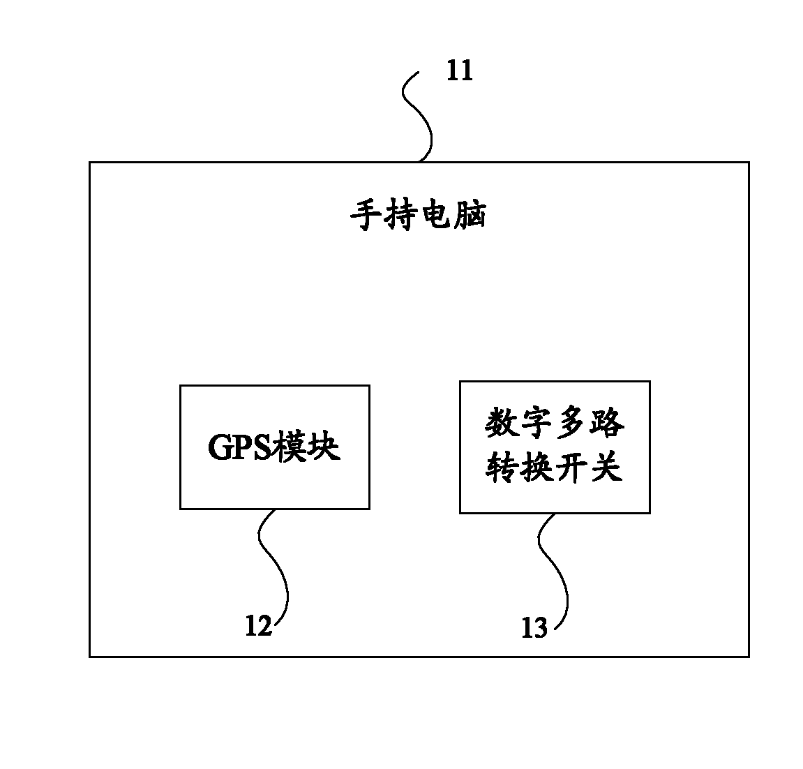
[0025] The embodiment of the present invention provides a system for realizing GPS time calibration and parameter management in exploration instruments, figure 1 It is a structural diagram of the system. The system provided by the embodiment of the present invention includes: a handheld computer 11 , a GPS module 12 and a digital multiplexer switch 13 .

[0026] The GPS module 12 and the digital multiplex switch 13 are arranged inside the handheld computer 11 ...


PUM


Abstract

The invention provides a system for realizing GPS (Global Positioning System) time correction and parameter management in a prospecting instrument, comprising a handheld computer, a GPS module and a digital multi-path change-over switch, wherein the GPS module and the digital multi-path change-over switch are arranged inside the handheld computer; the digital multi-path change-over switch is used for receiving a change-over control signal; and the communication of the prospecting instrument is changed over between the GPS module and the handheld computer. The invention further provides a method for realizing the GPS time correction and the parameter management in the prospecting instrument. The method and the system disclosed by the invention can realize the change-over of the communication between the prospecting instrument and the GPS, and between the prospecting instrument and the handheld computer through controlling the digital multi-path change-over switch; and therefore, a wild operation process is greatly simplified and the time is saved. Furthermore, the GPS is placed into the handheld computer, and the GPS and the handheld computer are combined to form a whole body, so as to greatly reduce management and maintenance work of equipment.

Description

technical field [0001] The invention relates to the technical field of field detection, in particular to a system and method for realizing GPS time correction and parameter management in exploration instruments. Background technique [0002] At present, field exploration instruments at home and abroad complete the time calibration and the insertion of geographic information by connecting to GPS, and complete the insertion of management parameters by connecting to handheld computers such as PDAs. [0003] Usually, exploration instruments can only be connected to one of GPS and handheld computers at a certain time. When time calibration and geographic information insertion are required, GPS needs to be connected to establish a connection between the exploration instrument and GPS. When it is necessary to manage When inserting the parameters, first remove the GPS, disconnect the connection with the exploration instrument, and then connect the handheld computer to establish the ...

Claims


Application Information

Patent Timeline
Patent Type & Authority Applications(China)
IPC IPC(8): G01V13/00
Inventor 王桂梅刘永川
Owner CHONGQING GEOLOGICAL INSTR FACTORY
Why Eureka
Try Eureka