Method for calculating mean free path (MFP) of exploration rover against complex terrain environment

A complex terrain and detector technology, applied in the aerospace field, can solve the problems of not considering the mobility performance of obstacle-crossing ability, neglecting the verification of climbing ability, etc., so as to reduce the algorithm complexity and improve the simulation speed.

Inactive Publication Date: 2012-08-22
DALIAN UNIV OF TECH
View PDF2 Cites 3 Cited by
  • Summary
  • Abstract
  • Description
  • Claims
  • Application Information

AI Technical Summary

Problems solved by technology

[0005] In practical applications, due to the complex surface environment of stars, the existing mean free path calculation formulas have the following defects: only consider the situation that there are only circular obstacles in the flat terrain, if the rocks, pits, etc. Obstacles that hinder the roaming of the patrol detector are simplified as circular obstacles with a certain diameter, which i

Method used


Image

  • Method for calculating mean free path (MFP) of exploration rover against complex terrain environment
  • Method for calculating mean free path (MFP) of exploration rover against complex terrain environment
  • Method for calculating mean free path (MFP) of exploration rover against complex terrain environment

Examples


Embodiment Construction

[0042] The present invention will be further described below in combination with technical solutions and accompanying drawings. The size of the inspection detector in this embodiment is 1.5m in length, b=1.0m in width, the slope θ is limited to 20°, and the obstacle-crossing capability (vertical direction) h is 20cm.

[0043] A. Selection of patrol detector positioning point and driving direction

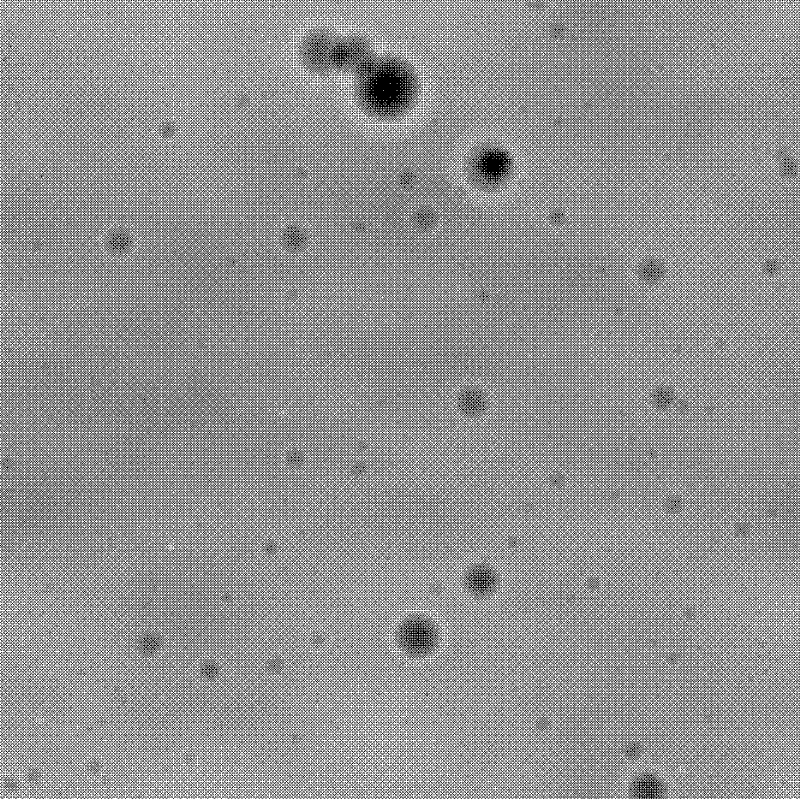
[0044] The first step is to take a piece of 60*60m in the Apollo 15 landing area on the lunar surface 2Taking the topographic data as an example, if the spatial distance represented by each pixel is selected as 60mm, it can be established figure 1 The 1000*1000 resolution star terrain digital elevation map DEM shown, the minimum elevation value Z of this area min -1.7m, the maximum elevation value Z max It is 1.45m, which corresponds to the gray level of 0-255 in the digital elevation map DEM, that is, each gray level represents a ground height of 12.35mm.

[0045] In the secon...


PUM


Abstract

The invention discloses a method for calculating a mean free path (MFP) of an exploration rover against complex terrain environment, which comprises selecting a locating point and a running direction of the exploration rover; judging passibility of a projection region of the exploration rover body; and calculating the MFP. The invention really reflects the exploration environment of the exploration rover by establishing a digital elevation map (DEM) of star terrain, and can be applied to complex terrain environment having various obstacles (such as slopes and irregular obstacles), and the calculation accuracy is not affected by the complex degree of terrain. The invention calculates the MFP by rotating the DEM of the star terrain at a fixed angle interval and straightly moving along the fixed direction on each map, simplifies the algorithm complicacy, and simultaneously improves the simulation rate. The method adopts the slope and elevation difference as a termination judgment condition of a single MFP calculation, and comprehensively considers climbing capacity and obstacle clearance capacity of the exploration rover.

Description

technical field [0001] The invention belongs to the field of aerospace, and relates to a method for calculating the mean free path of a patrol detector, in particular to a method for calculating the mean free path of a patrol detector aimed at complex terrain. Background technique [0002] Launching patrol probes to extraterrestrial bodies such as the moon and Mars is a key link in the field of deep space exploration. The mean free path (Mean Free Path, MFP) is a statistical measure related to the probability of the patrol detector encountering obstacles and the ability to pass obstacles. It is defined as: in a specific terrain, before the direction of travel must be changed, the patrol The average distance that the detector can travel in a straight line. Its main purpose has the following two aspects: (1) Evaluate the mobile performance of the patrol detector under specific terrain, and provide the basis for the size selection, suspension design and chassis design of the p...

Claims


Application Information

Patent Timeline
IPC IPC(8): G06F19/00
Inventor 李琳辉连静王蒙蒙韩虎郭烈王文波
Owner DALIAN UNIV OF TECH
Why Eureka
Try Eureka