Visual-inertial combined navigation method

A technology of inertial combination and navigation method, applied in the field of navigation, can solve the problems of limited spatial resolution of imaging system, poor image matching accuracy of visual navigation method, calibration error of measurement system, etc., achieve autonomous flight capability, improve correction effect, improve The effect of navigation accuracy

Active Publication Date: 2012-11-07
TSINGHUA UNIV
View PDF5 Cites 50 Cited by
  • Summary
  • Abstract
  • Description
  • Claims
  • Application Information

AI Technical Summary

Problems solved by technology

However, the visual navigation method mainly has the shortcomings of poor image matching accuracy, error in the positioning of image points in the t

Method used


Image

  • Visual-inertial combined navigation method

Examples


Embodiment Construction

[0021] The embodiments of the present invention are described in detail below. Examples of the embodiments are shown in the accompanying drawings, in which the same or similar reference numerals indicate the same or similar elements or elements with the same or similar functions. The embodiments described below with reference to the drawings are exemplary, and are only used to explain the present invention, but should not be understood as limiting the present invention. On the contrary, the embodiments of the present invention include all changes, modifications and equivalents falling within the scope of the spirit and connotation of the appended claims.

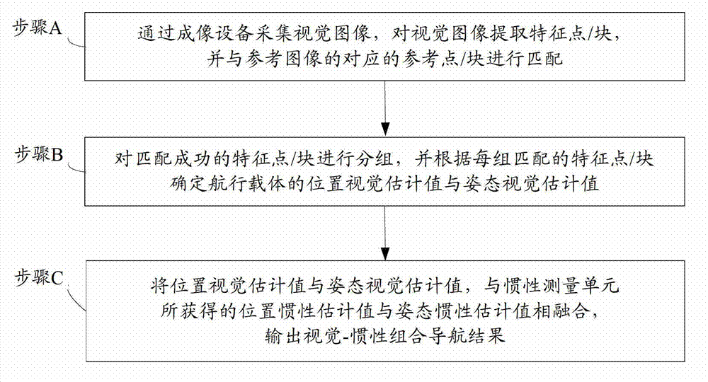
[0022] The following reference is attached figure 1 A visual-inertial integrated navigation method according to an embodiment of the present invention is described. Such as figure 1 As shown, the visual-inertial integrated navigation method includes the following steps:

[0023] Step A: Collecting a visual image by the imaging...


PUM


Abstract

The invention provides a visual-inertial combined navigation method, which comprises the following steps of: acquiring a visual image through imaging equipment, extracting feature points/ blocks from the visual image, and matching with corresponding reference points/ blocks of a reference image; grouping the feature points/ blocks succeeding in matching, and determining a position visual estimation value and a posture visual estimation value of a navigation carrier according to each group of matched feature points/ blocks; and fusing the position visual estimation value, the posture visual estimation value and a position inertial estimation value and a posture inertial estimation value which are acquired by an inertial measurement unit, and outputting a visual-inertial combined navigation result. According to the visual-inertial combined navigation method of the embodiment, errors of an inertial navigation system are corrected by using a visual navigation technology, so that the navigation precision is improved, and autonomous flight capability of the navigation carrier is realized.

Description

Technical field [0001] The invention relates to the field of navigation, in particular to a visual-inertial integrated navigation method. Background technique [0002] The process of guiding the navigation vehicle from the starting point to the destination is called navigation. There are many technical approaches to navigation, such as radio navigation, celestial navigation, satellite navigation, infrared navigation, inertial navigation, and visual navigation. [0003] Among them, inertial navigation uses accelerometers and gyroscopes to calculate the voyage, infer the current position and the next destination, and has strong autonomy and is not susceptible to interference. It is the main navigation method at present. However, the inertial navigation system (Inertial Navigation System, INS) cannot fully meet the needs of practical applications due to its inherent accumulation of navigation errors, the navigation accuracy decreases with time, and the equipment cost is high. [0004]...

Claims


Application Information

Patent Timeline
IPC IPC(8): G01C21/16G01C21/00
Inventor 戴琼海刘宇驰
Owner TSINGHUA UNIV
Why Eureka
Try Eureka