
Electromagnetic data terrain correction method

An electromagnetic data and terrain correction technology, applied in the field of geophysical exploration, can solve problems such as poor results, limited number of data points, and differences, and achieve the effect of improving capacity and processing efficiency and improving results

Active Publication Date: 2012-11-14
BC P INC CHINA NAT PETROLEUM CORP +1
View PDF2 Cites 19 Cited by
  • Summary
  • Abstract
  • Description
  • Claims
  • Application Information

AI Technical Summary

Problems solved by technology

[0008] The traditional ratio method has a certain effect on suppressing the terrain influence, but the apparent resistivity distribution after using the ratio method to correct the terrain influence is still different from the result of the horizontal terrain model, and its residual part is in a mirror image relationship with the terrain
Moreover, most of these methods focus on the theoretical simulation of indoor simple terrain, and there are few reports on terrain correction for large-scale measured data.
[0009] Due to the consumption of a large amount of computer memory resources when simulating terrain, the number of processed data points is limited, and it cannot meet the actual measurement data requirements of long electromagnetic profiles.
The effect of the traditional ratio method on electromagnetic data terrain correction is not good

Method used


Image

  • Electromagnetic data terrain correction method
  • Electromagnetic data terrain correction method
  • Electromagnetic data terrain correction method

Examples


Embodiment Construction

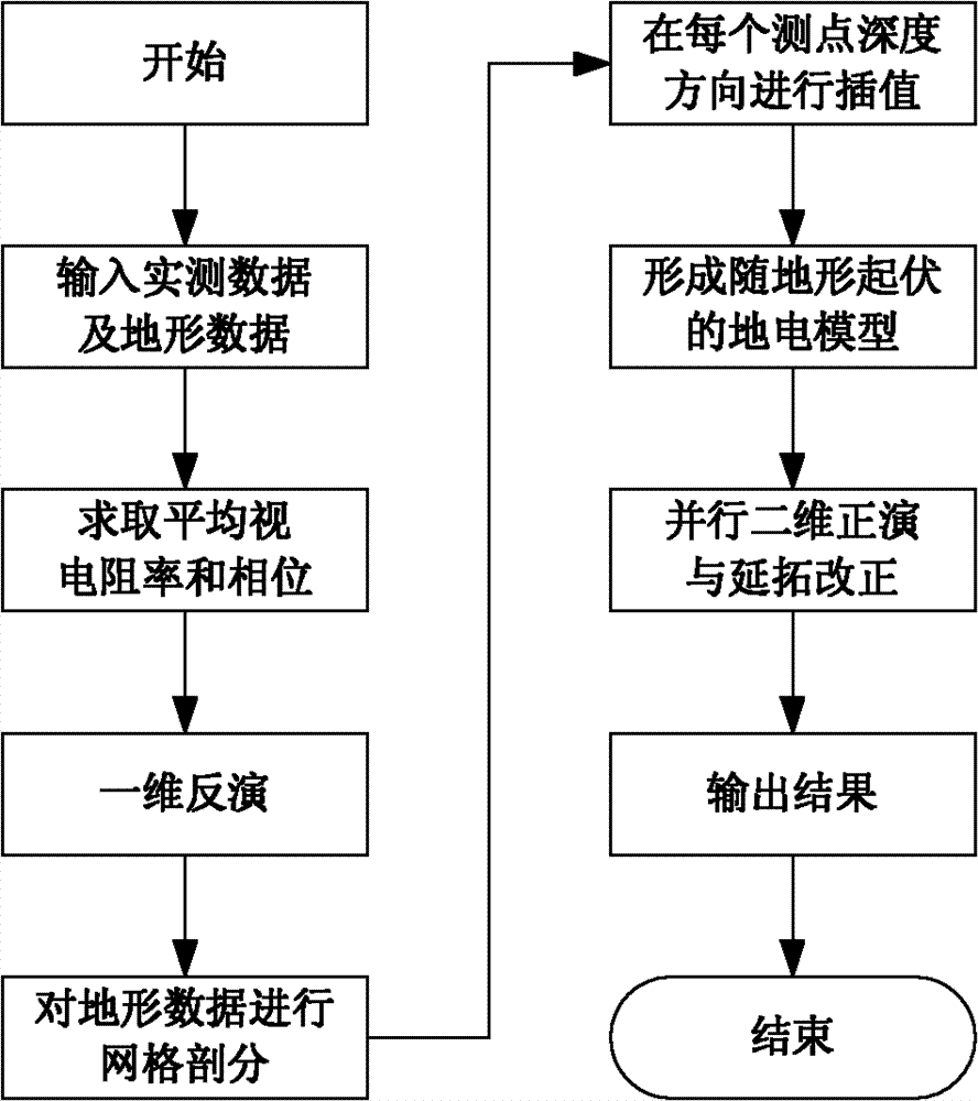
[0036] The following is an example of terrain correction for two-dimensional continuous magnetotelluric profiling (CEMP) data.

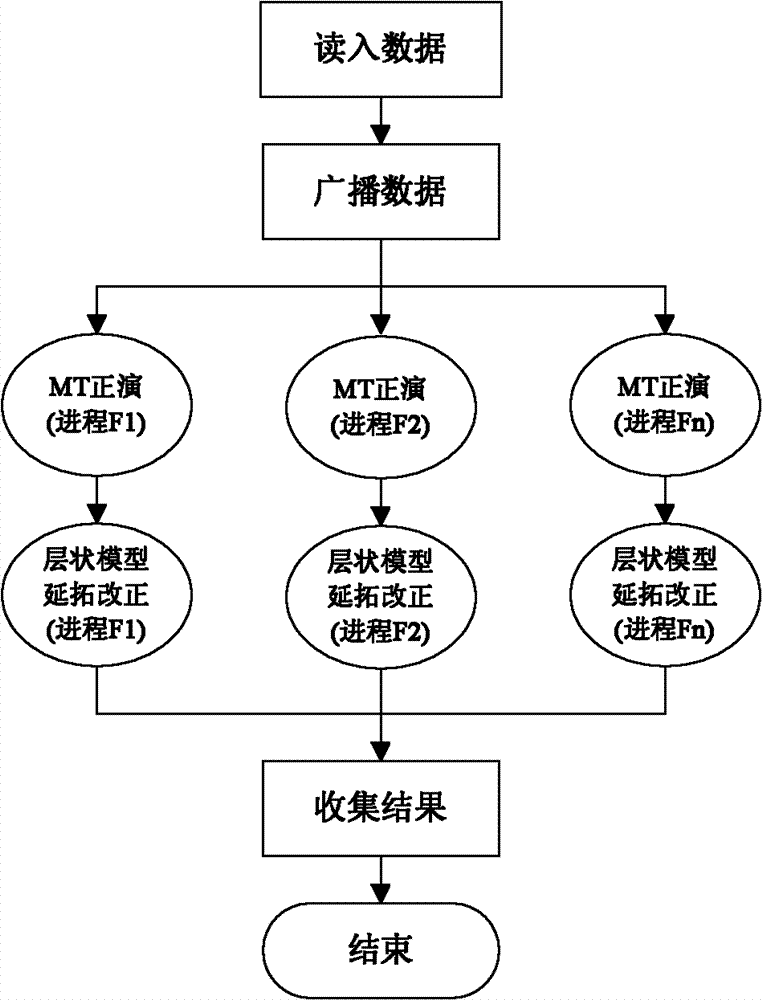
[0037] The specific method is as follows: firstly, geometrically and arithmetically average the upper branch apparent resistivity and phase curves of all measuring points on the CEMP measuring line to obtain an average apparent resistivity and average phase data, and then use the one-dimensional generalized inverse method to invert Or the one-dimensional continuum method inverts the average apparent resistivity and phase curve, and after inversion, the frequency-apparent resistivity relationship of the average curve is changed to the depth-resistivity relationship, so as to obtain the background layered resistivity of the corrected area model, and perform one-dimensional forward modeling on the model to obtain the apparent resistivity ρ lay (f, x) and phase Then, according to the relative elevation data of the survey points, the grid is divided in ...


PUM


Abstract

The invention provides an electromagnetic data terrain correction method, comprising the following steps: actually measuring electromagnetic data, averaging apparent resistivity and phases, changing a frequency-apparent resistivity relationship into a depth-resistivity relationship, obtaining a model which rises and falls with terrains, carrying out a parallel two-dimensional forward modeling according to frequencies, obtaining a two-dimensional forward modeling apparent resistivity and a two-dimensional forward modeling phase of a stratified model with the terrains, gaining the apparent resistivity of the stratified model, and correcting upward and downward continuations according to a one-dimensional impedance recursion formula of the magneto-telluric field and the relative elevations of measuring points. With the adoption of the stratified model and an upward / downward continuation technique relevant with the terrains, the problem that a mirror-image relationship exists between the apparent resistivity and the terrains and between a phase section and the terrains after the application of the traditional method can be suppressed, so that the effect on terrain correction is modified; and meanwhile, the capability and the processing efficiency of the terrain correction can be improved through the adoption of a parallel processing method for the correction of electromagnetic data.

Description

technical field [0001] The invention relates to a geophysical exploration method, and relates to an electromagnetic data terrain correction method in the data processing technology of electromagnetic exploration data. Background technique [0002] Current electromagnetic prospecting methods, including magnetotelluric (MT), audio-frequency magnetotelluric (AMT), and continuous magnetotelluric profiling (CEMP), are mainly concentrated in areas such as complex piedmonts, and electromagnetic data collected under complex terrain conditions Certain distortions will occur, and if these data are not subject to terrain correction, the subsequent processing results will be affected. [0003] The influence of terrain on electromagnetic data has attracted the attention of scholars at home and abroad since the 1980s. Redding, Winnamaker and others have done a lot of work on 2D MT terrain simulation with finite element method. By the end of the 1990s, Chouteau, Wang Xuben, Jin Guangwen, ...

Claims


Application Information

Patent Timeline
Patent Type & Authority Applications(China)
IPC IPC(8): G01V3/38
Inventor 胡祖志何展翔
Owner BC P INC CHINA NAT PETROLEUM CORP
Learn More