Low-altitude unmanned aerial vehicle vision positioning method based on rapid robust feature

A robust feature and visual positioning technology, applied in image data processing, instruments, calculations, etc., can solve the problems of large registration errors and increase the complexity of the method, and achieve the effect of accurate estimation

Inactive Publication Date: 2013-02-20
NORTHWESTERN POLYTECHNICAL UNIV
View PDF3 Cites 20 Cited by
  • Summary
  • Abstract
  • Description
  • Claims
  • Application Information

AI Technical Summary

Problems solved by technology

In general, there are large differences (such as scale, rotation, illumination, etc.) between the ground image (real-time image) acquired by the airborne camera and the satellite digital orthophoto image (reference image), and the traditional method based on template matching is Before image registration, it is necessary to predict the heading deviation of the real-time image relative to the reference image based on the planned track, which increases the complexity of the method and the registration error is large

Method used


Image

  • Low-altitude unmanned aerial vehicle vision positioning method based on rapid robust feature

Examples


Embodiment Construction

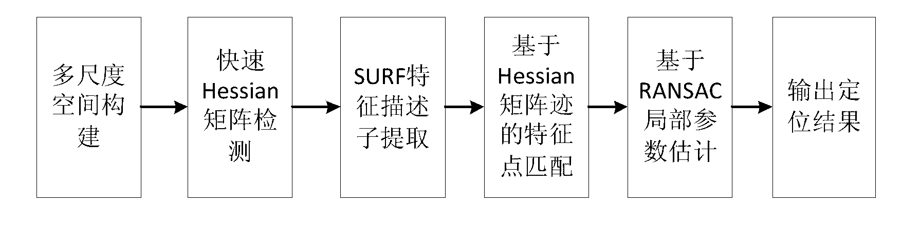
[0020] Now in conjunction with embodiment, accompanying drawing, the present invention will be further described:

[0021] 1. A low-altitude UAV visual positioning method based on fast and robust features, comprising the following steps:

[0022] A. SURF feature point extraction of low-altitude UAV aerial sequence images.

[0023] B. SURF feature point matching of low-altitude UAV aerial sequence images.

[0024] 2. The rapid and robust feature extraction of low-altitude UAV aerial sequence images patented by the present invention, which includes the following aspects:

[0025] A. Multi-scale space construction. When preprocessing the image, the Gaussian kernel is approximated by the box filter, and the calculation speed of the algorithm is greatly improved by using the property that the calculation amount of the box filter is independent of the filter size when calculating the convolution. A multi-scale space is established by computing box filters at different scales.

...


PUM


Abstract

The invention relates to a low-altitude unmanned aerial vehicle vision positioning method based on a rapid robust feature. The low-altitude unmanned aerial vehicle vision positioning method based on the rapid robust feature can be suitable for rotation and size variation of aerial sequential images of a low-altitude unmanned aerial vehicle and noise interference and achieve precise estimation of positions of aircrafts. Firstly, SURF scale space is built, extreme points are positioned by using a rapid Hessian matrix, and 64-dimention SURF feature descriptors of an aviation image are calculated; then feature point matching is completed on the basis of a Hessian matrix track; and finally, outliers are removed by using a random sampling consensus (RANSAC) method so as to achieve precise estimation of position parameters. Transformation parameters between a reference image and a real-time image are obtained through the RANSAC method. After estimation of partial parameters on the basis of RANSAC is completed, and outer points are removed, inner points meeting matching requirements are figured out, and transformation results of estimation parameters of the real-time image based on the RANSAC and positioning results of the center of the real-time image on reference image can be obtained.

Description

technical field [0001] The invention relates to a low-altitude UAV visual positioning method based on fast and robust features, which can adapt to the rotation, scale transformation and noise interference of the low-altitude UAV aviation sequence image, and realize the position parameters of the real-time image acquired by the aircraft on the satellite reference image precise estimate of . Background technique [0002] In visual navigation, low-altitude UAV position parameter estimation is the core of autonomous navigation, and research on high-precision and robust image matching methods is an important means to improve UAV position parameter estimation. [0003] The present invention uses Speeded-up robust features (SURF), that is, a new local invariant feature method, to integrate the gradient information of sub-regions, and can effectively solve the problem of geometric transformation and distortion between the real-time image and the reference image. , Affine transforma...

Claims


Application Information

Patent Timeline
Patent Type & Authority Applications(China)
IPC IPC(8): G06T7/00
Inventor 李耀军潘泉赵春晖杨峰梁彦程咏梅
Owner NORTHWESTERN POLYTECHNICAL UNIV
Why Eureka
Try Eureka