Method for determining best analysis area of relief amplitude

A technology for analyzing areas and fluctuations, applied in special data processing applications, instruments, electrical digital data processing, etc.

Inactive Publication Date: 2013-02-27
THE PLA INFORMATION ENG UNIV
View PDF4 Cites 3 Cited by
  • Summary
  • Abstract
  • Description
  • Claims
  • Application Information

AI Technical Summary

Problems solved by technology

[0021] The purpose of the present invention is to provide a method for determining the optimal analysis area of ​​terrain relief, which is used to solve the problem of inaccurate determination due to the complexity of successive calculations and the randomness of manual judgment in the process of determining the optimal analysis area.

Method used


Image

  • Method for determining best analysis area of relief amplitude
  • Method for determining best analysis area of relief amplitude
  • Method for determining best analysis area of relief amplitude

Examples


specific Embodiment

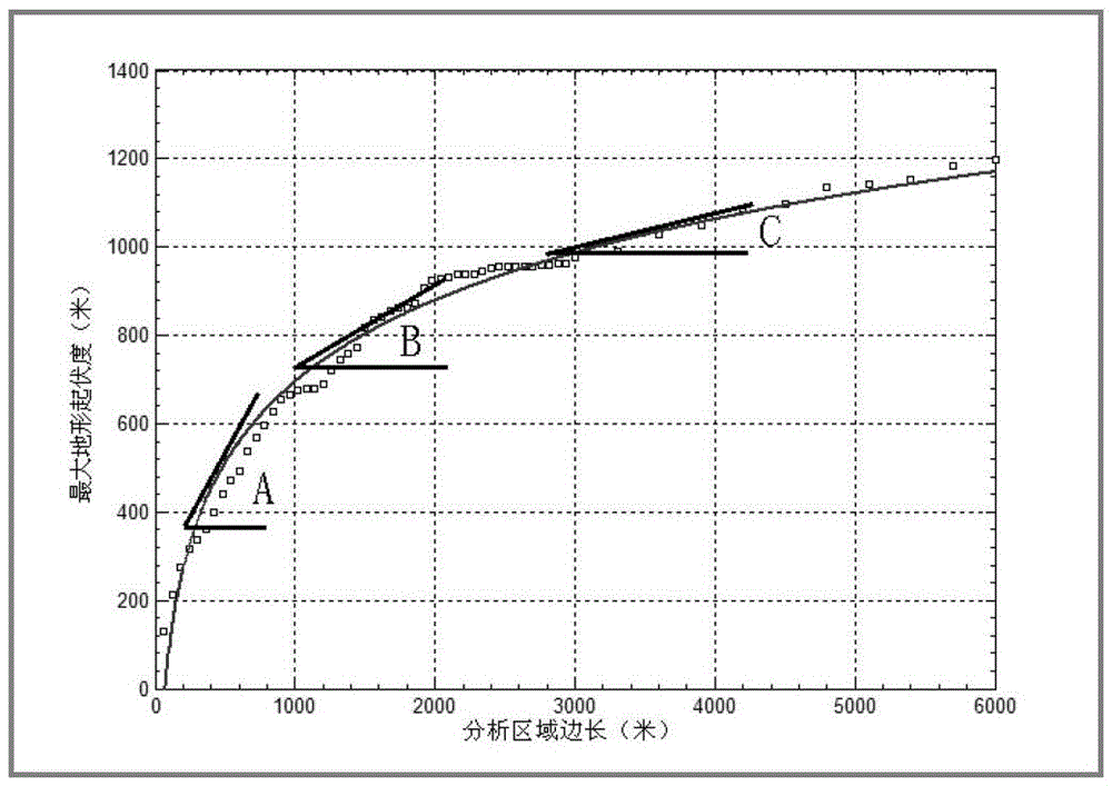
[0093] Taking the national 90m SRTM DEM data as an example, the specific implementation of the present invention will be further described in detail in conjunction with the accompanying drawings.

[0094] Step 1: Data Preparation

[0095] (1.1) Select the national 90m SRTM DEM data as the experimental data, and calculate the micro-topographic factor values ​​such as regional height difference, average elevation, average slope, and average slope variability (Table 6);

[0096] Table 6. Topographic characteristic factor values ​​of the national 90m SRTM DEM data

[0097]

[0098] (1.2) According to the relevant micro-topographic factors of the experimental area, according to formulas (4) and (5), a=1195.9550 and b=6390.4439 are obtained.

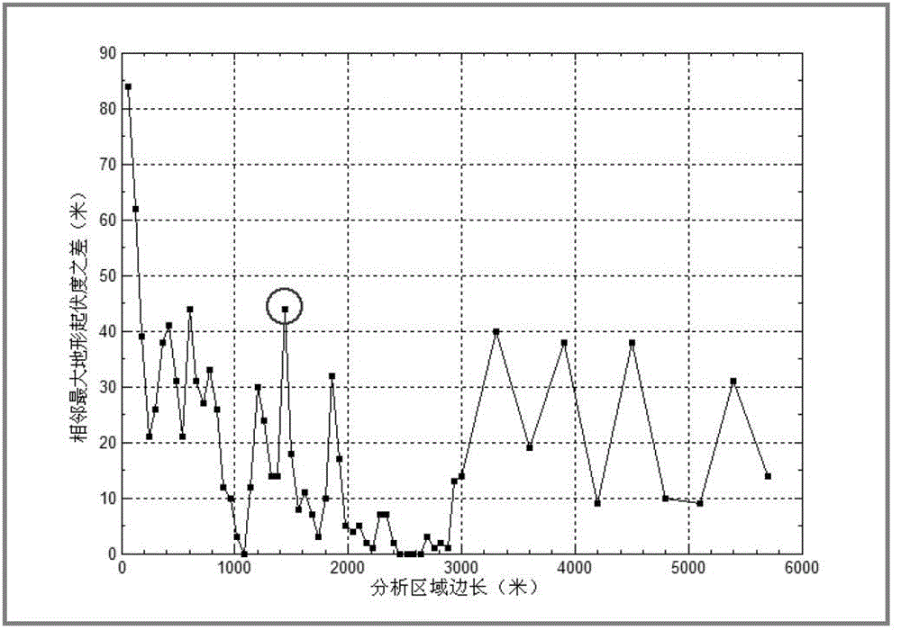
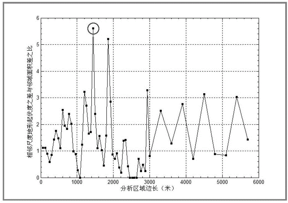
[0099] Step 2: Calculate the slope difference and determine the best analysis area

[0100] (2.1) Sampling x at intervals, and calculating the slope of y=a*lnx-b respectively, that is, k=a / x;

[0101] (2.2) Calculate the difference betwe...


PUM


Abstract

The invention relates to a method for determining best analysis area of relief amplitude, and solves problems of the complexity of successive calculation, the randomness of artificial discrimination and the like in a best analysis area determining process. According to the method, a logarithmic function relationship for analyzing area sides and maximum relief degree values is fully used, a stepwise regression analysis method is used to analyze correlations between logarithmic function factors and experiment area average elevations, height differences, average gradients and average gradient variability, a functional relationship between the maximum relief degree values and the experiment area average elevations, the height differences, the average gradients and the average gradient variability, and the range of the best analysis area of relief amplitude is determined. The method not only can be used in determination of the best analysis area of relief amplitude, but also can be used in determination of best analysis areas of other macro terrain factors.

Description

technical field [0001] The invention relates to a method for determining the best analysis area of ​​terrain relief. Background technique [0002] Terrain relief refers to the difference between the highest point and the lowest point in the analysis area, which reflects the relief characteristics of the terrain in the macroscopic area. It is an important index to quantitatively describe the terrain shape and divide the landform types. The calculation method is shown in formula (1): [0003] R=H max -H min (1) [0004] Among them, R is the terrain relief value in the analysis area, H max 、H min are the highest and lowest elevation values ​​within the analysis area. [0005] The key to terrain relief extraction is to determine the highest and lowest elevation values ​​in the analysis area. However, as the scope of the analysis area changes, the highest and lowest elevation values ​​change accordingly, resulting in changes in...

Claims


Application Information

Patent Timeline
Patent Type & Authority Applications(China)
IPC IPC(8): G06F19/00
Inventor 张锦明游雄万刚付永恒张威巍龚桂荣
Owner THE PLA INFORMATION ENG UNIV
Why Eureka
Try Eureka