

Rapid geographical position search locating system and method
A technology of geographic location and positioning system, applied in measurement devices, electrical digital data processing, special data processing applications, etc., can solve the problems of long character length, inconvenient to memorize, data cannot be disseminated, etc., to achieve short coding length and convenient processing. , easy-to-interpret effects
- Summary
- Abstract
- Description
- Claims
- Application Information
AI Technical Summary
Problems solved by technology
Method used
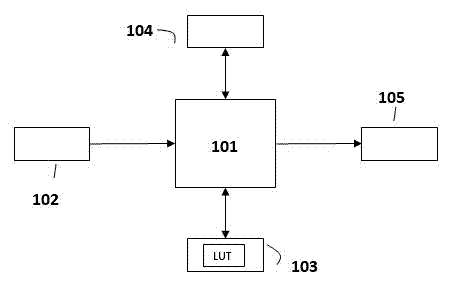
Image


Examples
Embodiment Construction
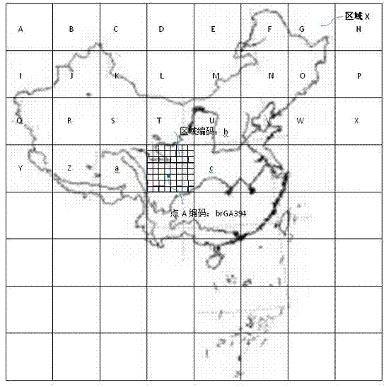
[0037] In an embodiment provided by the present invention, the zoom coding rules adopted may include the following three types, which are:
[0038] First, the 7-bit encoding of the area within China using 8x zoom.
[0039] According to relevant data, the maximum distance from north to south of China's border is about 5500KM, and the maximum distance from east to west is about 5200KM. Therefore, this application uses a square viewfinder frame with a side length of 5500KM, and each zoom factor is 8 times. It can be known by calculation that the accuracy of 7-bit encoding can reach 5500KM / 8^7 which is about 2.62m. Compared with GPS accuracy, this accuracy can fully meet the requirements of location services.
[0040] According to the above calculation, this application needs to use a total of 64 characters of 8*8 for encoding. In order to facilitate computer input and user memory, the application selects 64 commonly used characters to express, that is, 10 Arabic numerals plus ...
PUM
 Abstract
Description
Claims
Application Information