Navigational positioning method based on sky polarization distribution model matching

A distribution model, navigation and positioning technology, applied in the field of navigation and positioning, can solve the problems of poor environmental adaptability and accuracy, insufficient information utilization, and inability to obtain the sun meridian, etc., to achieve good environmental adaptability and accuracy

Inactive Publication Date: 2013-03-13
HEFEI INSTITUTES OF PHYSICAL SCIENCE - CHINESE ACAD OF SCI
View PDF3 Cites 22 Cited by
  • Summary
  • Abstract
  • Description
  • Claims
  • Application Information

AI Technical Summary

Problems solved by technology

In particular, the line of maximum polarization must obtain the complete polarization distribution of the whole sky in order to find the line with the largest polarization in the distribution of polarization, that is, the line of maximum polarization, and the sun meridian is the line passing through the sun and the zenith of the observer, although It can be obtained by observing the local polarization angle distribution directly above the sky. However, in order to ensure sufficient accuracy, it is also necessary to obtain the polarization distribution of the whole sky as much as possible. This is because there are a large number of irregular areas in the polarization distribution of the sky. The sky polarization distribution cannot obtain an accurate solar meridian
[0005] Second, the existing information on the polarization distribution of the sky is not deep enough, only the heading information of the mobile robot can be obtained, and a large number of local features in the polarization distribution of the sky are not fully utilized
[0006] Third, the existing technology for obtaining heading information from the polarization distribution of the sky also needs to be improved
At the same time, in the existing table lookup method, the table used is drawn through years of observation results, and the environmental adaptability and accuracy are relatively poor.

Method used


Image

  • Navigational positioning method based on sky polarization distribution model matching
  • Navigational positioning method based on sky polarization distribution model matching
  • Navigational positioning method based on sky polarization distribution model matching

Examples


Embodiment Construction

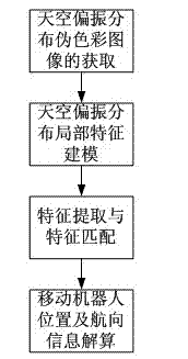
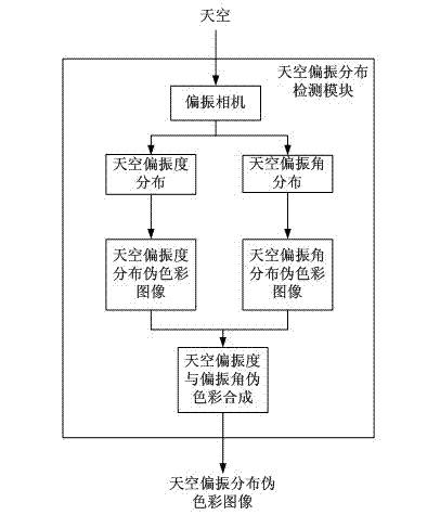
[0033] A navigation and positioning method based on sky polarization distribution model matching, the method includes: (1) taking the positive direction of a mobile robot as a 0-degree reference direction, using a polarization camera to photograph the sky directly above the mobile robot in real time, and obtaining real-time Pseudo-color image of sky polarization distribution; (2) Modeling local features of pseudo-color image of sky polarization distribution; (3) Extracting stable feature points and feature matching of local features of sky polarization distribution pseudo-color image to obtain sky polarization distribution Affine transformation relationship between model graphs; (4) Calculate the position and heading of the mobile robot according to the affine transformation relationship between the sky polarization distribution model graphs. like figure 2 shown.

[0034] like image 3In the first step, take the positive direction of the mobile robot as the reference direct...


PUM


Abstract

The invention relates to a navigational positioning method based on sky polarization distribution model matching. The method comprises the following steps: taking a positive direction of a mobile robot as a 0-degree reference direction, photographing the sky above the mobile robot in real time by employing a polarization camera, acquiring a real-time sky polarization distribution false color image through calculation and synthesis; performing local feature modeling on the sky polarization distribution false color image; performing stable feature point extraction and feature matching on the local features of the sky polarization distribution false color image, and obtaining an affine transformation relationship between the sky polarization distribution model diagrams; and calculating the position and navigational direction of the mobile robot. According to the method, the polarization distribution of the whole sky is not required to be obtained; the local feature information of the sky polarization distribution is utilized, so that the navigational direction of the mobile robot can be acquired from the sky polarization distribution, and the position of the mobile robot can be acquired; and the method is not required to depend on prior knowledge and is high in environmental adaptivity and high in accuracy.

Description

technical field [0001] The invention relates to the field of navigation and positioning, in particular to a navigation and positioning method based on sky polarization distribution model matching. Background technique [0002] Inspired by the ability of ants, bees and other animals to use polarized light for orientation, researchers have carried out extensive and in-depth research on polarization modes in the atmosphere and polarization-based navigation methods. The method of bionic navigation using polarized light has been applied to mobile Various moving objects in the atmosphere such as robots, ships, and aircraft. [0003] At present, the research on sky polarization distribution patterns and navigation methods at home and abroad mainly uses sensors to perceive the distribution information of the sky polarization degree and polarization angle, and then extracts its global features, that is, the solar meridian or the maximum polarization degree line, and then perceives T...

Claims


Application Information

Patent Timeline
Patent Type & Authority Applications(China)
IPC IPC(8): G01C21/02G01C11/08
Inventor 梁华为王道斌梅涛祝辉许铁娟
Owner HEFEI INSTITUTES OF PHYSICAL SCIENCE - CHINESE ACAD OF SCI
Why Eureka
Try Eureka