Determination method for inclined angles of laser reflectors of GEO satellites under multi-observation-station condition

A laser reflection and multi-station technology, applied in the direction of measuring angles, measuring devices, instruments, etc., can solve the problems of not being able to meet the higher needs of users, to increase the effective reflection area, reduce the incident angle, and ensure interchangeability Effect

Active Publication Date: 2015-02-11
BEIJING INST OF SPACECRAFT SYST ENG
View PDF4 Cites 0 Cited by
  • Summary
  • Abstract
  • Description
  • Claims
  • Application Information

AI Technical Summary

Problems solved by technology

Therefore, the existing oblique design method of optical products for a single satellite based on a single specific task can no longer meet the higher needs of users

Method used


Image

  • Determination method for inclined angles of laser reflectors of GEO satellites under multi-observation-station condition
  • Determination method for inclined angles of laser reflectors of GEO satellites under multi-observation-station condition
  • Determination method for inclined angles of laser reflectors of GEO satellites under multi-observation-station condition

Examples


Embodiment Construction

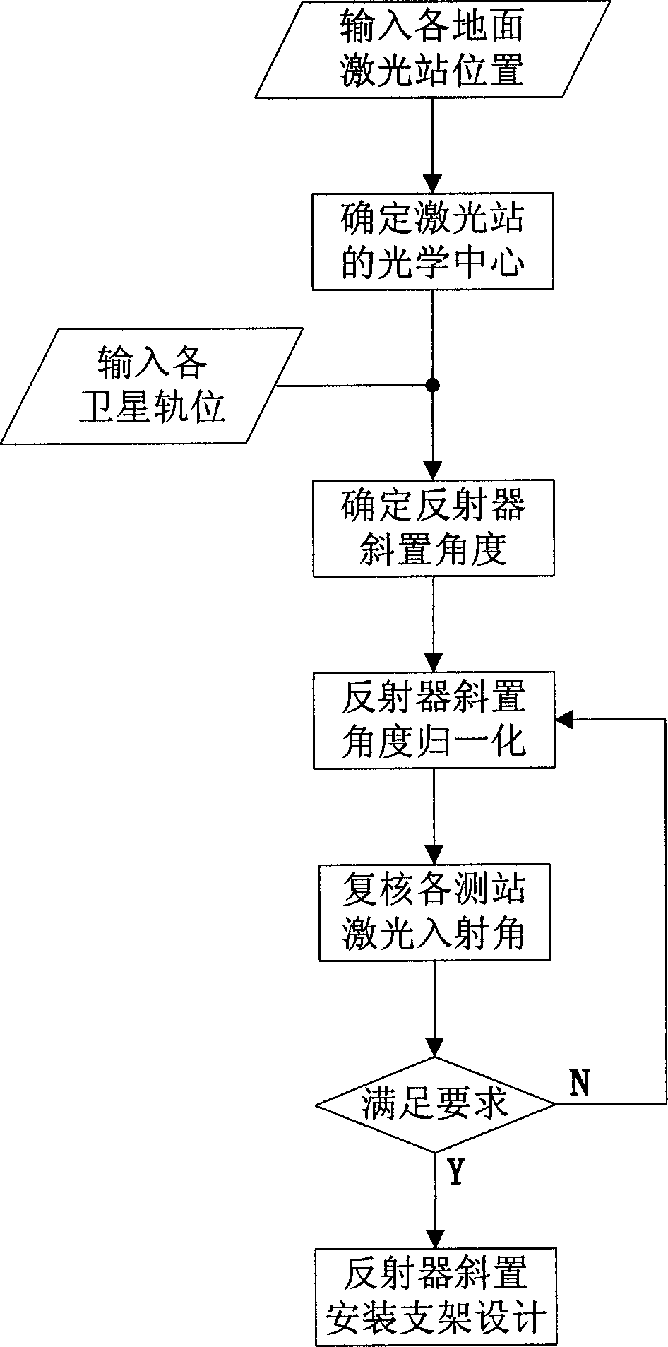
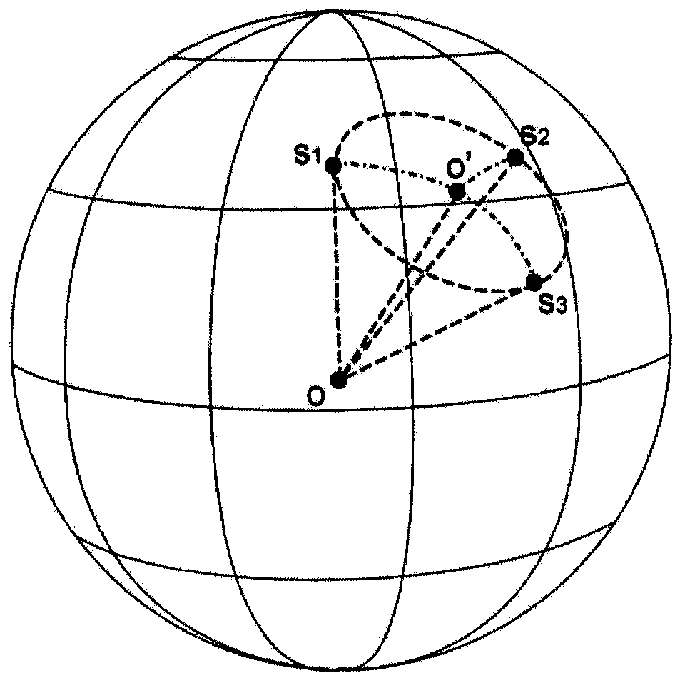
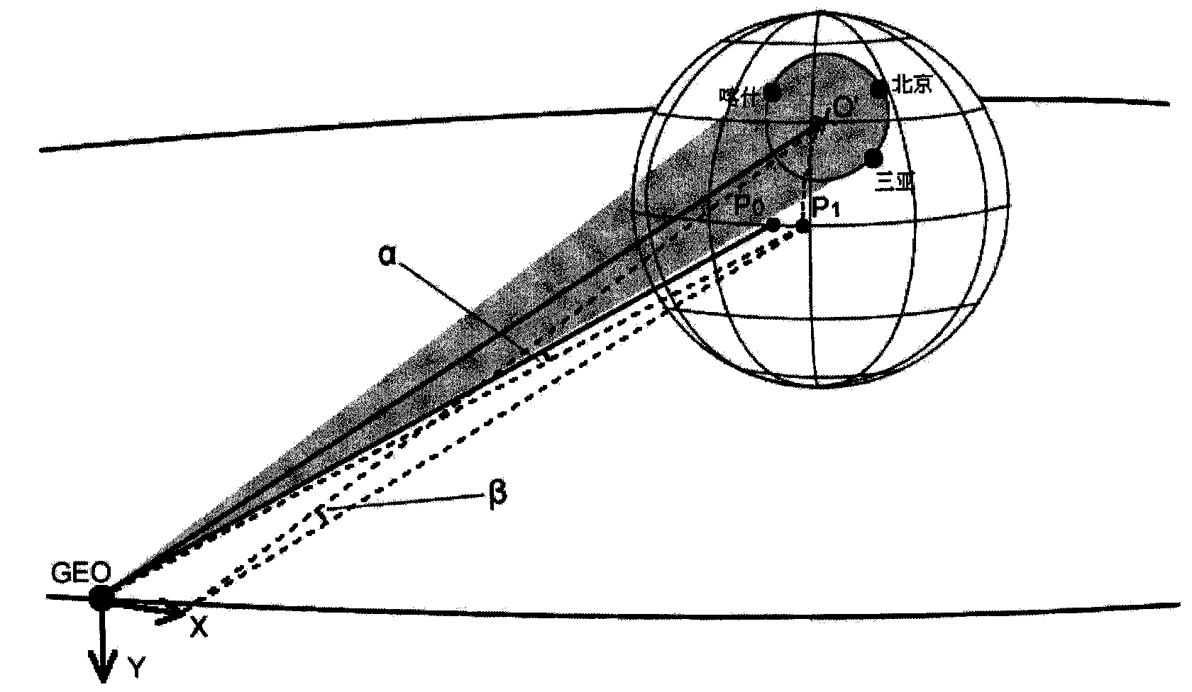
[0019] For multiple GEO navigation satellites serving my country and its surrounding areas, my country has a large territory. According to the current observation requirements, in order to realize multi-station joint observation, it is necessary to have a good geometric distribution of ground observation stations. However, some GEO satellite orbits have poor observation conditions for some laser stations, and may not even meet the requirements of the laser incident angle, so it is impossible to complete the observation of the laser reflector of a certain satellite. For example, the laser reflector of a GEO satellite whose orbital position is westward to measure the geographic longitude eastward may face the above problems, and vice versa. For the same reason, measuring GEO satellites at stations with high geographical latitudes will also face such problems. At the same time, the laser reflector installed on a GEO satellite must also take into account multiple stations with dif...


PUM


Abstract

The invention discloses a determination method for inclined angles of laser reflectors of GEO satellites under a multi-observation-station condition. The determination method comprises the steps that an optical ground center is worked out according to positions of laser observation stations on the ground; distances from the optical center on an earth surface to the laser observation stations on the ground are identical; secondary inclined angles of the laser reflectors in satellite bodies are determined according to positions of satellite orbits and the optical center on the ground; and normal lines of reflecting surfaces of the laser reflectors are allowed to point at the optical center on the ground. As for the multiple satellites, the secondary inclined angles of the laser reflectors of the satellites are worked out respectively; normalization processing of the inclined angles, review of laser incidence angles and design of inclined brackets are performed; technical states of the laser reflectors of the satellites can be unified; and volume production and interchange are facilitated.

Description

technical field [0001] The invention relates to a method for designing oblique installation angles of GEO satellite optical observation products located in different orbital positions (sub-satellite point positions corresponding to different geographical longitudes) and its realization. Background technique [0002] GEO satellites have been widely used in navigation, communication, broadcasting, meteorology and other fields. The determination of its orbital position is mainly determined according to the specific needs of users, and factors such as coverage area and signal frequency need to be considered. In satellite navigation systems, GEO satellites play an extremely important role, especially for systems with regional service capability requirements. In order to provide precise location services, GEO satellites need to perform precise orbit determination, and precise laser ranging is a commonly used method. The laser is emitted by the ground laser station, and the laser ...

Claims


Application Information

Patent Timeline
Patent Type & Authority Patents(China)
IPC IPC(8): G01C1/00G01S7/481
Inventor 胡伟张忠萍王劼陈婉珍谢军刘崇华刘涛潘鑫
Owner BEIJING INST OF SPACECRAFT SYST ENG
Why Eureka
Try Eureka