Navigation system and road matching method and device

A matching method and technology of a matching device, applied in the field of navigation, can solve the problem of not being able to accurately match the correct road section, and achieve the effect of accurate matching

Active Publication Date: 2013-04-10
SHANGHAI PATEO ELECTRONIC EQUIPMENT MANUFACTURING CO LTD
View PDF5 Cites 38 Cited by
  • Summary
  • Abstract
  • Description
  • Claims
  • Application Information

AI Technical Summary

Problems solved by technology

[0015] The problem solved by the present invention is that in the prior art, the parallel road sections with the same heading are in different horizontal planes, and have covering relationship and connection relationship. When the vehicle drives from one horizontal plane road section to another horizontal plane road section, the correct section of

Method used


Image

  • Navigation system and road matching method and device
  • Navigation system and road matching method and device
  • Navigation system and road matching method and device

Examples


Embodiment 1

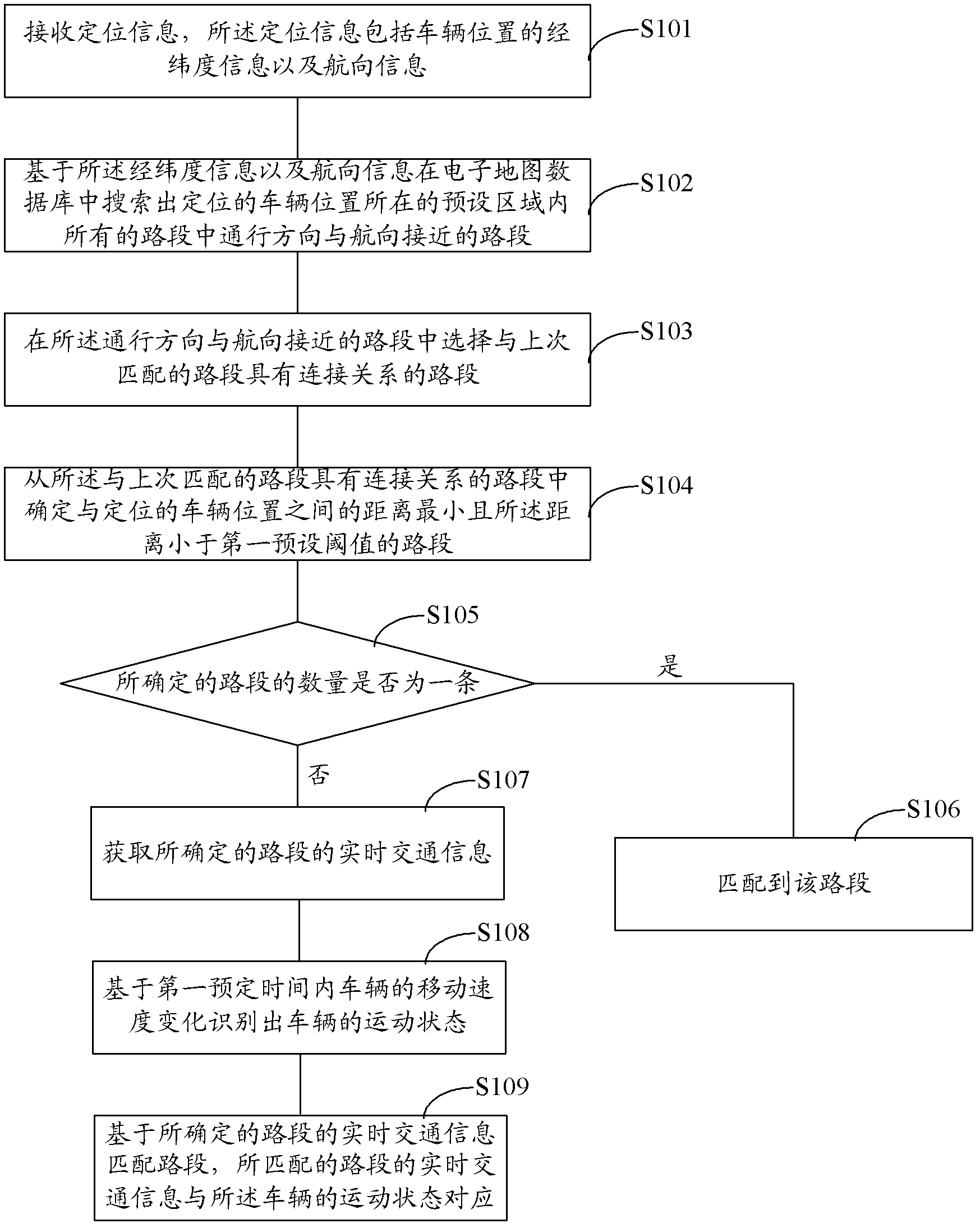
[0054] image 3 It is a schematic flowchart of the road matching method provided in Embodiment 1 of the present invention. like image 3 As shown, the road matching method provided in this embodiment includes:

[0055] Step S101, receiving positioning information, the positioning information including latitude and longitude information and heading information of the vehicle position;

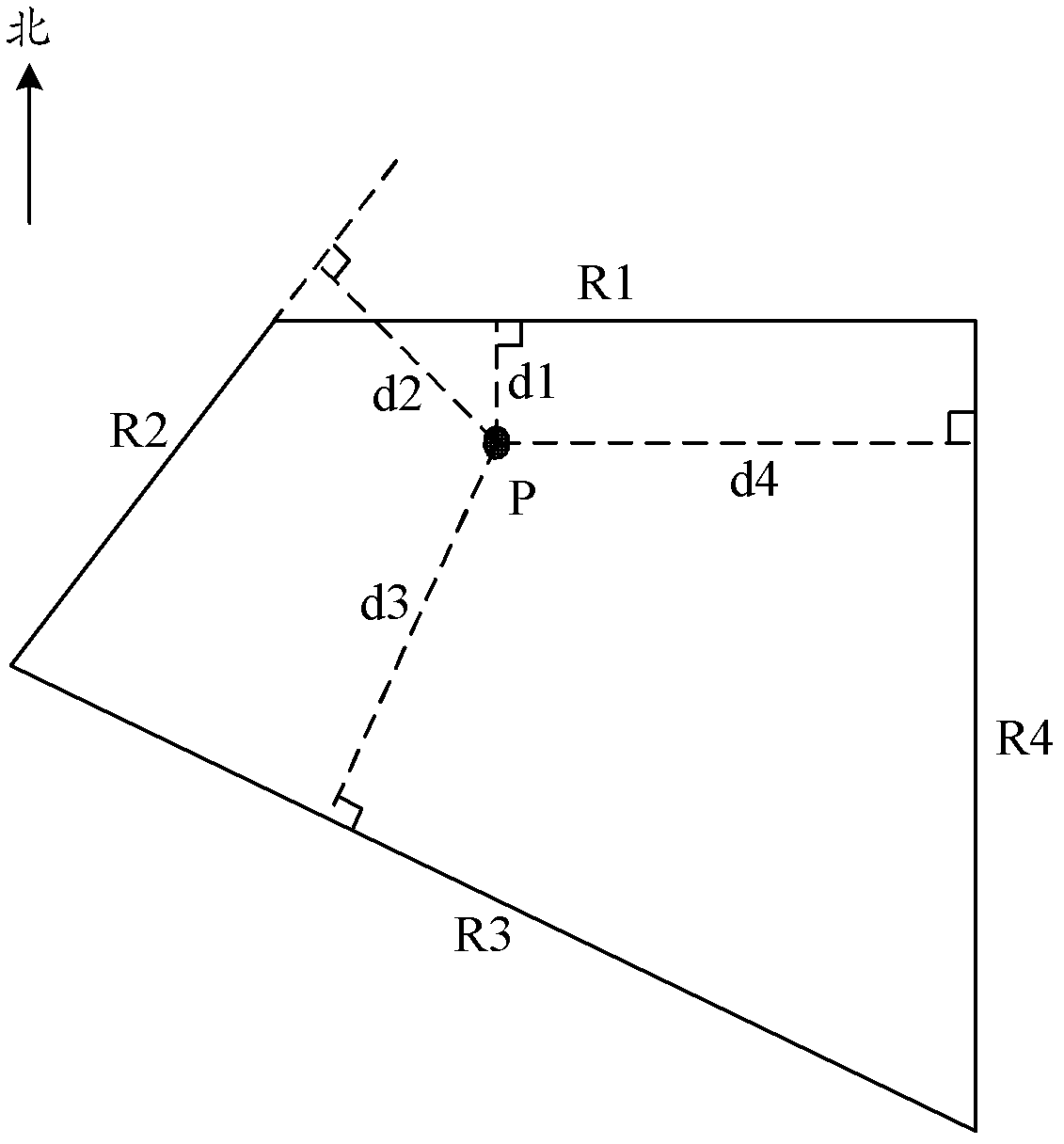
[0056] Step S102, based on the latitude and longitude information and the heading information, search the electronic map database for road sections in which the driving direction is close to the heading among all the road sections in the preset area where the positioned vehicle position is located;

[0057] Step S103, selecting a road segment that has a connection relationship with the last matched road segment among the road segments where the traveling direction and heading are close;

[0058] Step S104, determining the road section with the smallest distance to the positioned vehicle posit...

Embodiment 2

[0103] refer to image 3 The difference between the present embodiment and the first embodiment is that in the first embodiment, after step S108 recognizes the movement state of the vehicle based on the change of the moving speed of the vehicle within the first predetermined time, when it is determined that there is more than one road section among the determined road sections When the real-time traffic information corresponds to the motion state of the vehicle, other methods need to be used to match the determined road section. When corresponding to the motion state of the above-mentioned vehicle, the correct road section can be quickly and accurately matched; on the basis of the first embodiment, this embodiment further solves the problem of real-time traffic information when it is judged that there is more than one road section in the determined road section. How to match the correct road section when the motion state of the vehicle is described above.

[0104] Since the G...

Embodiment 3

[0127] The difference between this embodiment and Embodiment 1 lies in that: the way of identifying the motion state of the vehicle based on the change of the moving speed of the vehicle within the first predetermined time is different. Embodiment 1 By calculating the arithmetic mean value of the sampled values ​​of the moving speed of the vehicle within the first predetermined time period, and then comparing the arithmetic mean value with the second preset threshold and the third preset threshold to identify the vehicle The motion state of the vehicle, the motion state of the vehicle includes stop, stop and start, slow or fast travel; and this embodiment is to carry out linear fitting to the sampling value of the moving speed of the vehicle within the first predetermined time, and then according to The slope of the fitted straight line determines the motion state of the vehicle. The motion state of the vehicle includes uniform motion, acceleration motion, and deceleration moti...


PUM


Abstract

Provided are a navigation system and a road matching method and device. The road matching method comprises receiving positioning information which comprises longitude and latitude of a vehicle position and the driving direction; on the basis the longitude, the latitude and the driving direction, in an electronic map database, searching road sections with the passing directions close to the driving direction in all road sections within a preset area where the positioned vehicle position is located; selecting road sections having connected relations with road sections matched for the last time in the road sections close to the driving direction; determining road sections which have the smallest distance away from the positioned vehicle position and enable the smallest distance to be smaller than a preset threshold in the road sections with the connected relations; if the number of the determined road sections is one, matching to the road section, or else recognizing a motion state of a vehicle on the basis of movement speed changes of the vehicle in first preset time, matching the road sections on the basis of real-time traffic information of the determined road sections, and enabling the real-time traffic information of the matched road sections to correspond to the motion state of the vehicle. According to the technical scheme, the correct road sections can be matched rapidly and accurately.

Description

technical field [0001] The invention relates to the field of navigation, in particular to a navigation system and a road matching method and device. Background technique [0002] Currently, the three important technologies for vehicle navigation and positioning are Global Positioning System (GPS, Global Position System), Dead Reckoning (DR, Dead Reckoning) and Map Matching (MM, Map Matching). [0003] At present, due to the influence of GPS positioning accuracy, and in the case of complex urban roads, high-rise buildings and viaducts often block the signal of the receiver, causing large deviations in GPS positioning information or even losing signals. It is difficult to obtain GPS positioning alone. Satisfactory positioning effect. Dead reckoning can realize the autonomous navigation of the vehicle, but it requires the input of the initial position of the vehicle, and the drift error and calibration error of inertial devices (such as gyroscopes, accelerometers, etc.) will i...

Claims


Application Information

Patent Timeline
Patent Type & Authority Applications(China)
IPC IPC(8): G01S19/39G01C21/30
Inventor 李军
Owner SHANGHAI PATEO ELECTRONIC EQUIPMENT MANUFACTURING CO LTD
Why Eureka
Try Eureka