Graphics stratifying and data processing method based on standard soil layers for use in geotechnical engineering

A technology of geotechnical engineering and data processing, applied in the direction of electrical digital data processing, special data processing applications, instruments, etc., can solve the problems of not reflecting, increasing the workload of geotechnical engineers, and not grasping the core process of stratification of geotechnical engineering , to achieve the effect of improving efficiency

Inactive Publication Date: 2013-05-01
CEEC JIANGSU ELECTRIC POWER DESIGN INST
View PDF1 Cites 7 Cited by
  • Summary
  • Abstract
  • Description
  • Claims
  • Application Information

AI Technical Summary

Problems solved by technology

In terms of implementation methods, no matter whether the existing domestic software is based on database or other data storage methods, at the software application level, the collection of geotechnical engineering layers and the interface expression are all centered on simply listing the contents of the database (see appendix figure 1 ), and this method does not grasp the core process of geotechnical engineering stratification, does not reflect the important role of various tests and test data in geotechnical engineering stratification, and only designs the interface for data collection, causing users to fall into huge data The form interface is at a loss, which also separates the professional analysis process of geotechnical engineers from data collection, increasing the workload of geotechnical engineers in data collation in the field

Method used


Image

  • Graphics stratifying and data processing method based on standard soil layers for use in geotechnical engineering
  • Graphics stratifying and data processing method based on standard soil layers for use in geotechnical engineering
  • Graphics stratifying and data processing method based on standard soil layers for use in geotechnical engineering

Examples


Embodiment Construction

[0017] Below in conjunction with accompanying drawing, the present invention will be further described:

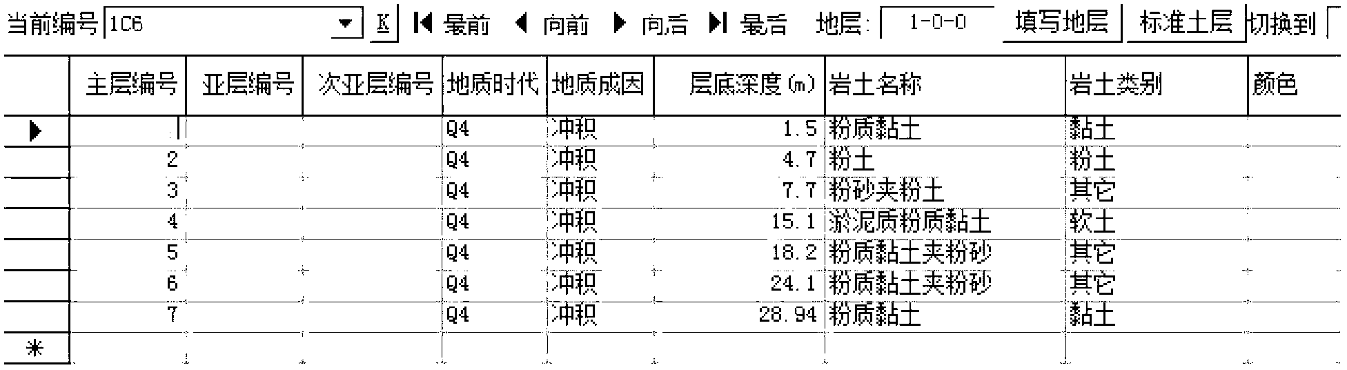
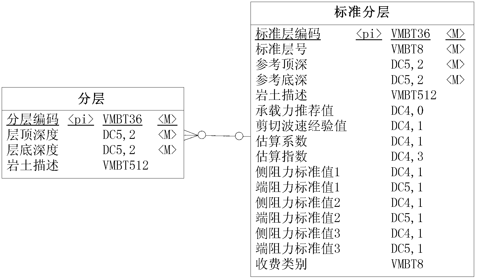
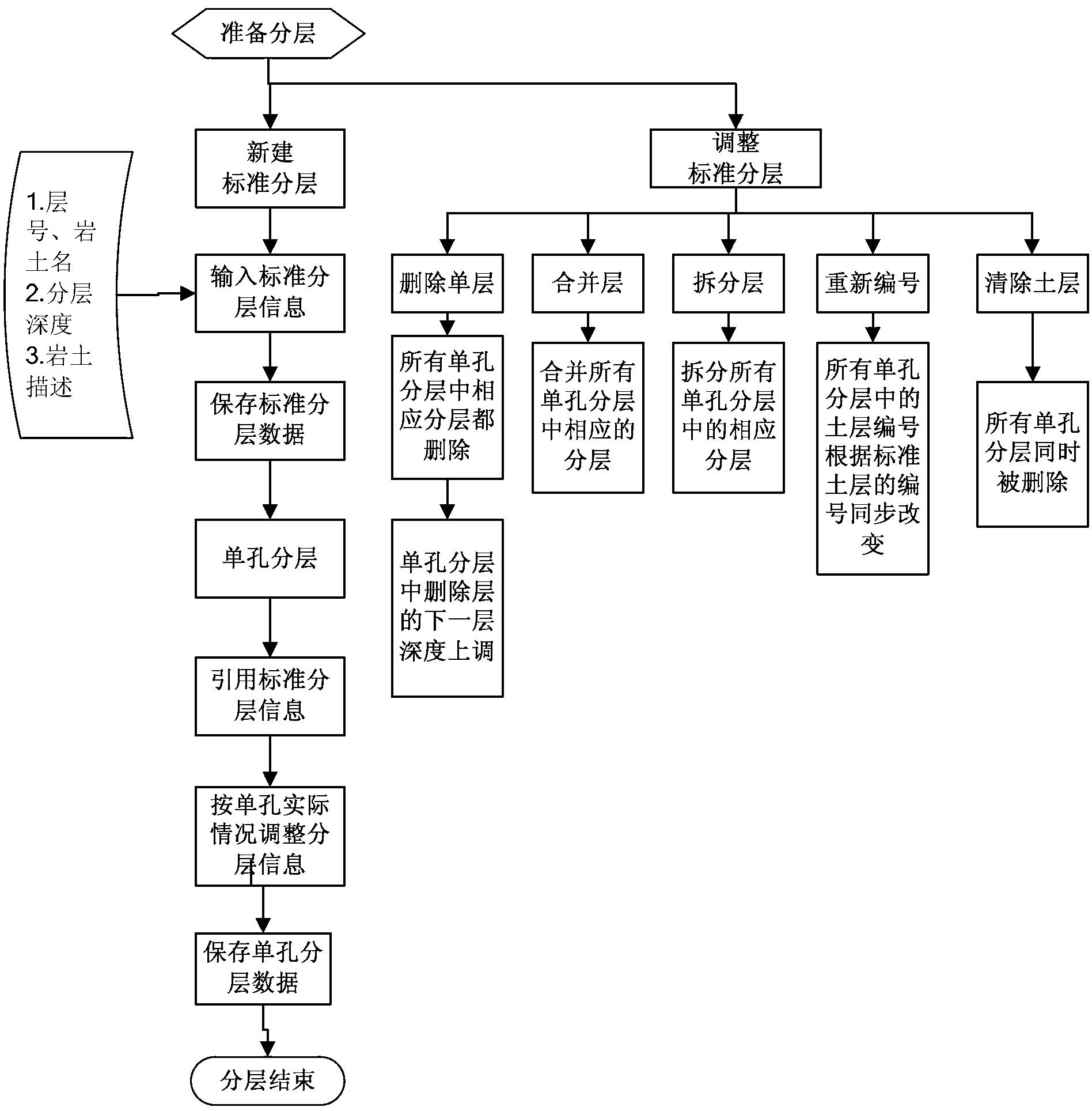
[0018] 1) The geotechnical engineering investigation graphical layering and data processing method based on the standard soil layer of the present invention, the first step is the determination principle and attribute definition of the standard soil layer:

[0019] 11) The standard soil layer is a highly generalized geological model of a certain research site, including all stratum types of the site;

[0020] 12) According to the principle of similar engineering geological characteristics, select representative exploration holes as the standard soil layer extraction model;

[0021] 13) Use the standard model to complete the definition of the characteristics of each layer of the standard soil layer, including determining the name of each soil layer, geological age, cause of formation, state, humidity, and typical soil layer characteristic description information.

[0022] ...


PUM


Abstract

The invention discloses a graphics stratifying and data processing method based on standard soil layers for use in geotechnical engineering. The method comprises the following steps of: (1) under the condition of uniformly analyzing available data, extracting all most representative soil layers in a certain site, and defining the property of each soil layer; (2) establishing a logical relation between the standard soil layers and single hole stratification, i.e. comparing the in-situ test results of exploratory holes by taking each standard soil layer as a template, and deleting horizons which do not occur in each hole on the standard soil layers to complete single hole stratification of the exploratory holes; (3) if selection of the standard soil layers in the template differs during review, modifying the data information of the standard soil layers in the template, and meanwhile, automatically completing corresponding modification of the soil layer data information of each exploratory hole; (4) after obtaining geotechnical engineering stratification data of each hole, performing statistical analysis on the data; and (5) graphically displaying a stratification result and a statistical analysis result. According to the graphics stratifying and data processing method, geologic stratification of geotechnical engineering can be realized rapidly and accurately.

Description

technical field [0001] The invention relates to a graphical layering and data processing method for geotechnical engineering survey, belonging to the technical field of geotechnical engineering survey and computer software. Background technique [0002] At present, the data analysis and processing of geotechnical engineering investigation are all realized by means of computer-aided design software. Among the major geotechnical engineering survey software in China, the processing of engineering geological stratification is the main goal and content of the software. In terms of implementation methods, no matter whether the existing domestic software is based on database or other data storage methods, at the software application level, the collection of geotechnical engineering layers and the interface expression are all centered on simply listing the contents of the database (see appendix figure 1 ), and this method does not grasp the core process of geotechnical engineering ...

Claims


Application Information

Patent Timeline
Patent Type & Authority Applications(China)
IPC IPC(8): G06F17/50
Inventor 任治军任亚群马骁戴洪军葛海明陈念军严忠文
Owner CEEC JIANGSU ELECTRIC POWER DESIGN INST
Why Eureka
Try Eureka