Real-time large-scale terrain visualization implementation method based on kd tree

A technology of large-scale terrain and implementation methods, applied in 3D modeling, image data processing, instruments, etc., can solve the problems of unsatisfactory efficiency and high complexity, and achieve the effect of improving visualization speed, realizing simplicity and reducing use.

Active Publication Date: 2013-05-01
SOUTH CHINA UNIV OF TECH
View PDF2 Cites 23 Cited by
  • Summary
  • Abstract
  • Description
  • Claims
  • Application Information

AI Technical Summary

Problems solved by technology

Although the complex process of updating the Delaunay triangulation in real tim

Method used


Image

  • Real-time large-scale terrain visualization implementation method based on kd tree
  • Real-time large-scale terrain visualization implementation method based on kd tree
  • Real-time large-scale terrain visualization implementation method based on kd tree

Examples


Embodiment

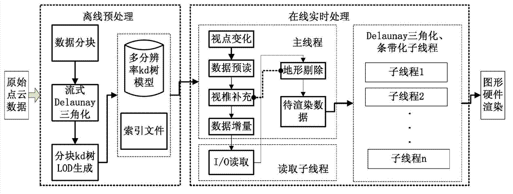
[0057] Such as figure 1 As shown, the kd tree-based real-time large-scale terrain visualization implementation method provided in this embodiment includes the following steps: including the following steps:

[0058] The landform is divided into blocks according to the point cloud space, and the kd tree is used for layering, and the LOD model is established offline. The establishment of the LOD model is responsible for obtaining multi-resolution model data from the terrain point cloud data and switching between the resolutions of the model;

[0059] When online, the LOD model data constructed offline is loaded into the memory by using an external storage algorithm, and the external storage algorithm is responsible for scheduling the LOD model data of the external memory to the memory;

[0060] Using a simplified terrain removal technology for the LOD model data in the memory, the terrain data removal technology is responsible for removing invisible LOD model data, reducing the ...


PUM


Abstract

The invention discloses a real-time large-scale terrain visualization implementation method based on a kd tree. The real-time large-scale terrain visualization implementation method comprises the following steps: partitioning terrain according to a point cloud space; off line establishing an LOD (level of detail) model by utilizing kd tree layering, wherein the established LOD model is responsible for obtaining multi-resolution model data by the terrain point cloud data, and switching each resolution ratio of the model; loading the off line constructed LOD model data into a memory by utilizing an external storage algorithm when on line, wherein the external storage algorithm is responsible for scheduling the externally stored LOD model data to the memory; utilizing a simplified terrain eliminating technology to the LOD model data in the memory, wherein the simplified terrain establishing technology is responsible for eliminating invisible LOD model data, so as to reduce the amount of the data transmitted to graphical hardware; and further reducing the data mount and calculation amount of the eliminated data transmitted to the graphical hardware by utilizing a three-dimensional engine optimization technique. The real-time large-scale terrain visualization implementation method based on the kd tree is simple to realize and high in display efficiency and has excellent visualization effect based on a triangular irregular network visualization algorithm, so that the visualization speed is improved.

Description

technical field [0001] The invention relates to the technical field of three-dimensional visualization of large-scale terrain point clouds, in particular to a real-time large-scale terrain visualization method based on a kd tree. Background technique [0002] The 3D visualization of terrain point cloud is based on the principle of computer graphics, which converts 3D terrain data (including discrete point clouds and point sequences of triangular pieces formed between points) through view transformation, model transformation, projection transformation and viewport transformation, etc. A series of operations are finally displayed on the two-dimensional screen. When the amount of terrain data is large, the number of operations to be transformed will also increase dramatically. This requires the use of some algorithms that improve the efficiency of 3D visualization of terrain data in order to meet its real-time display requirements. [0003] The industry's research on efficient...

Claims


Application Information

Patent Timeline
IPC IPC(8): G06T17/00
Inventor 裴海龙姚定忠
Owner SOUTH CHINA UNIV OF TECH
Why Eureka
Try Eureka