Supercharge Your Innovation With Domain-Expert AI Agents!

Hand-held terminal of global navigation satellites system and centering and levelling method thereof

A technology of global navigation satellites and handheld terminals, applied in the field of GNSS handheld terminals, can solve problems such as increasing workload

Inactive Publication Date: 2013-05-08
SHANGHAI BEIGA NAVIGATION TECH CO LTD
View PDF0 Cites 7 Cited by
  • Summary
  • Abstract
  • Description
  • Claims
  • Application Information

AI Technical Summary

Problems solved by technology

[0007] In the actual operation process, the tip of the centering rod is pressed against the measured point, and the operator continuously adjusts the angle of the centering rod according to the position of the bubble to keep the centering rod perpendicular to the horizontal plane. This adjustment needs to be continued during the terminal positioning process. , thus significantly increasing the workload

Method used


Image

  • Hand-held terminal of global navigation satellites system and centering and levelling method thereof
  • Hand-held terminal of global navigation satellites system and centering and levelling method thereof
  • Hand-held terminal of global navigation satellites system and centering and levelling method thereof

Examples


Embodiment Construction

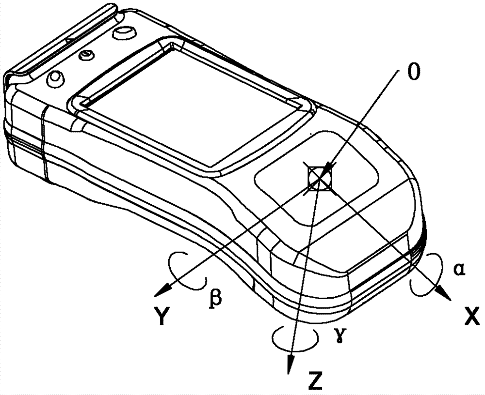
[0024] The embodiments to be described of the present invention relate to handheld terminals of the Global Navigation Satellite System (GNSS). Here, the GNSS system may include global systems, such as the GPS system of the United States, the GLONASS system of Russia, the Galileo system of Europe, the Beidou system of China, etc., and may also include regional systems, such as the QZSS quasi-zenith satellite system of Japan, India’s IRNSS regional satellite navigation system, etc. The handheld terminal can be a device dedicated to satellite navigation, or a multifunctional device integrated with satellite navigation functions. In addition, the handheld terminal may be compatible with multiple GNSS systems.

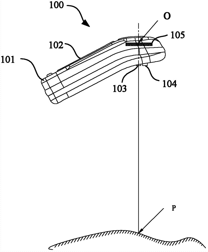
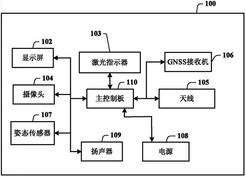
[0025] figure 1 A side view showing a handheld terminal according to an embodiment of the present invention. The handheld terminal 100 includes a housing 101, a display screen 102 is arranged on the front of the housing, and a laser pointer 103 and a camera 104 are arran...


PUM


Abstract

The invention provides a hand-held terminal of global navigation satellites system and a centering and levelling method of the hand-held terminal without using a centering rod. The hand-held terminal comprises a shell body, a display screen which is arranged on the front of the shell body, and the shell body which is provided with a satellites antenna. The back of the shell body is provided with a laser designator and a camera, wherein the laser designator is used for issuing light beams to ground to form light-spots, and the camera is used for shooting images of measured points and the light-spots. In addition, an attitude sensor is arranged inside the shell body, and the attitude sensor is used for sensing a pitch angle and a roll angle of the satellites antenna. The display screen, the laser designator, the camera and the attitude sensor are connected to a main control panel which is arranged inside the shell body.

Description

technical field [0001] The present invention relates to a global navigation satellite system (Global navigation Satellites System, GNSS), in particular to a GNSS handheld terminal. Background technique [0002] GNSS is the general term for satellite navigation systems, which can be divided into global systems, regional systems, and augmentation systems. Global systems include the GPS system of the United States, the GLONASS system of Russia, the Galileo system of Europe, the Beidou system of China, the DORIS satellite-based radio Doppler orbit determination system of France, the PRARE satellite station distance and distance change rate measurement system of Germany, etc. . Regional systems include: Japan's QZSS quasi-zenith satellite system, India's IRNSS regional satellite navigation system, etc. Augmentation systems include: STARFIRE global space-based differential system, WAAS wide-area augmentation system, EGNOS European wide-area augmentation system, Japan's MSAS augm...

Claims


Application Information

Patent Timeline
Patent Type & Authority Applications(China)
IPC IPC(8): G01S19/13G01C1/00
Inventor 胡华俞江虹郁宏伟韩友东李庆武姚刚刘峻宁毕勤
Owner SHANGHAI BEIGA NAVIGATION TECH CO LTD
Features
  • R&D
  • Intellectual Property
  • Life Sciences
  • Materials
  • Tech Scout
  • Unparalleled Data Quality
  • Higher Quality Content
  • 60% Fewer Hallucinations
Learn More