Digital geological compass and method for measuring geological occurrence

A compass, geological body technology, applied to compasses, measuring devices, instruments, etc., can solve the problems of relatively long time, time-consuming observation pointer balance, low operation efficiency, etc., to achieve convenient operation, high precision, and reduced operation time. Effect

Active Publication Date: 2013-06-19
XIAN UNIV OF SCI & TECH
View PDF5 Cites 20 Cited by
  • Summary
  • Abstract
  • Description
  • Claims
  • Application Information

AI Technical Summary

Problems solved by technology

When reading the data after the relative level or reading the center value of the pointer drift or manually controlling the pointer to stop swinging, there will also be an error of at least 1-3 degrees at this time, and the accumulation of the aforementioned errors will produce a larger error
However, when the mechanical parts are aging and the operating environment is harsh, the error of the traditional compass will be greater
When measuring the inclination, you need to obtain the horizontal direction first, which will also cause a large

Method used


Image

  • Digital geological compass and method for measuring geological occurrence
  • Digital geological compass and method for measuring geological occurrence

Examples


Embodiment Construction

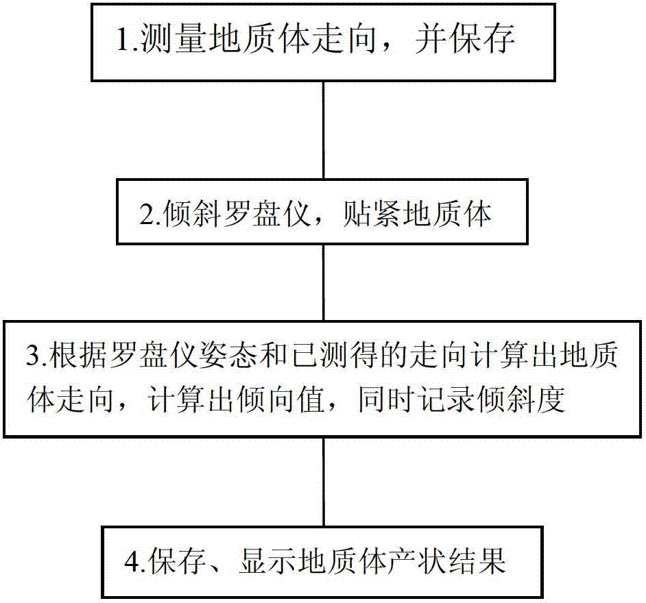
[0043] The present invention will be described in further detail below in conjunction with the accompanying drawings, which are explanations rather than limitations of the present invention.

[0044] Below in conjunction with accompanying drawing, digital geological compass for mining of the present invention is described in detail:

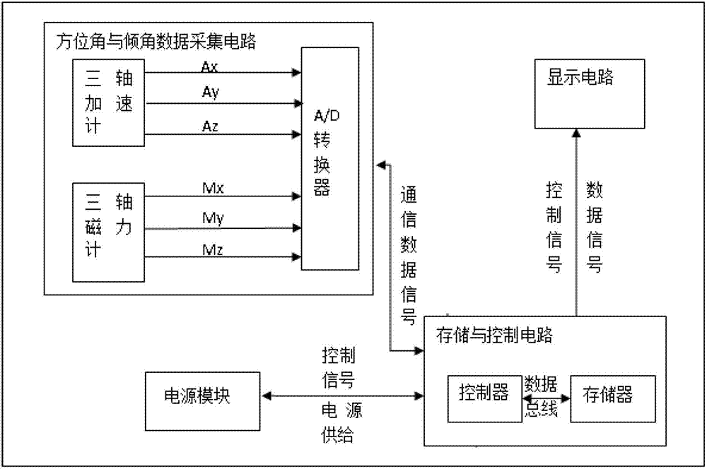
[0045] see figure 1 , a digital geological compass with laser pointing, characterized in that the housing is provided with an azimuth and inclination data acquisition module, a laser module, a power circuit and a display module that are respectively connected to the storage and control modules;

[0046] The azimuth and inclination data acquisition and conditioning module includes a magnetic sensor, an acceleration sensor and an A / D converter, and the A / D converter adjusts the raw data collected by the magnetic sensor and the acceleration sensor and sends it to storage and control circuit;

[0047]The storage and control module reads the azimuth...


PUM


Abstract

The invention provides a digital geological compass and a method for measuring geological occurrence, an azimuth angle and inclination angle data acquisition module, a laser module, a power supply circuit and a display module respectively connected to a storage and control module are provided in a casing; the azimuth angle and inclination angle data acquisition module comprises a magnetic sensor, an acceleration sensor and an A/D converter; the storage and control module reads the azimuth angle and inclination angle data measured by the azimuth angle and inclination angle data acquisition module, a pitching angle and a roll angle are obtained, the azimuth angle, the pitching angle and the roll angle data are sent to the display module for displaying and storing when necessary. The digital geological compass and the method for measuring geological occurrence have the advantages of high precision, convenient operation and high efficiency, and have angle compensation function by using a three-dimensional (shaft) technology when the azimuth angle is read, the real-time reading under compass horizontal are not necessary, so that the operation time can be greatly reduced.

Description

technical field [0001] The invention belongs to the technical field of geological compass and relates to a digital geological compass and a method for measuring the occurrence of geological bodies. Background technique [0002] At present, geological compasses are designed with mechanical pointers, which are often used to measure the azimuth (strike, dip) and dip of various geological structures. This compass has the following disadvantages: [0003] (1) Large errors in measurement accuracy: For example, when measuring azimuth, it is necessary to maintain a relative level first, which requires observing the centered balance of the mercury bubble used to measure the level. There will be observation errors due to the vibration generated by the hand-held compass. When reading the data after the relative level or reading the center value of the pointer drift or manually controlling the pointer to stop swinging, there will also be an error of at least 1-3 degrees at this time, a...

Claims


Application Information

Patent Timeline
IPC IPC(8): G01C17/02
Inventor 马庆勋肖永强马培铨马培洲
Owner XIAN UNIV OF SCI & TECH
Why Eureka
Try Eureka