Large-batch automatic hyperspectral remote sensing mineral mapping method

A hyperspectral remote sensing and batch technology, applied in the field of hyperspectral remote sensing mineral mapping, can solve problems such as difficulty in adapting to engineering applications, many manual participation, and many calculation steps

Inactive Publication Date: 2013-06-26
CHINA AERO GEOPHYSICAL SURVEY & REMOTE SENSING CENT FOR LAND & RESOURCES
View PDF3 Cites 17 Cited by
  • Summary
  • Abstract
  • Description
  • Claims
  • Application Information

AI Technical Summary

Problems solved by technology

[0004] The purpose of the present invention is to propose a batch and automatic hyperspectral remote sensing mineral mapping method, which ...

Method used


Image

  • Large-batch automatic hyperspectral remote sensing mineral mapping method
  • Large-batch automatic hyperspectral remote sensing mineral mapping method
  • Large-batch automatic hyperspectral remote sensing mineral mapping method

Examples


Embodiment Construction

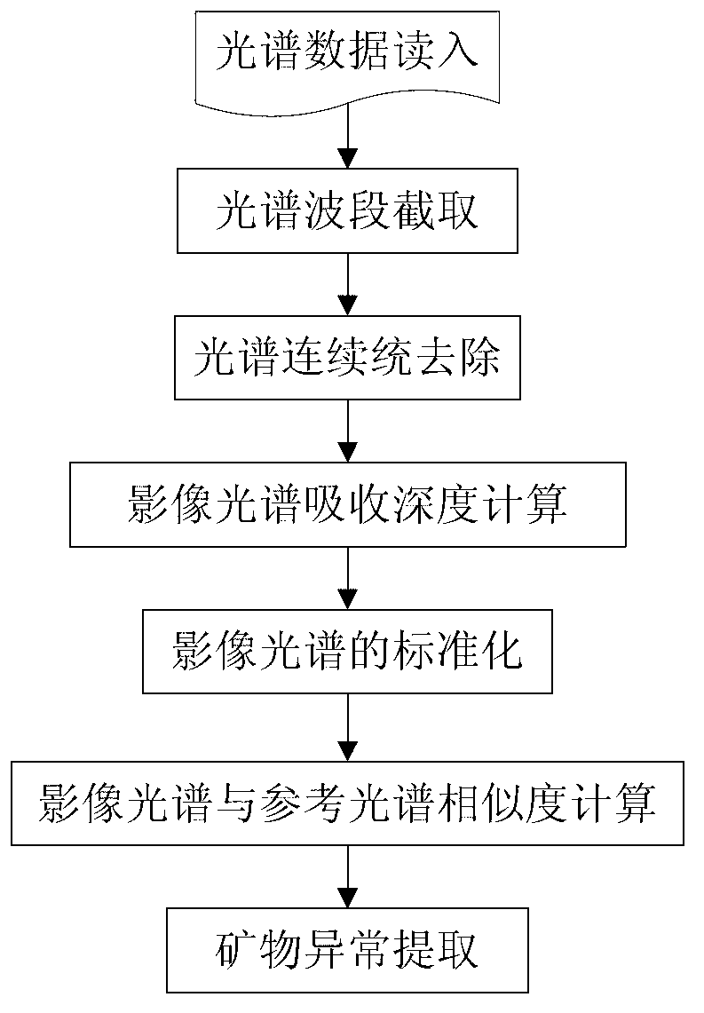
[0037] See attached figure 1 , in order to better illustrate the method and steps of the present invention, using AVIRIS airborne hyperspectral data in a certain area as an example, a mineral mapping test was carried out.

[0038] (1) The equipment used in the test is a graphics workstation, the specification model is Dell Precision 4700, the operating system is WindowsXP (64-bit), the CPU is 2.66GHz, the content is 32GB, and the hard disk is 1T.

[0039] (2) The specific steps are as follows:

[0040] Step 1, read in the AVIRIS hyperspectral remote sensing data and reference spectral data in the Cuprite area of ​​the United States. The AVIRIS hyperspectral remote sensing data has a length×width of 400×350 pixels, a spectral range of 1990.8—2479nm, and a number of 50 bands. The reference spectral data is taken from the USGS mineral spectral library, including high-alumina muscovite (absorption position at 2200.8nm), medium-alumina muscovite (absorption position at 2210.8nm),...


PUM


Abstract

A large-batch automatic hyperspectral remote sensing mineral mapping method comprises seven major steps of: step 1, reading in spectroscopic data; step 2, intercepting a spectral band; step 3, performing continuum removal of the spectrum; step 4, calculating the absorption depth of the image spectrum; step 5, standardizing the image spectrum; step 6, calculating the similarity of the image spectrum to a reference spectrum; and step 7, extracting mineral abnormity according to the calculation results of the step 5 and the step 6. The method does not need to extract the reference spectrum from the hyperspectral remote sensing and perform artificial interpretation; the same reference spectrum is used for the processing of all data so that large-batch and automatic processing of data can be realized conveniently; and the spectrum similarity and the characteristic parameters are comprehensively utilized for mineral abnormity extraction, and the reliability and the accuracy of mineral recognition are improved. The large-batch automatic hyperspectral remote sensing mineral mapping method has practicable value and wide application prospect in the field of hyperspectral remote sensing geological exploration engineering application.

Description

technical field [0001] The invention relates to a batch and automatic hyperspectral remote sensing mineral mapping method, which belongs to the technical field of hyperspectral remote sensing mineral identification, and is suitable for batch and automatic processing of a large amount of data in hyperspectral remote sensing geological exploration, and extracting mineral types , to semiquantitatively estimate mineral content. Background technique [0002] Hyperspectral remote sensing has the characteristics of map-spectrum integration and is widely used in geological exploration. It can identify mineral information based on the fine spectral characteristics of minerals. There are three commonly used identification methods: methods based on spectral expert knowledge, methods based on spectral similarity, and methods based on spectral decomposition. [0003] The basic idea of ​​the method based on spectral expert knowledge is to integrate various spectral expert knowledge (spec...

Claims


Application Information

Patent Timeline
IPC IPC(8): G01N21/31G01V8/10
Inventor 闫柏琨杨苏明王润生
Owner CHINA AERO GEOPHYSICAL SURVEY & REMOTE SENSING CENT FOR LAND & RESOURCES
Why Eureka
Try Eureka