
Method for quickly and accurately positioning administrative region of current coordinates

A technology of current coordinates and administrative areas, applied in special data processing applications, instruments, electrical digital data processing, etc., can solve problems such as unreliability and inefficiency, and achieve the effects of increasing confidentiality, improving response time, and high concurrency

Inactive Publication Date: 2013-07-03
TERRA DIGITAL CREATING SCI & TECH BEIJING CO LTD
View PDF4 Cites 2 Cited by
  • Summary
  • Abstract
  • Description
  • Claims
  • Application Information

AI Technical Summary

Problems solved by technology

Although users can identify according to the markings on the map, this identification is artificial, so it is very inefficient and unreliable

Method used


Image

  • Method for quickly and accurately positioning administrative region of current coordinates
  • Method for quickly and accurately positioning administrative region of current coordinates
  • Method for quickly and accurately positioning administrative region of current coordinates

Examples


Embodiment Construction

[0017] In order to make the above objects, features and advantages of the present invention more comprehensible, the specific implementation manners of the present invention will be described in more detail below in conjunction with the accompanying drawings.

[0018] In the following description, many specific details are set forth in order to fully understand the present invention, but the present invention can also be implemented in other ways different from this description, so the present invention is not limited by the specific embodiments disclosed below.

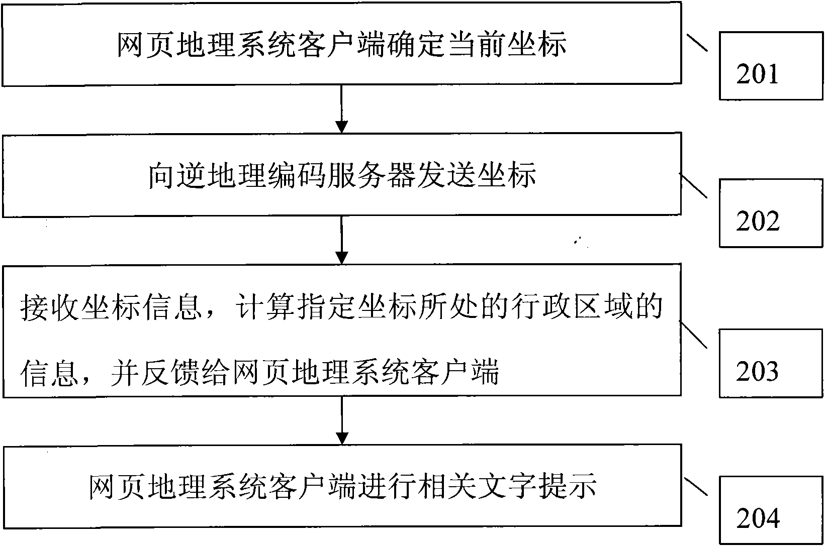
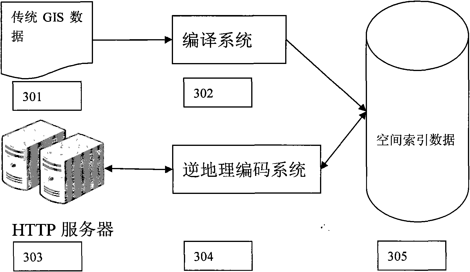
[0019] attached figure 1 It is a composition structure diagram of the reverse geocoding system used by the webpage geographic system of the embodiment of the present invention, including a webpage geographic system client 101 and a reverse geocoding server 102, wherein:

[0020] The webpage geographic system client 101 is responsible for determining the coordinates that the webpage geographic system user needs to que...


PUM


Abstract

The invention discloses a method for quickly and accurately positioning an administrative region of current coordinates, i.e., a reverse geocoding system. According to the method, the problem for quickly positioning the administrative region of the current coordinates is solved. The method mainly comprises two systems, of which one is a data compiling system for compiling the conventional GIS (Geographical Information System) data with space data into a binary user-defined file format, and the other system is a reverse geocoding service system for providing high-efficiency reverse geocoding service for a web geosystem through an HTTP (Hypertext Transfer Protocol) server according to a file generated by the first system as a database.

Description

technical field [0001] The invention relates to an inverse geocoding system, more specifically, the invention is an administrative area searched for a given coordinate location through coordinates. Background technique [0002] With the continuous development of domestic web geography systems, more and more industry system platforms have introduced web geography systems. Therefore, the web geographic system must not only provide high-quality geographic information services, but also introduce other auxiliary systems for the convenience of users browsing the web, so as to provide better humanized services for web geographic system users. [0003] When a webpage user browses the webpage geographic system, he often does not know the geographical area where the webpage is browsed, and thus does not know how to perform the next regional operation. Although users can identify according to the markings on the map, this identification is artificial, so it is very inefficient and un...

Claims


Application Information

Patent Timeline
IPC IPC(8): G06F17/30
Inventor 刘俊伟李同高柴崎
Owner TERRA DIGITAL CREATING SCI & TECH BEIJING CO LTD
Learn More