Method and device for compression and decompression of vector map data
A technology of vector map data and point data, applied in the field of information processing, can solve the problem of limited compression efficiency of vector map data, and achieve the effect of high compression efficiency and improved utilization.
- Summary
- Abstract
- Description
- Claims
- Application Information
AI Technical Summary
Problems solved by technology
Method used
Image

Examples
Embodiment 1
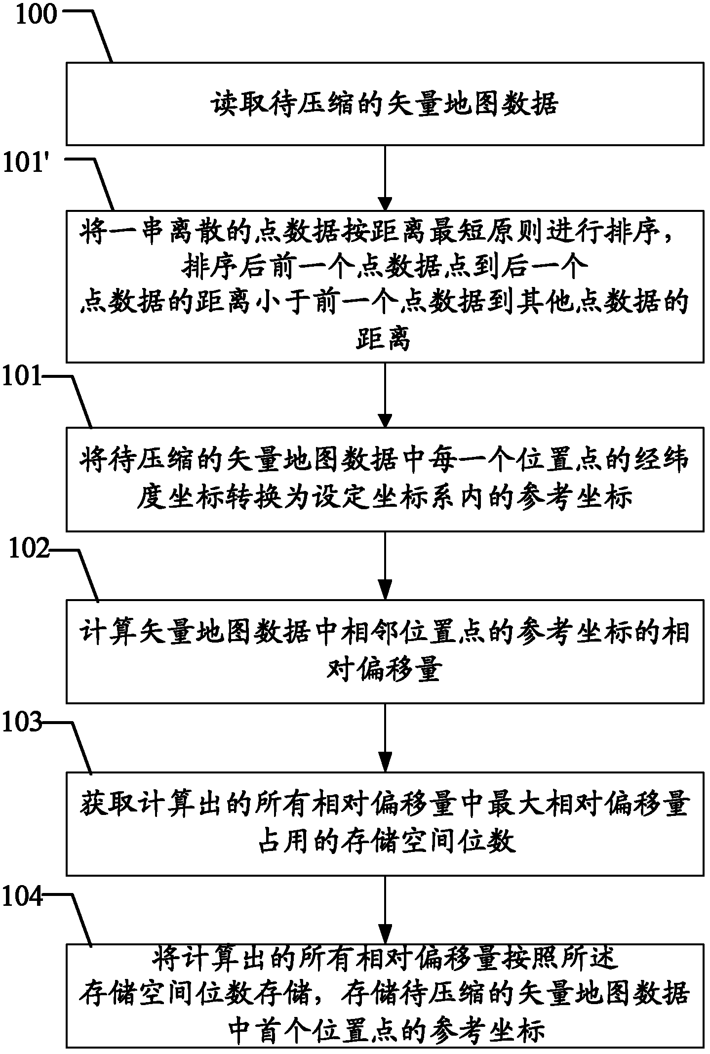
[0039] Embodiments of the present invention provide a method for vector map data compression, such as figure 1 As shown, the method includes:
[0040] Step 100: read the vector map data to be compressed;
[0041] Step 101: converting the latitude and longitude coordinates of each location point in the vector map data to be compressed into reference coordinates in the set coordinate system;
[0042] It should be noted that the vector map data includes: point data, line data and area data. For example: various roads, provincial boundaries, national boundaries, etc. can be considered as line data; various green spaces, water systems, continental surfaces, etc. can be considered as surface data; POI (Point of Interest) data can be considered as point data. Moreover, both the line data and the surface data are composed of a series of spatially continuous position points, and the spatially continuous position points refer to adjacent position points with the shortest distance in s...
Embodiment 2
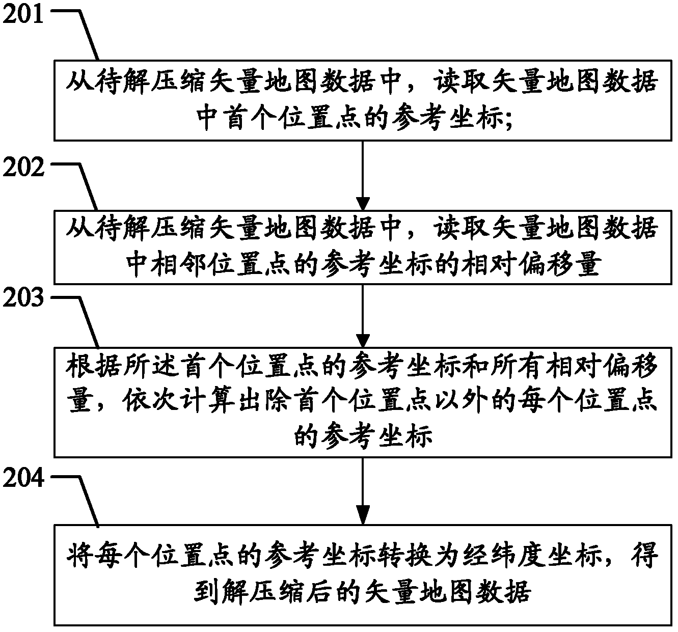
[0072] The embodiment of the present invention provides a method for vector map data decompression, such as figure 2 As shown, the method includes:
[0073] Step 201: Read the reference coordinates of the first position point in the vector map data from the vector map data to be decompressed;
[0074] Step 202: From the vector map data to be decompressed, read the relative offset of the reference coordinates of the adjacent position points in the vector map data;
[0075] Step 203: According to the reference coordinates of the first location point and all relative offsets, sequentially calculate the reference coordinates of each location point except the first location point;
[0076] It can be understood that, in step 203, after reading the reference coordinates of the first location point and the relative offset between the reference coordinates of the location points adjacent to the first location point and the reference coordinates of the first location point, the adjace...
Embodiment 3
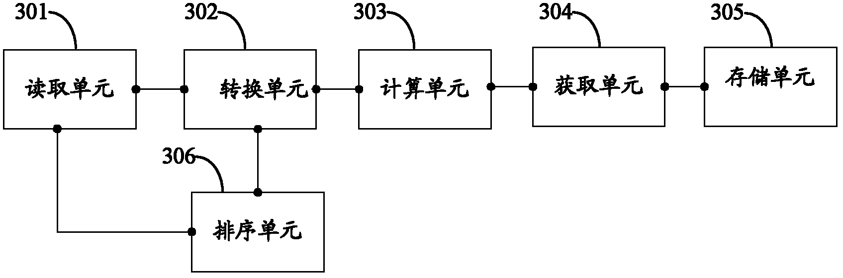
[0081] The embodiment of the present invention provides a device for compressing vector map data, such as image 3 As shown, the device includes: a reading unit 301, a conversion unit 302, a calculation unit 303, an acquisition unit 304, and a storage unit 305;
[0082] Wherein, the reading unit 301 is used to read the vector map data to be compressed;
[0083] A conversion unit 302, configured to convert the latitude and longitude coordinates of each location point in the vector map data to be compressed into reference coordinates in the set coordinate system;
[0084] Wherein, the conversion unit 302 is specifically used to multiply the latitude and longitude coordinates of each location point in the vector map data to be compressed by the preset precision parameter to obtain the high-precision coordinates of each location point in the vector map data; The high-precision coordinates of each location point are rounded to obtain the reference coordinates of the vector map dat...
PUM
 Abstract
Description
Claims
Application Information
 - R&D
- Intellectual Property
- Life Sciences
- Materials
- Tech Scout
- Unparalleled Data Quality
- Higher Quality Content
- 60% Fewer Hallucinations
Browse by: Latest US Patents, China's latest patents, Technical Efficacy Thesaurus, Application Domain, Technology Topic, Popular Technical Reports.
© 2025 PatSnap. All rights reserved.Legal|Privacy policy|Modern Slavery Act Transparency Statement|Sitemap|About US| Contact US: help@patsnap.com