Building surveying method utilizing total station and three-dimensional laser scanner

A three-dimensional laser and scanner technology, applied in the field of three-dimensional mapping of buildings, can solve problems such as non-compliance with national standards, application restrictions, and inability to reflect the real geographic information of buildings, and achieve the effect of great application value.

Inactive Publication Date: 2013-07-10
SICHUAN JIUZHOU ELECTRIC GROUP
View PDF3 Cites 55 Cited by
  • Summary
  • Abstract
  • Description
  • Claims
  • Application Information

AI Technical Summary

Problems solved by technology

[0003] The 3D laser scanner can measure the 3D coordinates of a large number of points at the same time, and has the characteristics of high precision and high speed. However, the data of each station measured by the 3D laser scanner is located in its own local coordinate system, and the spatial information is based on the machine The coordinate system cannot reflect the real geographic information of the building
In order to obtain a complete architectural model, steps such as coarse registration, fine registration, and global registration must be carried out. The selection of reference points in the process can easily cause transmission errors; and the coordinate system of the final model is still a free coordinate system, which does not conform to National standards, the application in engineering and management has been greatly restricted

Method used


Image

  • Building surveying method utilizing total station and three-dimensional laser scanner
  • Building surveying method utilizing total station and three-dimensional laser scanner
  • Building surveying method utilizing total station and three-dimensional laser scanner

Examples


Embodiment Construction

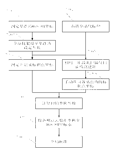
[0015] The realization step flow chart of the present invention is as figure 1 shown.

[0016] Step S101: Obtain the WGS-84 coordinates of the reference station position.

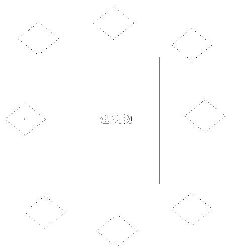
[0017] According to the measurement site conditions, set up stations around the building, such as figure 2 shown. Preferably, the site is 10m-50m away from the building to be tested. Generally, 8-10 stations are set up outdoors, and indoors are determined according to the building conditions. Select any one of the stations as the base station, and use any position in the open space as the base station, and use the receiver of the base station to select a time with good weather for continuous observation for several hours (the specific observation time depends on the site situation, the longer the observation time, the higher the accuracy ). Accurate WGS-84 coordinates of the reference station are calculated based on the observed values.

[0018] Step S102: Layout control points.

[0019] Place contr...


PUM


Abstract

The invention discloses a building surveying method utilizing a total station combined with a three-dimensional laser scanner. The method comprises the steps of: setting stations on the surrounding of a building, selecting one station as a benchmark station, and measuring the WGS-84 coordinate value of the benchmark station; arranging control points on the outer surface and the inner surface of the building, measuring and recording the coordinates of the points through the total station one by one, and scanning and measuring an obtained control point set [xi] through the three-dimensional laser scanner one by one to obtain building viewpoint cloud data, wherein a control point set [yi] is available; and realizing coarse registration on the viewpoint cloud through the [xi] and the [yi], converting the viewpoint cloud data into a WGS-84 standard coordinate system, and finally, performing global registration through the coarse registration result.

Description

technical field [0001] The invention relates to the field of three-dimensional drawing and surveying of buildings, in particular to a method for building surveying with a total station combined with a three-dimensional laser scanner. Background technique [0002] Three-dimensional surveying and mapping of buildings has a wide range of applications and needs in many fields such as civil engineering, cultural relics protection, digital cities, and virtual reality. Traditional three-dimensional surveying and mapping methods, including total station, GPS-RTK (RTK---RealTimeKinematic real-time dynamic measurement), etc., all belong to single-point measurement, and the distribution of measurement points for a single object (building, sculpture, etc.) is relatively sparse, generally the most Measuring dozens to hundreds of points is not conducive to establishing an accurate 3D model, and if more measurement points are added, the measurement efficiency cannot be guaranteed. Especia...

Claims


Application Information

Patent Timeline
Patent Type & Authority Applications(China)
IPC IPC(8): G01C7/00
Inventor 邢保振吴雨
Owner SICHUAN JIUZHOU ELECTRIC GROUP
Why Eureka
Try Eureka