Method, system and electronic device for displaying points of interest of electronic map and electronic device

An electronic map and display method technology, which is applied in the field of displaying points of interest on electronic maps, can solve problems such as the overlapping of multiple points of interest marks, and achieve the effect of convenient viewing, convenient browsing and mastering of relevant map information

Active Publication Date: 2013-07-17
TENCENT TECH (SHENZHEN) CO LTD +1
View PDF5 Cites 37 Cited by
  • Summary
  • Abstract
  • Description
  • Claims
  • Application Information

AI Technical Summary

Problems solved by technology

[0006] The purpose of the embodiments of the present invention is to provide a method for displaying multiple POIs on an electronic

Method used


Image

  • Method, system and electronic device for displaying points of interest of electronic map and electronic device
  • Method, system and electronic device for displaying points of interest of electronic map and electronic device
  • Method, system and electronic device for displaying points of interest of electronic map and electronic device

Examples


Example Embodiment

[0033] Example 1

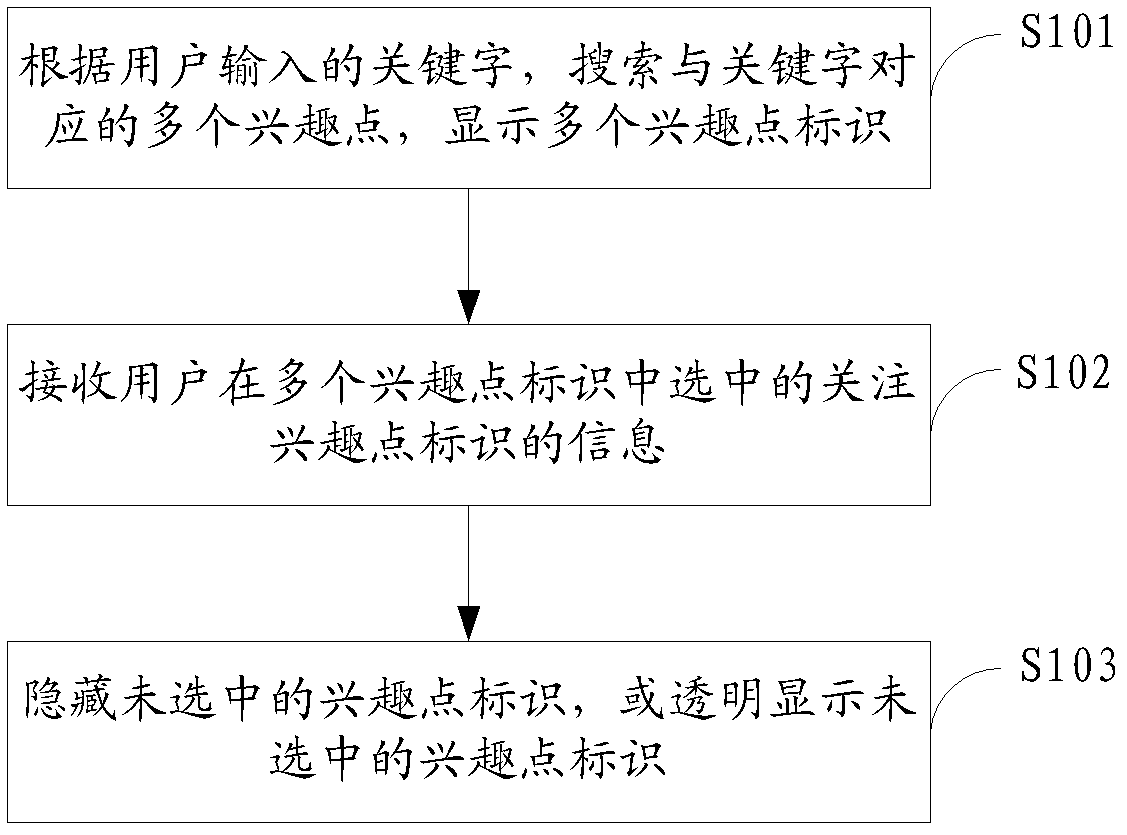
[0034] The application scenario of this embodiment is: when a user opens an electronic map to find a certain target location, the electronic map may be an electronic map on a web terminal or an electronic map on a mobile device, for example, an electronic map on a smartphone, the user will first input a query Keyword, click the search button on the electronic map to trigger the search action, the electronic map software will connect to the remote server, send a query request to the remote server, the remote server will return the points of interest that meet the query requirements to the electronic map after calculation, and the electronic map will The returned POIs are identified and displayed by means of graphics, text, etc. In order to avoid overlap between the displayed POI IDs, only the POI IDs selected by the user can be displayed, and the POI IDs not selected by the user can be hidden. The specific example is as follows: figure 1 A flow chart showi...

Example Embodiment

[0046] Embodiment 2

[0047] figure 2 A flow chart showing the implementation of the method for displaying points of interest in an electronic map provided by the second embodiment of the present invention, and the details are as follows:

[0048] In step S201, according to the keyword input by the user, multiple POIs corresponding to the keyword are searched, multiple POI identifiers are displayed, and text information corresponding to the POI is displayed in the form of a list / menu.

[0049] In this embodiment, the text information corresponding to the points of interest may be displayed in a list manner, or the text information corresponding to the points of interest may be displayed in a menu manner.

[0050] In step S202, information about the identification of the interest point of interest selected by the user from among the identifications of the multiple points of interest is received.

[0051] In step S203, the unselected POI identifiers are hidden, or the unsel...

Example Embodiment

[0059] Embodiment 3

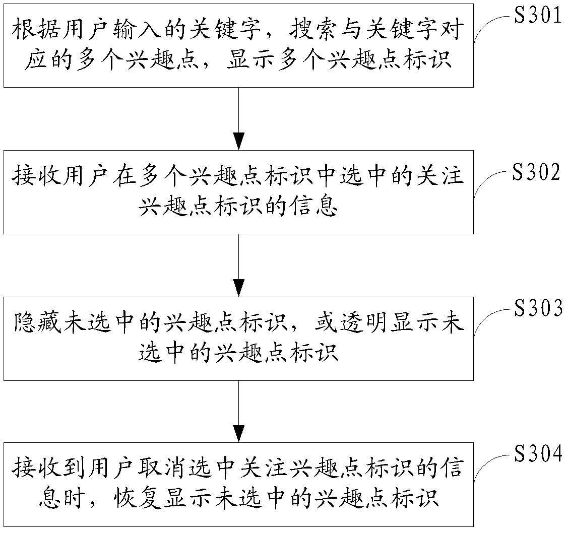
[0060] image 3 A flow chart showing the implementation of the method for displaying points of interest on an electronic map provided in Embodiment 3 of the present invention, and details are as follows:

[0061] In step S301, according to the keyword input by the user, multiple points of interest corresponding to the keyword are searched, and multiple point of interest identifiers are displayed.

[0062] In step S302, information about the identification of the interest point of interest selected by the user from among the identifications of the multiple points of interest is received.

[0063] In step S303, the unselected POI identifiers are hidden, or the unselected POI identifiers are displayed transparently.

[0064] In this embodiment, the execution of steps S301-S301 is similar to the execution process of steps S101-S103 in the above-mentioned first embodiment. For details, please refer to the description of the above-mentioned first embodiment...


PUM


Abstract

The invention is applicable to the technological field of electronic map display and provides a method, a system and an electronic device for displaying points of interest of an electronic map and an electronic device. The method comprises the steps of searching a plurality of points of interest corresponding to keywords according to the keywords input by users and displaying identification of the plurality of points of interest; receiving information of attention points of interest identification selected by the users from the plurality of identifications of points of interest; and hiding the non-selected identification of points of interest or subjecting the non-selected identification of points of interest to transparent displaying. The method, the system and the electronic device for displaying the points of interest of the electronic map effectively solves the problem of mutual blocking due to overlapping of the plurality of identifications of points of interest in a displaying process of points of interest of the electronic map, prevents the users from being affected by other points of interest while checking the attention points of interest to check base maps conveniently and surrounding terrain and landmarks visually, really facilitates the users to browse and master of relevant map information and brings unique product experience to map manufacturers who adopt the technology to be distinguished from competitors and attract more users.

Description

technical field [0001] The invention belongs to the technical field of electronic map display, and in particular relates to a method, system and electronic equipment for displaying points of interest in an electronic map. Background technique [0002] With the development of science and technology, people's quality of life is constantly improving. In order to facilitate people's travel, electronic map applications are born. In the existing electronic maps, in order to facilitate users to browse and query useful information, Point of Interest (Point of Interest) is provided. , POI) shows that each point of interest contains four aspects of information: name, category, longitude, and latitude. When a user wants to find a target location, he can input the target address on the electronic map, and the electronic map will display the corresponding point of interest. At present, there are many domestic and international electronic map search engines, such as QQ map, Sogou map, Bai...

Claims


Application Information

Patent Timeline
IPC IPC(8): G09B29/10G06F17/30
Inventor 余军
Owner TENCENT TECH (SHENZHEN) CO LTD
Why Eureka
Try Eureka