Method for improving processing efficiency of massive spatial data

A technology of spatial data and processing efficiency, applied in the direction of specific mathematical model, calculation model, calculation, etc., can solve problems such as insufficient research on spatial data operation model, algorithm, theory and method, and lack of timely application of research results. Achieve the effect of strong customizability, small parallel granularity, and improved processing efficiency

Active Publication Date: 2013-08-07
INST OF GEOGRAPHICAL SCI & NATURAL RESOURCE RES CAS
View PDF3 Cites 34 Cited by
  • Summary
  • Abstract
  • Description
  • Claims
  • Application Information

AI Technical Summary

Problems solved by technology

[0006] Generally speaking, the existing spatial data operation models, algorithms, and theories and methods are not deep enough, and the research results obtained are not realized in time for further application

Method used


Image

  • Method for improving processing efficiency of massive spatial data
  • Method for improving processing efficiency of massive spatial data
  • Method for improving processing efficiency of massive spatial data

Examples


Embodiment Construction

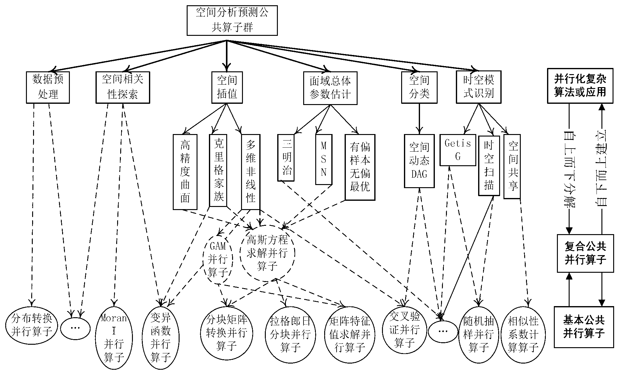
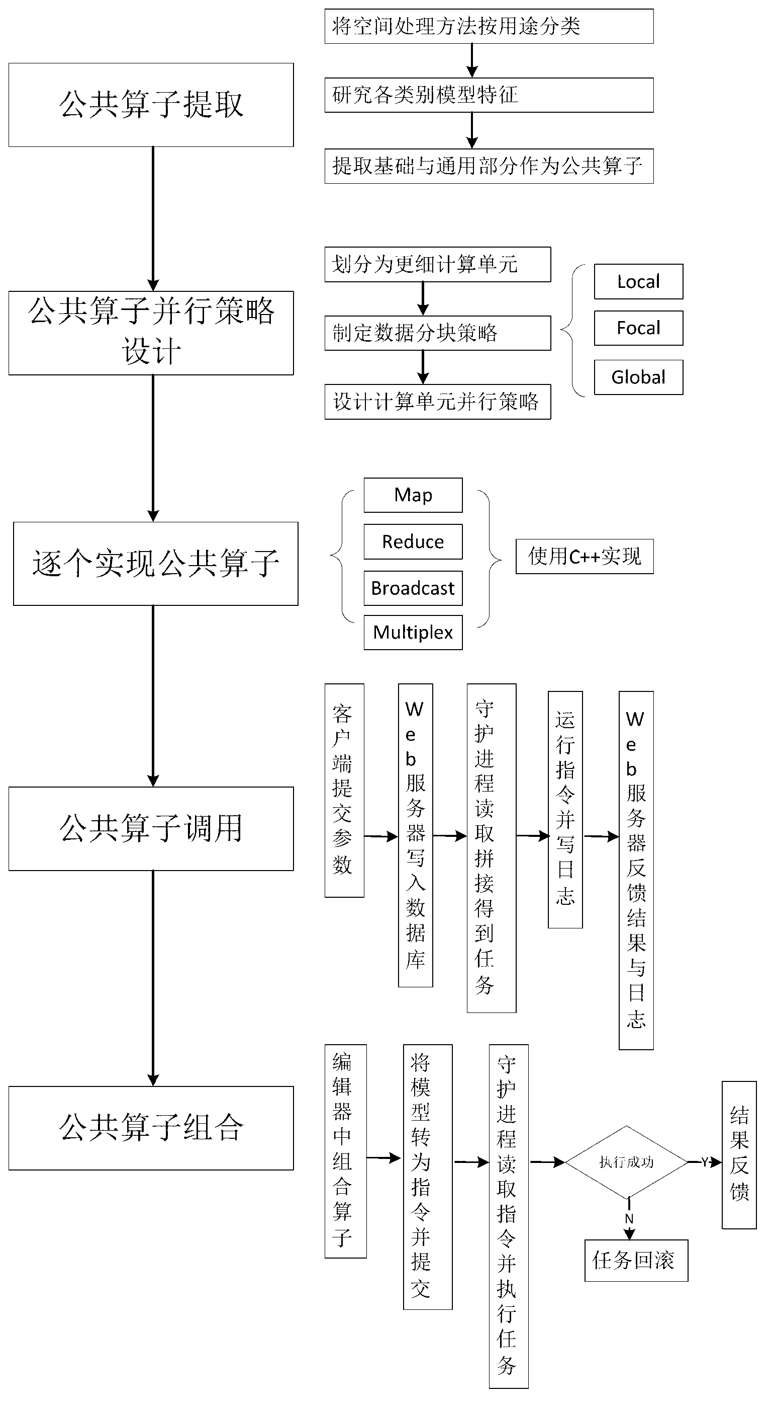
[0055] Such as figure 1 , 2 Shown, the present invention mainly comprises the following steps:

[0056] public operator extraction

[0057] Spatial data processing is generally relatively simple in terms of resource organization, and is based on the calculation of a certain type of data. In terms of algorithms, when calculating based on a certain type of attribute or graph, the calculation is relatively simple; while when doing statistical inference calculations, the complexity will be higher. In short, the more sources of resources involved, the more complex the processing of spatial data is, and the process of its realization requires the comprehensive coordination of many aspects.

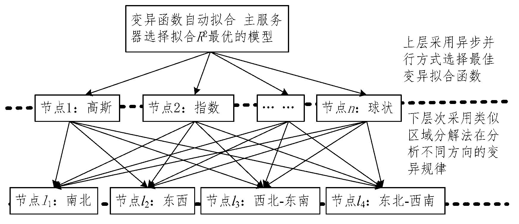
[0058] In the present invention, the spatial data processing method is divided into four parts: preprocessing, spatial feature exploration, spatial information calculation, and result inference according to the purpose. Each part contains a plurality of spatial processing models; Among them,...


PUM


Abstract

The invention provides a method for improving the processing efficiency of massive spatial data. The method comprises the following steps of: extracting a public operator, designing a public operator parallelization strategy, realizing public operator parallelization, calling the public operator, combining the public operator and the like. According to the method disclosed by the invention, a base and a common part in a spatial data processing process are used as the public operator and parallelization is carried out based on an MPI (Micro Processor Interface); the massive spatial data of millions of samples and hundreds of attributes can be processed on a data scale; an existing spatial data processing method cannot operate; meanwhile, the method can efficiently and accurately process, and job submission and parameter setting adopt a webpage to interact; and all computations are intensively and efficiently executed and finished at a server side, the pressure of a client is small and the operation is simple.

Description

technical field [0001] The invention relates to a method for improving the processing efficiency of massive spatial data based on public operators and high-performance computing. By providing a parallel computing framework for spatial data processing that can run stably and efficiently on a server, the processing efficiency of spatial data is improved, and at the same time Study how to apply spatial data processing methods to multiple fields. Background technique [0002] With the rapid development of aerospace remote sensing technology, sensor technology and the Internet, the speed and scale of obtaining spatiotemporal data continue to grow (from GB to PB), and at the same time, the number of data instances, attributes, and classifications has surged, and high-dimensional Large data sets followed. Due to the complexity of spatial data processing algorithms and the complexity of spatial information, spatial data processing of large data sets will take a lot of time. At the...

Claims


Application Information

Patent Timeline
Patent Type & Authority Applications(China)
IPC IPC(8): G06N7/00
Inventor 李连发王阳赵斯思王劲峰梁金能
Owner INST OF GEOGRAPHICAL SCI & NATURAL RESOURCE RES CAS
Why Eureka
Try Eureka