Method and system for elevation precision control and correction of island remote sensing mapping

An island and elevation technology, which is applied in the field of elevation accuracy control and correction methods and systems for remote sensing maps of islands, can solve the problems of islands falling below the sea surface and low elevation accuracy indicators

CN103245324AInactive Publication Date: 2013-08-14CHINESE ACAD OF SURVEYING & MAPPING
4 Cites 9 Cited by

Patent Information

Authority / Receiving Office
CN · China
Patent Type
Applications(China)
Current Assignee / Owner
Publication Date
2013-08-14
Estimated Expiration
Not applicable · inactive patent

Smart Images

  • Figure 1
    Figure 1
  • Figure 2
    Figure 2
  • Figure 3
    Figure 3
Patent Text Reader

Abstract

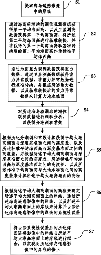
The invention discloses a method and a system for elevation precision control and correction of island remote sensing mapping, and relates to the technical field of geodetic surveying engineering. The method comprises the steps of S1, extracting shorelines from island remote sensing images; S2, obtaining a first average sea surface height and a second average sea surface height, and performing datum conversion on the second average sea surface height; S3, calculating geoidal surface; S4, carrying out harmonic analysis to obtain a tidal harmonic constant; S5, calculating elevation of mean high-water springs; S6, calculating and removing systematic errors of the shorelines in the island remote sensing images; and S7, fitting the shorelines in the island remote sensing images with the systematic errors removed and the shorelines on the mean high-water springs. Correction of the shorelines in the island remote sensing images is realized by fitting the fitting the shorelines in the island remote sensing images with the systematic errors removed and the shorelines on the mean high-water springs, thereby increasing the elevation precision obtained by the island remote sensing mapping.
Need to check novelty before this filing date? Find Prior Art

Description

technical field

[0001] The invention relates to the technical field of geodetic engineering, in particular to a method and system for controlling and correcting elevation accuracy of sea island remote sensing maps. Background technique

[0002] my country's sea area is vast, and the distribution of islands (reefs) is scattered and extremely uneven. There are more than 12,000 islands (reefs) of various types. Islands (reefs) are an important part of the national territory. Their precise location and basic geographic information are important basis for dividing territorial waters and other jurisdictional areas; comprehensively and accurately grasp the location of my country's islands (reefs) And geographic information is an important guarantee for safeguarding national sovereignty, safeguarding national security, and implementing marine development, and has important practical and far-reaching strategic significance. With the substantial improvement of spatial and spectral res...

Examples

Embodiment Construction

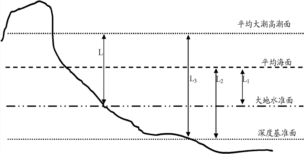
[0058] The specific implementation manners of the present invention will be further described in detail below in conjunction with the accompanying drawings and embodiments. The following examples are used to illustrate the present invention, but are not intended to limit the scope of the present invention.

[0059] figure 1 It is a flow chart of the method for controlling and correcting the elevation accuracy of remote sensing maps of sea islands according to an embodiment of the present invention. Refer to figure 1 , the method of this embodiment includes the following steps:

[0060] S1: Extract the shoreline in the remote sensing image of the island; preferably, the remote sensing image of the island includes: RapidEye-one, Alos, Spot5, IKONOS, QuickBird, WorldView-one, WorldView-Two, GeoEye-One, and low-altitude drones At least one of the obtained island remote sensing data.

[0061] S2: The first average sea surface height is obtained from the tide level observation da...