Vehicle model identification method based on high-resolution remote sensing data

A remote sensing data, high-resolution technology, applied in the field of vehicle model recognition, can solve problems such as inability to target planning and policy guidance, limited significance of traffic planning guidance, and insufficient use of vehicle context information.

Active Publication Date: 2013-09-18
WUHAN UNIV
View PDF2 Cites 17 Cited by
  • Summary
  • Abstract
  • Description
  • Claims
  • Application Information

AI Technical Summary

Problems solved by technology

[0005] 1) Most of the algorithms are focused on vehicle detection, and there are very few literatures on fine vehicle model recognition, resulting in limited guiding significance of the algorithm results for traffic planning, and it is impossible to give more targeted planning and planning for different vehicle occupancy conditions. policy guidance;
[0006] 2) The existing literature algorithms do not fully utilize the vehicle context information

Method used


Image

  • Vehicle model identification method based on high-resolution remote sensing data
  • Vehicle model identification method based on high-resolution remote sensing data
  • Vehicle model identification method based on high-resolution remote sensing data

Examples


Embodiment Construction

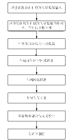
[0041]The technical solutions of the present invention will be described in detail below in conjunction with the accompanying drawings and embodiments of the present invention. In specific implementation, a single high-resolution remote sensing data can be used, or multiple high-resolution remote sensing data can be integrated for identification (including the same type of data from different satellite companies, and different types of data from the same satellite company). Such as figure 1 As shown, the implementation process of the embodiment according to the processing of multiple high-resolution remote sensing data is as follows:

[0042] For any kind of high-resolution remote sensing data, first perform steps 1 to 6:

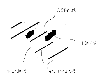
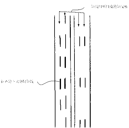
[0043] Step 1. Obtain the raster remote sensing data of the region of interest (such as roads, parking lots, etc.) containing the vehicle and the map vector data containing the region. Raster remote sensing data refers to high-resolution remote sensing im...


PUM


Abstract

A vehicle model identification method based on high-resolution remote sensing data includes acquiring raster remote sensing data including a vehicle region of interest and map vector data including the region of interest, performing rough alignment on the raster remote sensing data and the map vector data, determining a to-be-analyzed region, performing automatic extraction of center separation lines, lane or carport vacant region recognition, vehicle region detection and vehicle model identification, and outputting. On the basis of different individual analyses of the high-resolution remote sensing data, multi-source data fusion and cross validation can be performed prior to outputting. Vehicle models are automatically identified by means of priori utilizing knowledge provided by short separation lines of road centers or parking lots and integrating relevant vehicular exclusive information provided by various high-resolution remote sensing data in the context of roads or packing lots where the vehicles are located, and accordingly basic data are provided for traffic volume survey, traffic planning and the like.

Description

technical field [0001] The method belongs to the technical field of image processing and recognition, and in particular relates to a new vehicle model recognition method based on high-resolution remote sensing data. Background technique [0002] With the rapid development of space technology in various countries around the world, there are more and more high-spatial resolution remote sensing data, including QuickBird and WorldView-2 of foreign Digital Globe companies, as well as my country's resource sequence, high-scoring sequence, and environmental sequence satellites data etc. High-resolution remote sensing data provides us with high-precision spatial geometric information, rich texture information, and multispectral information of ground objects, laying the foundation for fine recognition of ground objects. The use of remote sensing high-resolution data for fine recognition of ground objects (such as vehicles) has the characteristics of convenience and speed, wide covera...

Claims


Application Information

Patent Timeline
Patent Type & Authority Applications(China)
IPC IPC(8): G06K9/00
Inventor 黄玉春
Owner WUHAN UNIV
Why Eureka
Try Eureka