Method for stimulating and displaying geological drilling information on digital earth software platform

A digital earth and software platform technology, applied in electrical digital data processing, 3D modeling, image data processing, etc., can solve the problems that limit the role of digital earth technology, and have not yet involved in the simulation and visualization of geological drilling information.

Inactive Publication Date: 2013-10-09
EAST CHINA NORMAL UNIV
View PDF5 Cites 15 Cited by
  • Summary
  • Abstract
  • Description
  • Claims
  • Application Information

AI Technical Summary

Problems solved by technology

In recent years, academic and engineering circles at home and abroad have successively carried out explorations in geophysical simulation and geological structure visualization using KML on the digital...

Method used


Image

  • Method for stimulating and displaying geological drilling information on digital earth software platform
  • Method for stimulating and displaying geological drilling information on digital earth software platform
  • Method for stimulating and displaying geological drilling information on digital earth software platform

Examples


Embodiment Construction

[0058]下面结合附图和具体实施方式对本发明作进一步详细的说明。

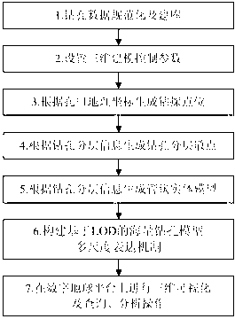
[0059]参阅图1所示,本发明首先建立一个统一的钻孔数据库标准,然后设置三维建模控制参数,接着依次生成钻探点位模型、钻孔分层散点模型和钻孔管段模型,构建基于LOD的海量钻孔模型多尺度表达机制,最后将这些模型加载到数字地球软件平台中进行可视化及查询、分析。本发明可在微机平台下采用Microsoft Visual C++语言开发实现,具体实施方式如下:

[0060]第一步钻孔数据规范化及建库

[0061]对于一个特定的研究区域,可能会有数目众多的钻孔。这些钻孔数据不仅来源多样,而且结构复杂、格式迥异。为了在数字地球软件平台上进行多源、海量钻孔信息的模拟与可视化,需要进行钻孔信息的分类、标准化及建库工作。

[0062]首先,将钻孔资料所蕴含的信息分为三类:(1)钻孔基本信息,如钻孔的名称、类别、编号、空间位置、孔口标高、地下水位、深度以及具体钻探信息;(2)地层几何结构信息,包括钻孔所揭示的各个地层的名称、序号、埋深、形成年代、地质成因、详细描述等信息;(3)地层属性参数信息,主要由钻孔所揭示的各个地层的物理、化学、水文、工程等方面的属性参数组成,如含水量、密度、饱和度、孔隙比、渗透率、泊松比、弹性模量、抗压强度、抗拉强度、抗剪强度等。在这三类信息中,钻孔基本信息和地层几何结构信息是控制钻孔的空间位置和三维几何形态最重要的数据,地层属性参数信息可视为与相应的地层相关联的属性项。为简化问题,在进行钻孔信息模拟与可视化时,本发明忽略地层属性参数信息,只考虑钻孔的基本信息和地层几何结构信息。

[0063]然后,设计四个通用的数据库表格来存储钻孔的基本信息和地层几何结构信息(表1-4)。具体包括:

[0064](1)钻孔类别表(表1)。这个表存储钻孔类别名称及其对应的代码。按照钻孔用途和钻进方式的不同,钻孔可分为不同的类别,如基岩地质钻孔、第四纪地质钻孔、水文地质钻孔、工程地质钻孔等,其中工程地质钻孔又可细分为取土孔、静探孔、标贯孔等亚类。

[0065]表1钻孔类别

[0066]

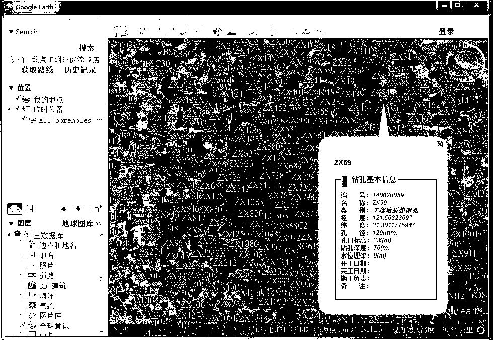
[0067](2)钻孔基本信息表(表2)。这个表中存储钻孔的编号、名称、类别、地理坐标、孔口标高、深度、地下水位、孔径、开工日期、完工日期、现场工程师等基本信息。其中"钻孔编号”是该表的关键字,可通过该字段查找到钻孔分层信息表(表3)中相应钻孔的...


PUM


Abstract

The invention discloses a method for stimulating and displaying geological drilling information on a digital earth software platform. The method includes the following steps of standardizing drill data and establishing a database, setting three-dimensional modeling control parameters, generating drilling point positions according to borehole geographical coordinates, generating drilling layered scattered points according to drilling layered information, generating a tubular solid model according to the drilling layered information, constructing huge amounts of drilling model multi-scale expression mechanisms based on LOD, and conducting three-dimensional visualization, inquiry and analysis operations on the digital earth platform. The implementation process of the method is simple and high in automaticity, the generated drilling model is rich in information, high in interaction and good in visualization effect, and distribution, integration and sharing of the generated drilling model can be easily conducted on internet. The method is beneficial to geologists for showing and distributing their drilling information to other researchers, professionals and the public.

Description

technical field [0001] The present invention relates to digital earth technology in the field of geospatial information technology, in particular to a method for simulating and displaying geological borehole information on a digital earth software platform. Various problems encountered in the process of managing, simulating, displaying, and analyzing geological drilling information on the earth software platform. Background technique [0002] In actual geological work, geological drilling is a common and important way to obtain geological information. Through drilling, not only the stratum distribution at the drilling point and the physical and mechanical indicators of rock and soil can be obtained, but also a three-dimensional solid model of the underground geological body can be constructed according to the drilling data, and the spatial distribution characteristics of the underground stratum can be reproduced in three-dimensional space And the distribution rules of its i...

Claims


Application Information

Patent Timeline
IPC IPC(8): G06F17/50G06T17/05
Inventor 朱良峰潘信王喜凤张兵李明江王子奇尤嵩
Owner EAST CHINA NORMAL UNIV
Why Eureka
Try Eureka