Stereo surveying and mapping imaging system and method based on separation load satellite formation

A satellite formation and three-dimensional surveying and mapping technology, which is applied in radio wave measurement systems, surveying and navigation, and measuring devices, can solve the problems of low-orbit separation load formation formation stability, waste of detector resources, and sampling redundancy.

Active Publication Date: 2013-10-23
NAT SPACE SCI CENT CAS
View PDF1 Cites 26 Cited by
  • Summary
  • Abstract
  • Description
  • Claims
  • Application Information

AI Technical Summary

Problems solved by technology

[0006] The purpose of the present invention is to overcome the sampling redundancy and waste of detector resources in satellite stereoscopic surveying and mapping in the prior art, and the formation stability of the low-orbit separation load formation is affected by J2 perturbation and atm...

Method used


Image

  • Stereo surveying and mapping imaging system and method based on separation load satellite formation
  • Stereo surveying and mapping imaging system and method based on separation load satellite formation
  • Stereo surveying and mapping imaging system and method based on separation load satellite formation

Examples


Embodiment Construction

[0072] The present invention will be further described now in conjunction with accompanying drawing.

[0073] Before describing the system and method of the present invention in detail, the concepts involved in the present invention will be described first.

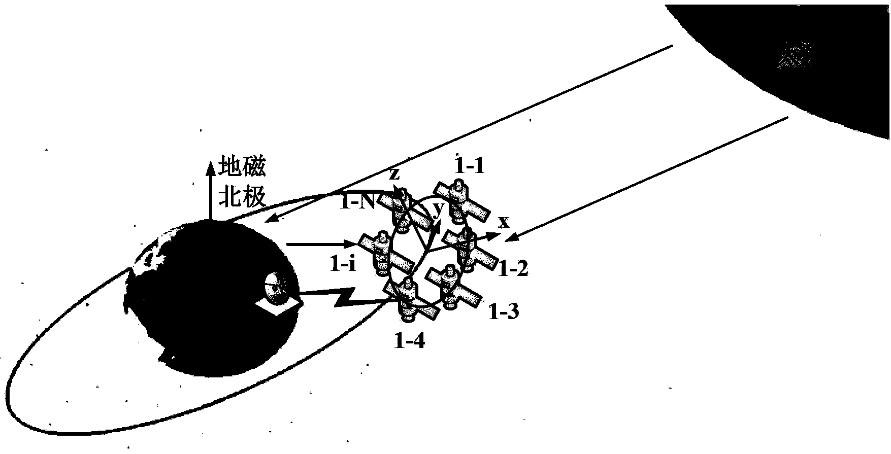
[0074] 1. Separate payload satellite formation

[0075] Due to the dense distribution of formation satellites, its overall function is still equivalent to a satellite, or it forms a large "virtual satellite", and its ground coverage characteristics are basically the same as those of a single satellite. Therefore, the single-satellite coverage analysis is done first here, and the coverage analysis of the separated payload formation is studied on the basis of the single-satellite coverage.

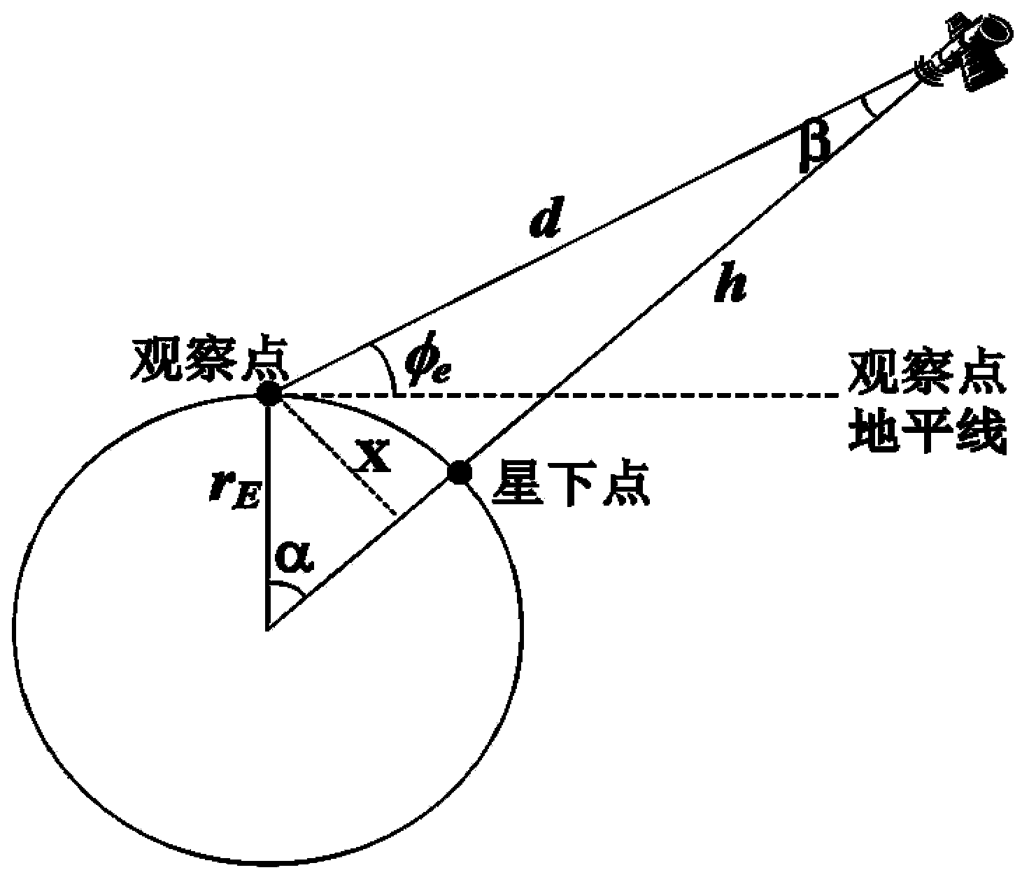
[0076] For a single satellite, the satellite coverage area refers to the range in which the radio signal sent by the satellite can be transmitted in a straight line without being reflected or rebroadcasted, that is to say, if it can be...


PUM


Abstract

The invention relates to a stereo surveying and mapping imaging system based on a separation load satellite formation. The imaging system comprises the separation load satellite formation, a satellite antenna and a ground observation station, wherein the separation load satellite formation comprises at least two satellites; each satellite comprises a satellite borne point detector; one satellite comprises an area array detector; the satellite antenna is installed on the ground observation station; sunlight comes to the surface of the globe and is reflected through the ground, the satellite borne point detectors on the various satellites receive the total light intensity in various detection directions, and a detection result is taken as a detection signal of an object arm; the area array detector detects the optical field distribution of sunlight, and a detection result is taken as a detection signal of a reference arm; the detection signals of the object arm and the reference arm are wirelessly transmitted to the ground and received by the satellite antenna; the ground observation station reconstructs a two-dimensional image observed by the various formation satellites by virtue of a compression sensing algorithm according to the received data, and then a stereo surveying and mapping image is constructed by comparing shaded area information of the images.

Description

technical field [0001] The invention relates to the field of solar light ghost imaging technology, separated payload satellite formation technology and compressed sensing theory, in particular to a three-dimensional surveying and mapping imaging system and method based on separated payload satellite formation. Background technique [0002] Correlation imaging, or ghost imaging (GI), is one of the frontiers and hotspots in the field of quantum optics in recent years. Associative imaging can generate an image of an object on an optical path that does not contain the object, and has received extensive attention as a new imaging technology. The concept of ghost imaging was first demonstrated using spatially entangled photon pairs generated by parametric down-conversion. The principle of ordinary ghost imaging is: there is an object in the optical path of the object arm, but a barrel (single-pixel) detector without spatial resolution is used for detection; there is no object in ...

Claims


Application Information

Patent Timeline
IPC IPC(8): G01C11/00G01S17/89
Inventor 俞文凯孙志斌李明涛雷博持姚旭日刘雪峰郑建华翟光杰杨震孟新
Owner NAT SPACE SCI CENT CAS
Why Eureka
Try Eureka