
Field geological information collection system, collection method and application method of collection system

A technology of information collection and geology, which is applied in the field of field geological information collection system, can solve the problems of inconvenient sorting, application, heavy workload of internal data processing, and multiple data types, so as to improve efficiency and data accuracy, and ensure original The authenticity of the system and the effect of a wide range of applicable platforms

Active Publication Date: 2016-07-06
长江岩土工程有限公司
View PDF2 Cites 0 Cited by
  • Summary
  • Abstract
  • Description
  • Claims
  • Application Information

AI Technical Summary

Problems solved by technology

There are many advantages in using PDA for field data collection, but there are also some shortcomings: first, the positioning accuracy is not high, and the positioning accuracy of ordinary handheld and built-in GPS can only be roughly positioned, which cannot meet the accuracy requirements of current field geological information collection; However, due to the complexity of field geological information, it is difficult to clearly and completely express only through simple text records, and the collected data is incomplete. Third, the collected field geological information is basically in a decentralized and non-dynamic management state, and the workload of post-office data processing is still relatively large, with many types of data and messy formats, which is not convenient for post-organization and analysis, and cannot be done very quickly. Satisfying the development needs of engineering geological work in the new period well
[0005] Traditional field geological information collection has a large workload, is difficult to store, and is difficult to use. There is a huge duplication of labor, and the work cycle is long, resulting in a lot of waste of manpower and material resources.
The use of PDA can reduce some post-office work, but it is generally limited to the entry of simple text data. The collected geological carrier information is not comprehensive enough, and the information is scattered, which is not convenient for post-organization and application.

Method used


Image

  • Field geological information collection system, collection method and application method of collection system
  • Field geological information collection system, collection method and application method of collection system
  • Field geological information collection system, collection method and application method of collection system

Examples


Embodiment Construction

[0048] Below in conjunction with accompanying drawing and specific embodiment the present invention is described in further detail:

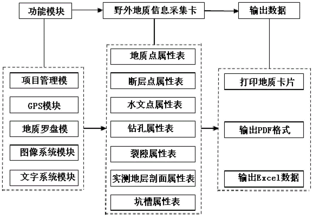
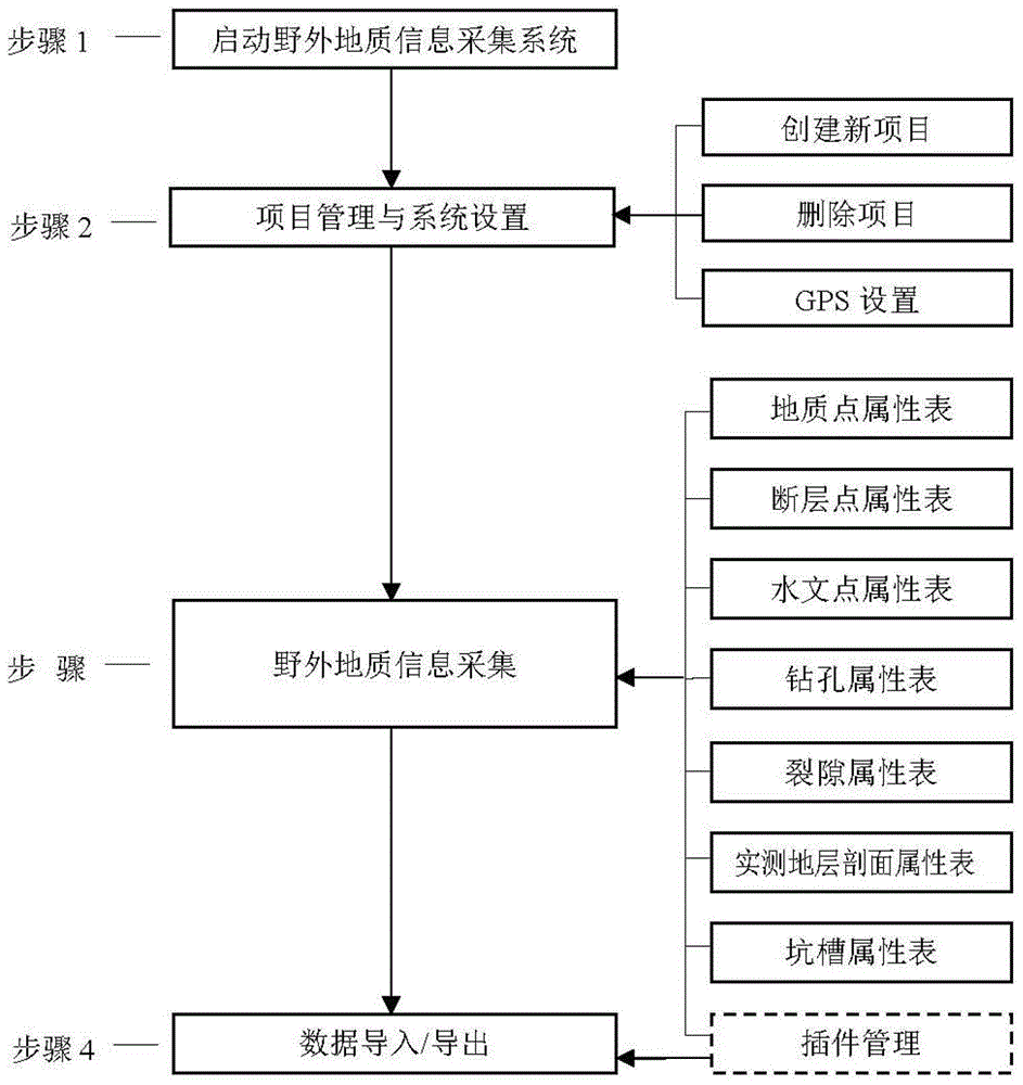
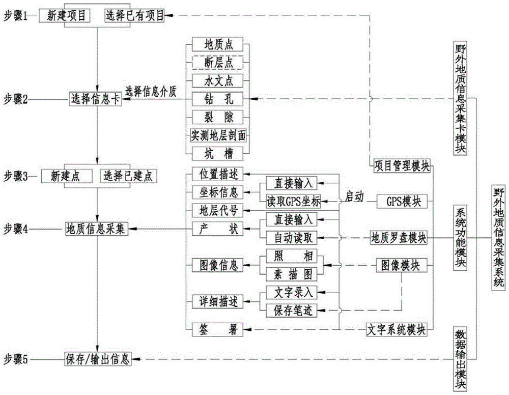
[0049] like figure 1 As shown, the present invention adopts the "platform" thought design, integrates project management module, GPS module, geological compass module, image system module, and text system module, and divides field geological sources into points, lines, and planes for collection, and Geological points, fault points, hydrological points, boreholes, fractures, measured stratigraphic profiles, pits and other geological medium sources are output in the form of field geological information acquisition card modules and Excel data files, which not only meets the requirements of original data archiving It also realizes the direct use of field geological information and integrates outdoor and indoor work.

[0050] The project management module contained in the present invention is used to create one or more projects and manage various ge...


PUM


Abstract

The invention relates to a geologic field information collection system. The collection system is designed by adopting a platform-based concept and integrates a project management module, a GPS (global positioning system) module, a geologic compass module, an image system module and a character system module, collection is performed by dividing geologic field sources into points, lines and planes, and information of geologic medium sources like geologic points, fault points, hydrologic points, drill holes, fractures, measured formation sections and pits is output in the form of geologic field information collection card module pieces and Excel data files respectively, so that requirements on filing of original data are met, direct utilization of geologic field information is realized, and integration of outdoor work and indoor work is realized. The collection system comprises a system function module, a geologic field information collection card module and a data output module. By the system, the geologic field information can be collected quickly and accurately; efficiency of field work and data accuracy are improved by providing functions of quick GPS positioning, a measuring ruler, an angulometer, a geologic compass and the like.

Description

technical field [0001] The invention relates to a field geological information collection system, a collection method and an application method of the collection system, and relates to the fields of electronic information and engineering geology. Background technique [0002] Today's society is known as the "Information Age", and the efficient use of digital information has led to high-efficiency productivity and rapid social and economic development. The rapid economic development has put forward higher requirements for geological work, especially the higher and higher requirements for the accuracy and efficiency of field geological information collection. [0003] Traditional field geological information collection is mainly through handwritten records in field notebooks. Geological engineers need to analyze, sort out, measure, and record field geological information such as geological points, hydrogeological points, drill hole catalog data, and various geological phenomen...

Claims


Application Information

Patent Timeline
Patent Type & Authority Patents(China)
IPC IPC(8): G06F17/40
Inventor 郭麒麟冯明权马贵生向能武杨汉良赵旻陈文理孙云志石林易名龙苏小宁殷先松雷世兵刘丽冯建元贾进科冯建伟巫玉皇韩旭张必勇刘海峰李小龙
Owner 长江岩土工程有限公司
Learn More