Digital-earth-oriented data fusion method and device

A digital earth and data fusion technology, applied in the field of geographic information, can solve problems such as DEM fusion errors, sudden changes in terrain, discontinuous visual interfaces, etc., and achieve the effect of improving local mutations and discontinuous images, and improving the degree of fusion

Active Publication Date: 2013-12-04
CHINA TOPRS TECH
View PDF3 Cites 15 Cited by
  • Summary
  • Abstract
  • Description
  • Claims
  • Application Information

AI Technical Summary

Problems solved by technology

[0003] However, when the high-precision DEM data is added to the digital earth platform, due to the difference in data accuracy, it will cause fusion errors between the high-prec...

Method used


Image

  • Digital-earth-oriented data fusion method and device
  • Digital-earth-oriented data fusion method and device
  • Digital-earth-oriented data fusion method and device

Examples


Embodiment Construction

[0048] The present invention will be described in further detail below through specific implementation examples and in conjunction with the accompanying drawings.

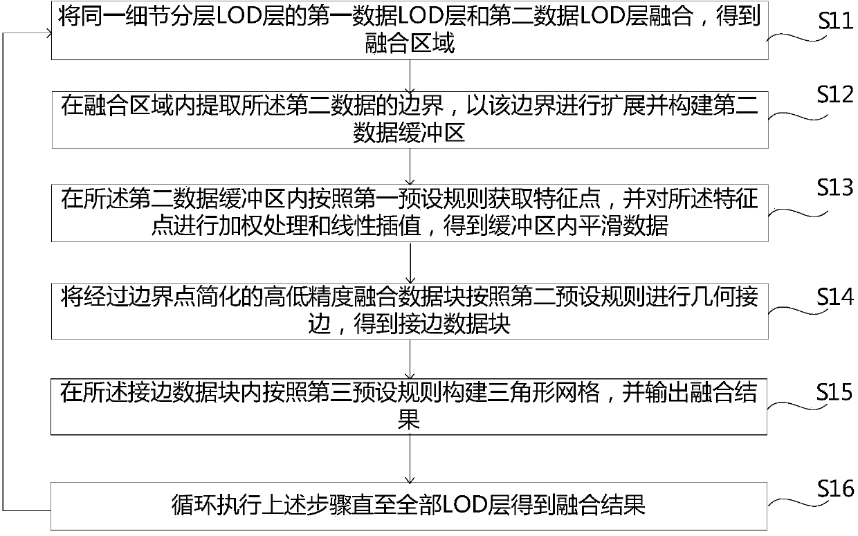
[0049] figure 1 A digital earth-oriented data fusion method is shown, including:

[0050] S11: merging the first data LOD layer and the second data LOD layer of the same detail layered LOD layer to obtain the fusion area, the first data is the low-precision digital elevation model DEM data in the digital earth platform database, and the second The second data is local high-precision DEM data;

[0051] In this step, the low-precision DEM data in the digital earth database are layered and divided into blocks, and the first discrete LOD quadtree model is constructed, and the local high-precision DEM data are layered into blocks, and the second discrete LOD quadtree model is constructed. . The high-precision DEM data LOD layer is fused with the corresponding low-precision DEM data LOD layer.

[0052] It should be n...


PUM


Abstract

The invention relates to the technical field of geographic information, in particular to a digital-earth-oriented data fusion method and device. The digital-earth-oriented data fusion method comprises the following steps that a first data LOD layer and a second data LOD layer of the same level of detail LOD layer are fused, so that a fusion area is obtained; the border of second data is extracted in the fusion area, expansion is conducted based on the border, and a second data buffer area is established; feature points are obtained according to the first preset rule in the second data buffer area, and smooth data in the buffer area are obtained through weighting processing and linear interpolation; according to the second preset rule, geometric border matching is conducted on high-precision and low-precision fusion data blocks which are simplified through border points, so that a border matching data block is obtained; a triangular network is established in the border matching data block according to the third preset rule, and a fusion result is output; the steps are executed in a circulating mode until all LOD layers obtain fusion results. The digital-earth-oriented data fusion method and device solve the problems that local abrupt change occurs and frames are not continuous in the digital earth visualization process.

Description

technical field [0001] The present invention relates to the technical field of geographic information, more specifically, to a digital earth-oriented data fusion method and device. Background technique [0002] On the Digital Earth platform, its terrain data is expressed by means of a digital elevation model (Digital Elevation Model, DEM is a terrain model that expresses ground elevation in the form of a set of ordered numerical arrays), through LOD layering, four-dimensional Fork tree block global subdivision to build the skeleton. How to use the new high-precision DEM data to update the original DEM data of the Digital Earth platform is of great significance to improve the detailed level of the terrain and reflect the spatial entity of the terrain more accurately. [0003] However, when the high-precision DEM data is added to the digital earth platform, the fusion error between the high-precision DEM and the original DEM in the digital earth platform will be caused due to...

Claims


Application Information

Patent Timeline
IPC IPC(8): G06F17/30
Inventor 李英成王恩泉胡特彧肖金城刘慧杰
Owner CHINA TOPRS TECH
Why Eureka
Try Eureka