Grid division system and method for emergency early warning based on hybrid spatial correlation analysis

A technology of spatial relationship and grid division, which is used in data processing applications, instruments, calculations, etc.

Inactive Publication Date: 2016-07-06
SHANGHAI JIAOTONG UNIV
View PDF4 Cites 0 Cited by
  • Summary
  • Abstract
  • Description
  • Claims
  • Application Information

AI Technical Summary

Problems solved by technology

However, this technology does not involve the impact of geospatial information on disaster events, and does not conduct in-depth analysis of the occurrence, evolution, rescue and recovery of emergency events affected by geographic information. The use of GIS platform only plays the role of visualization of geospatial information.

Method used


Image

  • Grid division system and method for emergency early warning based on hybrid spatial correlation analysis
  • Grid division system and method for emergency early warning based on hybrid spatial correlation analysis
  • Grid division system and method for emergency early warning based on hybrid spatial correlation analysis

Examples


Embodiment 1

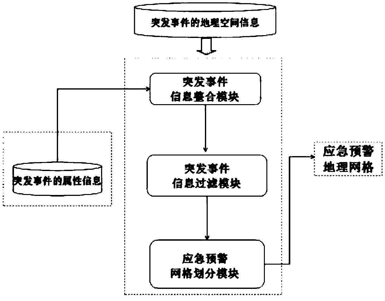
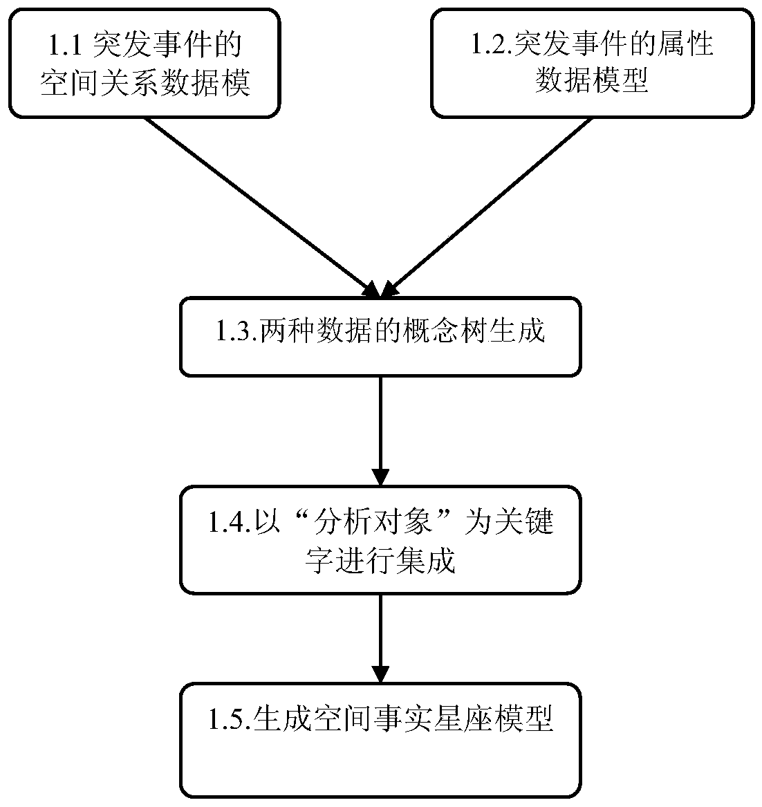
[0029] like figure 1 As shown, the present embodiment includes: an emergency event information integration module, an emergency event information filtering module and an emergency early warning grid division module, wherein: the emergency event information integration module receives the emergency geographic information from the GIS database and from the relationship Emergency event attribute information of type data, and generate spatial relationship information according to GIS data processing, and output spatial relationship information and event attributes to the emergency event information filtering module after integrating the spatial fact constellation model according to keywords, and emergency event information filtering The module filters and preprocesses the spatial fact constellation model according to the distribution difference of spatial information and outputs the processed spatial fact constellation model to the emergency warning grid division module. Constella...


PUM


Abstract

An emergency early warning grid division system and method based on spatial correlation analysis in the field of Internet disaster early warning technology, the system includes: an emergency event information integration module, an emergency event information filtering module and an emergency early warning grid division module. In this method, the geographical information of emergencies is used as the analysis clue of emergency early warning layout, and the expression mode of emergency spatial relationship information is firstly designed; then, the spatial relationship information of emergencies is extracted and integrated with the structural attribute information of emergencies Integrate and establish a constellation model of spatial facts; then filter out meaningless spatial relationship information according to the filtering algorithm based on frequency difference; finally, through the mining of hybrid spatial association rules, the spatial characteristics of the impacting events are obtained, and the composition covers different emergency warning levels emergency warning geographic grid. The present invention realizes the integration of the spatial relationship information and attribute information around the emergency, uses the concept tree to describe the spatial relationship information and event attribute information, and realizes the spatial fact constellation model that integrates the unstructured data and structured data of the emergency .

Description

technical field [0001] The present invention relates to a method and device in the technical field of Internet disaster early warning, in particular to an emergency early warning grid division system and method based on spatial correlation analysis. Background technique [0002] Since emergency emergencies occur in a specific geographic space, the early warning, mid-event response, and post-event recovery of disaster emergencies can all be managed and planned with the support of geographic information systems. There are many academic literatures on this research, of which there are two representative types: The first type is the technical application of geographic information system (GIS) in early warning and decision-making of disasters. For example, use geographic information system to visualize the area distribution of chemical pollution on the river bank, and then use the trend evolution model to carry out decision-making evaluation (Jiangetal., 2012); based on the elect...

Claims


Application Information

Patent Timeline
Patent Type & Authority Patents(China)
IPC IPC(8): G06Q10/00G06Q50/26
Inventor 樊博
Owner SHANGHAI JIAOTONG UNIV
Why Eureka
Try Eureka