Vehicle location system based on space-time coding

A technology of space-time coding and vehicle positioning, which is applied in the field of vehicle positioning system based on space-time coding, can solve problems such as data transmission security, and achieve the effect of simple transmission content

Inactive Publication Date: 2014-01-01
中交北斗技术有限责任公司
View PDF7 Cites 3 Cited by
  • Summary
  • Abstract
  • Description
  • Claims
  • Application Information

AI Technical Summary

Problems solved by technology

But while the positioning system is widely used, we are also facing such a problem: the security of data transmission

Method used


Image

  • Vehicle location system based on space-time coding
  • Vehicle location system based on space-time coding

Examples


Embodiment Construction

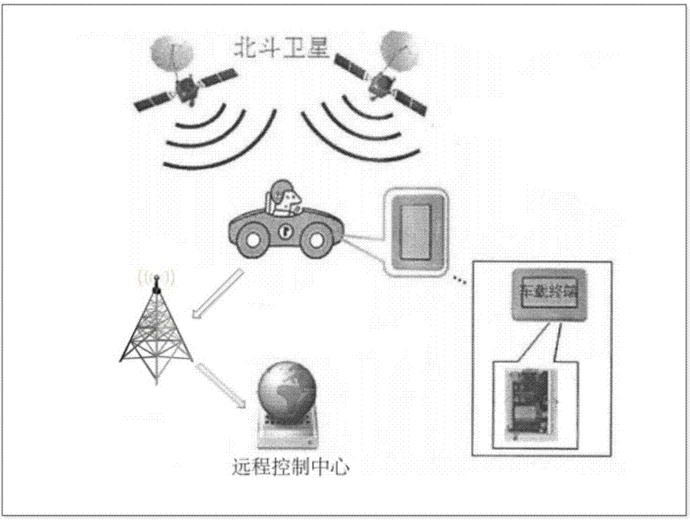
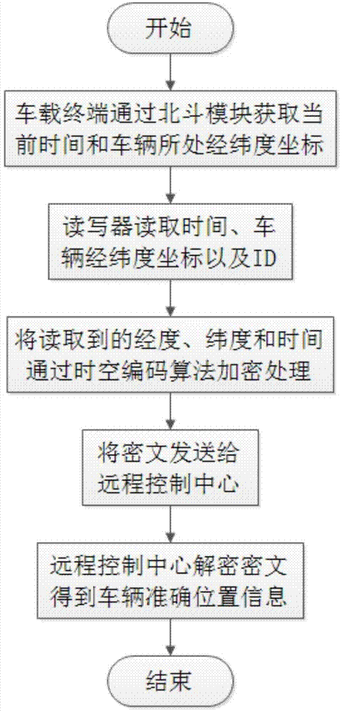
[0009] The present invention provides a vehicle positioning system based on space-time coding, which includes a passive vehicle terminal, a reader and a remote control center; There is a Beidou module in the middle, which can obtain the current time and the latitude and longitude in real time; the RFID tag reader is set on the road, and when the vehicle equipped with the passive vehicle terminal enters the effective reading range of the reader, the RFID tag reader will Read and read its ID and receive the time and accurate coordinates transmitted by the Beidou satellite, and form the time-space code with the received time, longitude and latitude, and calculate the vehicle ID and time-space code every time T through the wireless network. The encrypted information is transmitted to the remote monitoring center, and then the control center decrypts and checks the relevant information.

[0010] The RFID tag reader communicates with the remote control center through a wireless netw...


PUM


Abstract

The invention discloses a vehicle location system based on space-time coding. The vehicle location system comprises a passive vehicle-mounted terminal, an RFID tag reader and a remote control center. The passive vehicle-mounted terminal is arranged on a vehicle, and comprises only one ID. Meanwhile, the terminal is provided with a Beidou module, and the Beidou module is used for obtaining the current time and the longitude and latitude where the Beidou module is located in a real-time mode. The RFID tag reader is arranged on a road, when a vehicle provided with the passive vehicle-mounted terminal enters the effective reading range of the RFID tag reader, the RFID tag reader conducts reading, reads the ID of the vehicle and receives time and the coordinate transmitted by a Beidou satellite, space-time codes are formed by the received time, the longitude and latitude, and the ID of the vehicle and the space-time codes obtained by the statistics are transmitted to the remote control center at regular intervals T through a wireless network in an enciphered-message mode. According to the system, any changes are not required to be conducted on the infrastructure construction of the road, and the aim can be achieved only by installing a radio frequency reader-writer.

Description

technical field [0001] The invention relates to a vehicle positioning system, in particular to a vehicle positioning system based on space-time coding. Background technique [0002] With the rapid development of intelligent transportation systems, vehicle positioning and navigation systems are also developing. Nowadays, Global Positioning System (GPS) and Dead Position Navigation System (DR) are mainly used for vehicle positioning, which ensures the need for global, all-weather continuous real-time positioning. But while the positioning system is widely used, we are also facing such a problem: the security of data transmission. Contents of the invention [0003] The technical problem to be solved by the present invention is to provide a vehicle positioning system based on space-time coding, including a passive vehicle terminal, an RFID tag reader and a remote control center, the passive vehicle terminal is arranged on the vehicle, and the above passive The vehicle-mounte...

Claims


Application Information

Patent Timeline
Patent Type & Authority Applications(China)
IPC IPC(8): G08G1/123G01S19/14
Inventor 王杨安锡文陈昊
Owner 中交北斗技术有限责任公司
Why Eureka
Try Eureka