High-precision attitude data calculation method for AHRS (Attitude and Heading Reference System)

A data calculation and high-precision technology, applied in navigation calculation tools and other directions, can solve problems such as large errors in attitude data, limited accuracy of accelerometers and gyroscopes, etc.

Inactive Publication Date: 2014-01-08
成都市星达通科技有限公司
View PDF3 Cites 17 Cited by
  • Summary
  • Abstract
  • Description
  • Claims
  • Application Information

AI Technical Summary

Problems solved by technology

[0003] The purpose of the present invention is to provide a method for calculating AHRS high-precision attitude data, which mainly solves the problem in the prior art that the accuracy of accelerometers and gyroscopes is limited and there are cumulative errors, so the resulting attitude data has large errors and cannot Meeting technical needs

Method used


Image

  • High-precision attitude data calculation method for AHRS (Attitude and Heading Reference System)
  • High-precision attitude data calculation method for AHRS (Attitude and Heading Reference System)
  • High-precision attitude data calculation method for AHRS (Attitude and Heading Reference System)

Examples


Embodiment

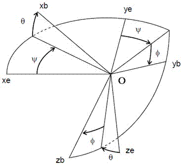
[0046] In order to solve the problems existing in the prior art due to the limited accuracy of the accelerometer and gyroscope and the cumulative error, the obtained attitude data has a large error and cannot meet the technical requirements, such as figure 1 As shown, two different coordinate systems are adopted in the present invention: the ground coordinate system (also called the northeast sky coordinate system) and the carrier coordinate system.

[0047] The ground coordinate system means that within a relatively short distance from the earth's surface (such as within tens of kilometers), the geodetic level can be regarded as a plane, so that the east direction can be regarded as the positive x axis, and the true north direction can be regarded as the positive half of y. Axis, perpendicular to the ground upwards is the z positive semi-axis, which constitutes the ground coordinate system, which is the so-called northeast sky coordinate system;

[0048] The carrier coordinat...


PUM


Abstract

The invention discloses a high-precision attitude data calculation method for an AHRS (Attitude and Heading Reference System), mainly solving the problems that as an accelerometer and a gyroscope are finite in precisions and have accumulative errors, the obtained attitude data errors are large and cannot meet technical requirements in the prior art. The high-precision attitude data calculation method comprises the following steps of initializing a sensor and a normalized coordinate system transfer matrix; calculating the attitude data and the coordinate system transfer matrix R1 of a carrier at the moment; calculating a coordinate system transfer matrix R2 at the moment; determining a final coordinate system transfer matrix at the moment, and normalizing the final coordinate system transfer matrix, so as to obtain the normalized coordinate system transfer matrix at the moment; solving the attitude data at the moment according to the normalized coordinate system transfer matrix obtained in the step (4); and returning to the step (2), and calculating the attitude data of the next moment. By utilizing the scheme, the high-precision attitude data calculation method is convenient to implement, is high in precision and has very high practical and promotional values.

Description

technical field [0001] The invention relates to a method for calculating attitude data in the field of navigation, in particular to a method for calculating AHRS high-precision attitude data. Background technique [0002] As we all know, inertial navigation mainly involves two aspects: positioning and attitude determination. Positioning can be completed through global satellite positioning systems (such as GPS, Beidou, etc.); The angular velocity information is calculated by integral to obtain the current attitude data (mainly including direction angle, pitch angle and roll angle). Due to the limited accuracy of the accelerometer and gyroscope and the cumulative error, the obtained attitude data has a large error and cannot meet the technical requirements. Contents of the invention [0003] The purpose of the present invention is to provide a method for calculating AHRS high-precision attitude data, which mainly solves the problem in the prior art that the accuracy of acc...

Claims


Application Information

Patent Timeline
Patent Type & Authority Applications(China)
IPC IPC(8): G01C21/20
CPCG01C21/20
Inventor 李玉柏王坚李桓
Owner 成都市星达通科技有限公司
Why Eureka
Try Eureka