
Efficient spatial nearest neighbor query method for highway networks

A query method and nearest-neighbor technology, applied in special data processing applications, instruments, electrical digital data processing, etc., can solve problems such as large query time and increased overhead

Active Publication Date: 2014-02-05
HENAN UNIVERSITY
View PDF4 Cites 9 Cited by
  • Summary
  • Abstract
  • Description
  • Claims
  • Application Information

AI Technical Summary

Problems solved by technology

The time complexity of using this type of index to search the neighborhood of the query point in the road network is O(log N), where N is the total number of sub-segments, which will take a lot of query time; and, to find the query point in the road network After the neighborhood of , the existing methods have to look at the candidate data objects on all sub-segments in the neighborhood, and need to scan the index on the road network and calculate the shortest path and its length from the query point to each candidate object, which further increases computational overhead

Method used


Image

  • Efficient spatial nearest neighbor query method for highway networks
  • Efficient spatial nearest neighbor query method for highway networks
  • Efficient spatial nearest neighbor query method for highway networks

Examples


Embodiment Construction

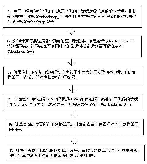
[0042] like figure 1 As shown, the highway network efficient spatial nearest neighbor query method of the present invention comprises the following steps, wherein A, B, C, and D steps are used in the offline index building stage; E, F steps are used in the real-time spatial query processing stage:

[0043] A: The user provides input data including road network information and data object information on the road network, creates a hash table hashmap_1 based on the input data, and stores the correspondence between all data objects and their coordinate values ​​in the hash table hashmap_1; the hash table The primary key of hashmap_1 is the unique identifier oid of the data object, and the value is the coordinate value of the data object.

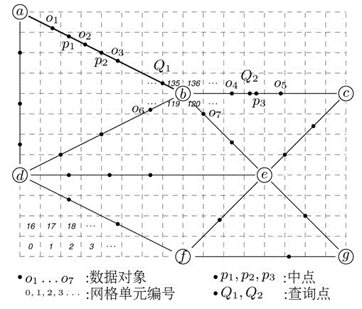
[0044] B: Calculate the spatial nearest neighbors of each vertex of each road, create a hash table hashmap_2, and store the road vertex, the nearest neighbor and the nearest distance of the vertex on the spatial network in the hash table hashma...


PUM


Abstract

The invention discloses an efficient spatial nearest neighbor query method for highway networks. The method includes the steps of A, storing all data objects and correspondences of coordinates thereof in a Hash table 1; B, calculating spatial nearest neighbors of apexes of a highway, and storing the highway apexes, the nearest neighbors and nearest distances into a Hash table 2; C, dividing a two-dimensional space into a plurality of grid units by a virtual grid, and numbering the grid units; D, calculating and storing correspondences between the grid units and the data objects or highway apexes, and storing the correspondences into a Hash table 3; E, calculating the grid units where query points locate and determining numbers of the grid units; F, searching for the data objects that the grid units correspond to, and calculating the nearest data objects and returning the nearest data objects to users. The method has the advantages that time complexity in spatial nearest neighbor query for highway networks can be reduced, query efficiency is improved greatly, and neighbor query time is shortened.

Description

technical field [0001] The invention relates to a space nearest neighbor query method, in particular to a high-efficiency space nearest neighbor query method for a road network. Background technique [0002] In recent years, with the popularity of smart phones, people are increasingly using mobile phones to locate, search, browse and share information; more and more facilities such as restaurants, shops, cinemas, etc. map to obtain. This service based on geographic location information for smart phone users has been widely accepted by people. Moreover, with the development of information technology, there are more and more applications and services based on geographic location information. [0003] Among these applications and services, a relatively common service based on geographic location information is to search for facilities near the user's current location that satisfy keywords defined by the user. In such applications, how to efficiently process the spatial query...

Claims


Application Information

Patent Timeline
IPC IPC(8): G06F17/30
CPCG06F16/29G06F16/9537
Inventor 张重生
Owner HENAN UNIVERSITY
Features
  • Generate Ideas
  • Intellectual Property
  • Life Sciences
  • Materials
  • Tech Scout
  • Unparalleled Data Quality
  • Higher Quality Content
  • 60% Fewer Hallucinations
Learn More