Ground-based broadcasting type locating method

A positioning method and broadcast technology, which is applied in the field of high-precision positioning based on the broadcast method of ground-based reference stations, can solve problems such as the influence of aircraft positioning accuracy, and achieve the effects of strong signal anti-interference performance, high positioning accuracy, and easy implementation.

Inactive Publication Date: 2014-03-26
FLIGHT INSPECTION CENT OF CAAC
View PDF4 Cites 3 Cited by
  • Summary
  • Abstract
  • Description
  • Claims
  • Application Information

AI Technical Summary

Problems solved by technology

[0012] Aiming at the problem that the positioning accuracy of the aircraft is affected by using the prior art in a specific environment or under unfavorable geographical conditions, the present invention proposes a ground-based broadcast positioning method to realize high-precision positioning of the aircraft

Method used


Image

  • Ground-based broadcasting type locating method
  • Ground-based broadcasting type locating method
  • Ground-based broadcasting type locating method

Examples


Embodiment Construction

[0024] The present invention will be further described in detail with reference to the accompanying drawings and embodiments.

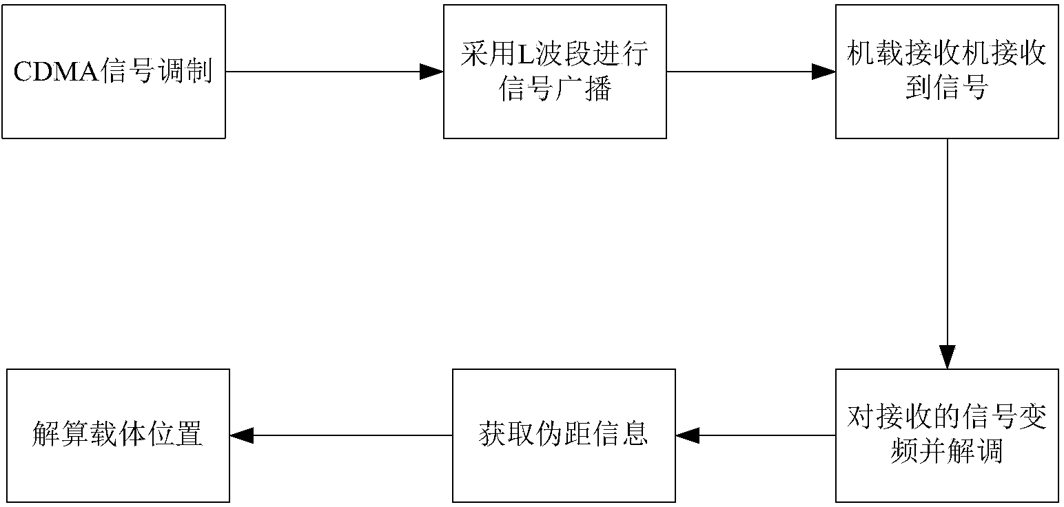
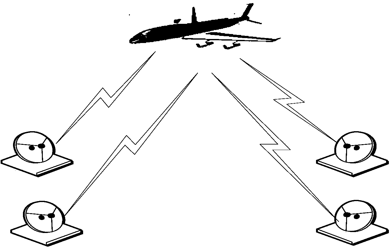
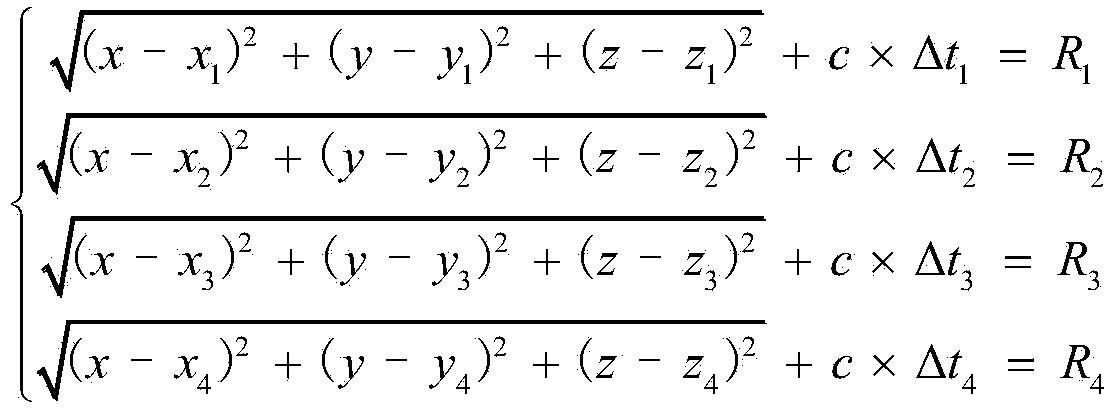
[0025] The ground-based broadcast positioning method of the present invention is that the ground-based broadcast station uses the station's identification code (pre-embedded), high-precision longitude, latitude, elevation (after surveying and mapping, pre-embedded data) and clock information (along with the internal clock Generate), and continue to transmit after code division multiple access modulation. The L-band is used to transmit to the airborne receiver of the aircraft. The airborne receiver receives the information sent by the ground reference station, and converts and demodulates the information to obtain the identification code, longitude and latitude contained in the information sent by the ground-based broadcasting station. and clock information. By comparing the time when the airborne receiver receives the signal with the clock informatio...


PUM


Abstract

The invention discloses a ground-based broadcasting type locating method. Ground-based broadcasting stations are built in a located area, code division multiple access modulation is carried out on information of identification codes, the longitude, the latitude, the elevation and the clock of the ground-based broadcasting stations, the ground-based broadcasting stations continuously send the processed information of the identification codes, the longitude, the latitude, the elevation and the clock of the ground-based broadcasting stations, the information is transmitted to an onboard receiver of an aircraft through an L band, and the onboard receiver receives the information sent by the ground-based broadcasting stations, and carries out frequency conversion and demodulation on the information to obtain the identification codes, the longitude, the latitude and the clock, wherein the identification codes, the longitude, the latitude and the clock are contained in the information sent by the ground-based broadcasting stations; comparison between the signal receiving moment of the onboard receiver and the information, obtained through demodulation, of the clock is carried out, the distance between the aircraft and the corresponding ground-based broadcasting station is calculated, and then the position of the aircraft is obtained through calculation. According to the ground-based broadcasting type locating method, anti-interference performance of signals is good, accurate locating and accurate navigation of the aircraft can be achieved, and the ground-based broadcasting type locating method has the advantages of being all-weather, high in accuracy, low in cost, easy to achieve, good in real-time performance, multipurpose and the like.

Description

technical field [0001] The invention belongs to the field of aircraft space positioning and navigation, in particular to a high-precision positioning method based on the broadcast mode of ground-based reference stations. Background technique [0002] For aircraft, whether it is ground-based navigation or air-based navigation, its basic task is to provide real-time spatial position and guidance information for the aircraft. [0003] With the development of navigation technology to this day, various positioning and navigation methods and systems have been produced. Currently the most widely used positioning and navigation methods in the aviation field are: Inertial Navigation (INS) and GPS (Global Positioning System) navigation. Both have different positioning principles and their own advantages and disadvantages. [0004] 1. Inertial navigation technology: [0005] Inertial navigation is an advanced autonomous navigation method. Its principle of navigation and positioning ...

Claims


Application Information

Patent Timeline
Patent Type & Authority Applications(China)
IPC IPC(8): H04W64/00
Inventor 葛茂
Owner FLIGHT INSPECTION CENT OF CAAC
Why Eureka
Try Eureka