Attitude adjustment and nonlinear calibration method for imaging in identical region of heterogeneous scene

A non-uniform scene, nonlinear technology, applied in the field of remote sensing satellite calibration, can solve the problems of device changes, affecting the calibration frequency, difficult to achieve high-precision nonlinear calibration, etc., to avoid unreliability and ensure effectiveness. Effect

Inactive Publication Date: 2014-05-07
CHINA ACADEMY OF SPACE TECHNOLOGY
View PDF4 Cites 8 Cited by
  • Summary
  • Abstract
  • Description
  • Claims
  • Application Information

AI Technical Summary

Problems solved by technology

① Laboratory calibration method before satellite launch. This method obtains calibration coefficients through the image data of multiple calibration lamps in the laboratory. However, after the satellite is launched to in-orbit operation, the devices carried will change to a certain extent.
② Use the on-board calibration device for on-orbit calibration. This method requires a standard on-board calibration source, but due to the low stability of the calibration source, the application efficiency of this calibration method is low
③Constructing a large-area uniform calibration field on the ground requires a lot of financial and material resources to maintain, affected by weather conditions, orbital movement, etc., the cycle of calibration is very long, and the goal is single, it is difficult to achieve multi-point nonlinearity Correction
④ Utilize the uniform ground scenery in nature such as lakes, grasslands, glaciers, etc.,

Method used


Image

  • Attitude adjustment and nonlinear calibration method for imaging in identical region of heterogeneous scene
  • Attitude adjustment and nonlinear calibration method for imaging in identical region of heterogeneous scene
  • Attitude adjustment and nonlinear calibration method for imaging in identical region of heterogeneous scene

Examples


Embodiment Construction

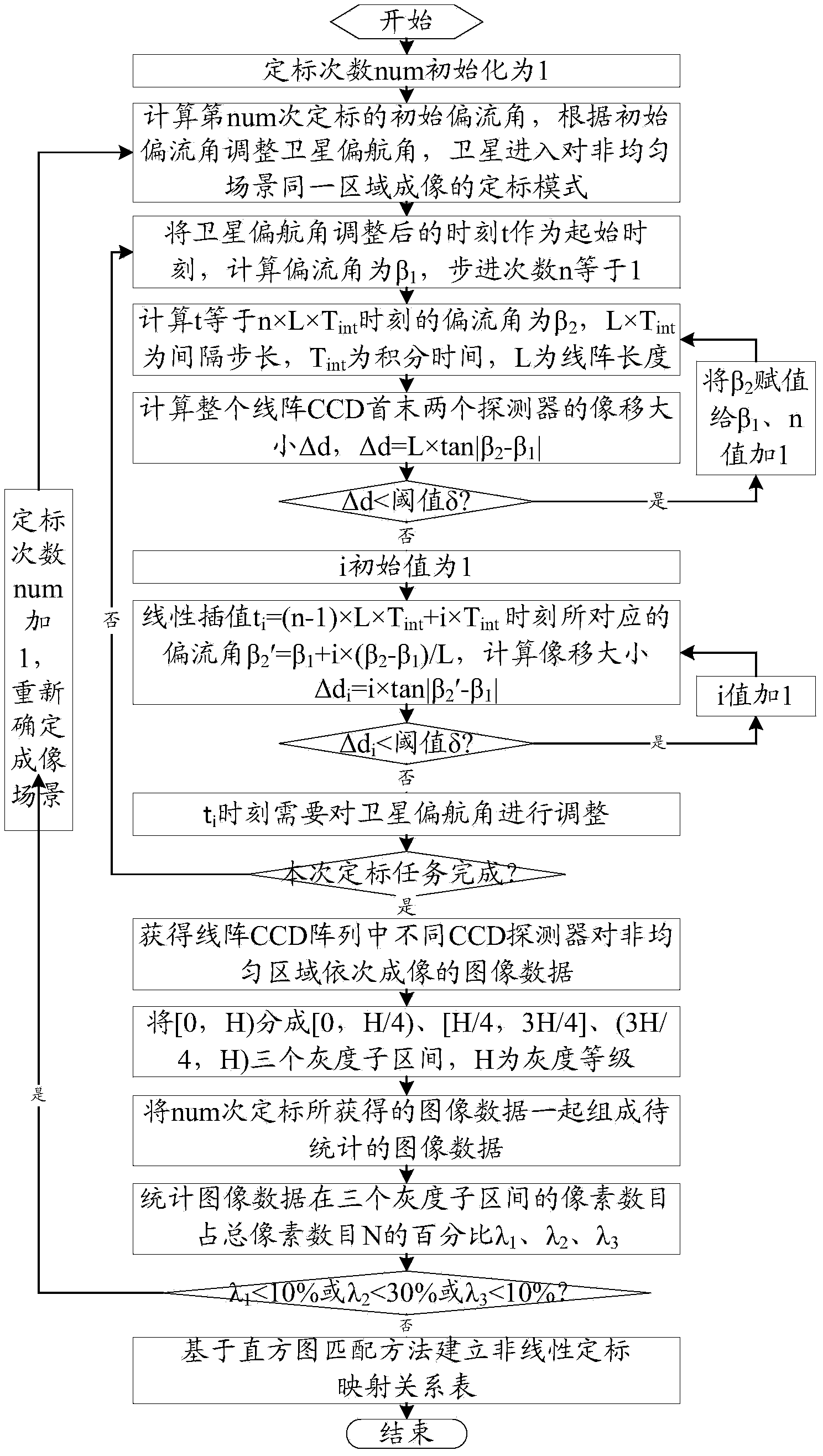
[0031] Attitude adjustment and nonlinear calibration method for imaging the same area of ​​a non-uniform scene, the specific steps are as follows figure 1 As shown, the method is implemented by the following steps:

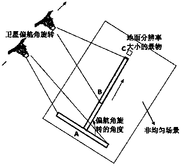
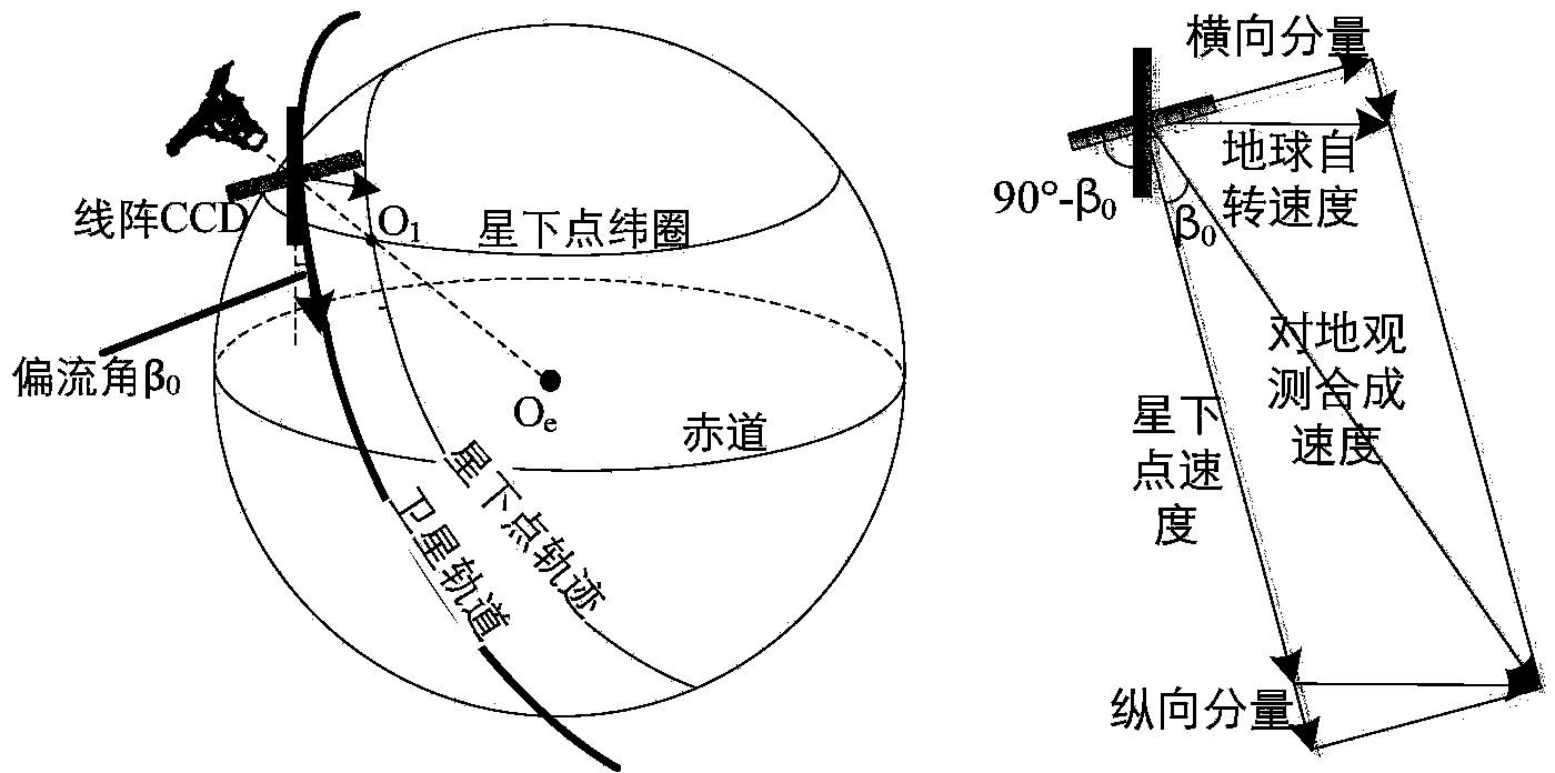
[0032] 1. When the satellite needs on-orbit calibration, calculate the initial drift angle β according to the image motion velocity 0 , and adjust the satellite yaw angle according to the initial yaw angle, the adjustment method is to rotate the satellite yaw angle counterclockwise by 90°-β 0 , enter the calibration mode for imaging the same area of ​​the non-uniform scene.

[0033] The calibration mode for imaging the same area of ​​a non-uniform scene is to arrange the direction of the linear array CCD array in a way that is similar to the direction of satellite movement, so that the linear array CCD array can sequentially image the same area of ​​​​a non-uniform scene, so that it can Obtain a large amount of data from imaging the same area of ​​a non-uniform ...


PUM


Abstract

The invention relates to an attitude adjustment and nonlinear calibration method for imaging in the identical region of a heterogeneous scene. The attitude adjustment and nonlinear calibration method comprises the following steps: calculating an initial drift angle of satellite imaging and adjusting a satellite yaw angle, transferring into a calibration mode of imaging in the same region of the heterogeneous scene; accurately calculating an image drift size by adopting a top-down time interface step length in an imaging process of the calibration mode, controlling an accurate push-sweeping direction of imaging of a linear array CCD (Charge Coupled Device) through adjusting the satellite yaw angle to ensure that the linear array CCD can be used for sequentially imaging the identical region; and determining whether the obtained image data meets the condition of nonlinear calibration, and if being met, establishing a nonlinear calibration mapping relationship table on the basis of histogram matching histogram matching, and if not, re-determining an imaging scene to continuously execute on-tract calibration so that more image data is obtained. The attitude adjustment and nonlinear calibration method is low in requirement for a ground scene without a more uniform scene; a non-uniform scene can meet a calibration task, each track of satellite operating can realize calibration, with high calibration frequency.

Description

technical field [0001] The invention relates to an attitude adjustment and non-linear calibration method for imaging the same area of ​​a non-uniform scene, belongs to the technical field of remote sensing satellite calibration, and is especially used for attitude adjustment and non-linear calibration of an optical remote sensing satellite linear array CCD camera for imaging the same area of ​​​​a non-uniform scene. Linear scaling. Background technique [0002] At present, the linear array CCD cameras of optical remote sensing satellites mainly use push-broom imaging to acquire satellite images. However, there are problems such as non-uniformity noise and dark current noise in each CCD detector and amplification gain of the remote sensing satellite camera, which leads to inconsistency in the response of the optical system and CCD detector, which is directly manifested in the inconsistency of the output gray value of each pixel , resulting in some "banding" or "streaks" in t...

Claims


Application Information

Patent Timeline
IPC IPC(8): G01C25/00G01C11/02
CPCG01C25/00
Inventor 李海超满益云陈亮
Owner CHINA ACADEMY OF SPACE TECHNOLOGY
Why Eureka
Try Eureka