Storied household graph management system based on generic tree apportionment model

A management system and model technology, applied in the field of model calculation, can solve the problems of ambiguous, variable and inaccurate block names, and achieve the effect of improving work efficiency, improving accuracy and reliability, and reducing manual intermediate links.

Active Publication Date: 2014-05-28
NANJING NORMAL UNIVERSITY
View PDF2 Cites 8 Cited by
  • Summary
  • Abstract
  • Description
  • Claims
  • Application Information

AI Technical Summary

Problems solved by technology

Location information plays an important role in the identification of houses. In traditional real estate management, the location of houses is generally defined by the name of the city block, and the block name is fuzzy, variable, and imprecise, and it is difficult to fundamentally eliminate it. Occurrence of repeated certificate issuance

Method used


Image

  • Storied household graph management system based on generic tree apportionment model
  • Storied household graph management system based on generic tree apportionment model
  • Storied household graph management system based on generic tree apportionment model

Examples


Embodiment

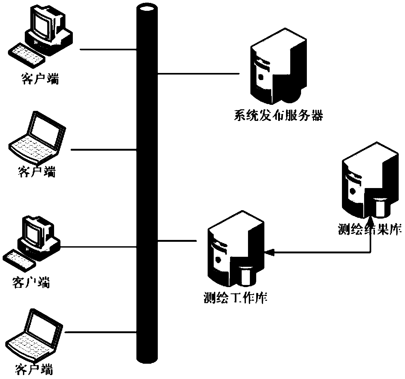
[0081] The hierarchical household map management system based on the pan-tree apportionment model is based on a distributed structure, and updates are released uniformly through the Clickonce publishing server, and the surveying and mapping data results are stored separately in the surveying and mapping work library and the surveying and mapping result library ( figure 1 ).

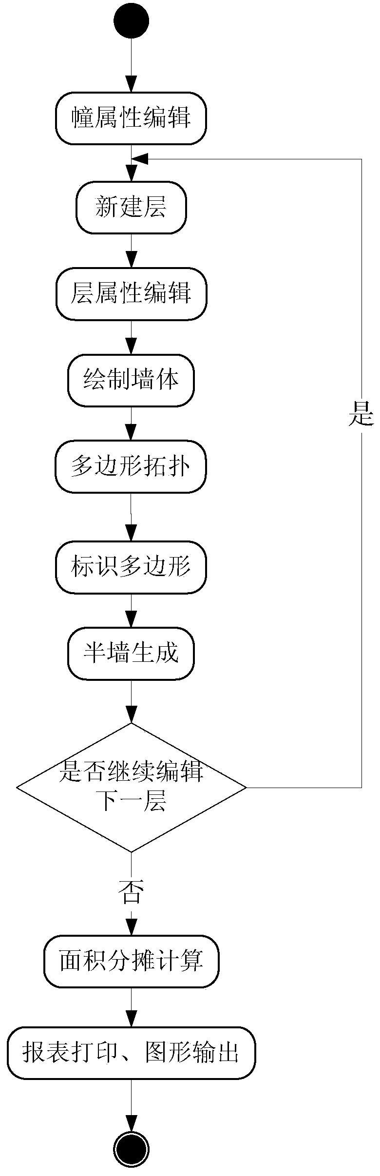
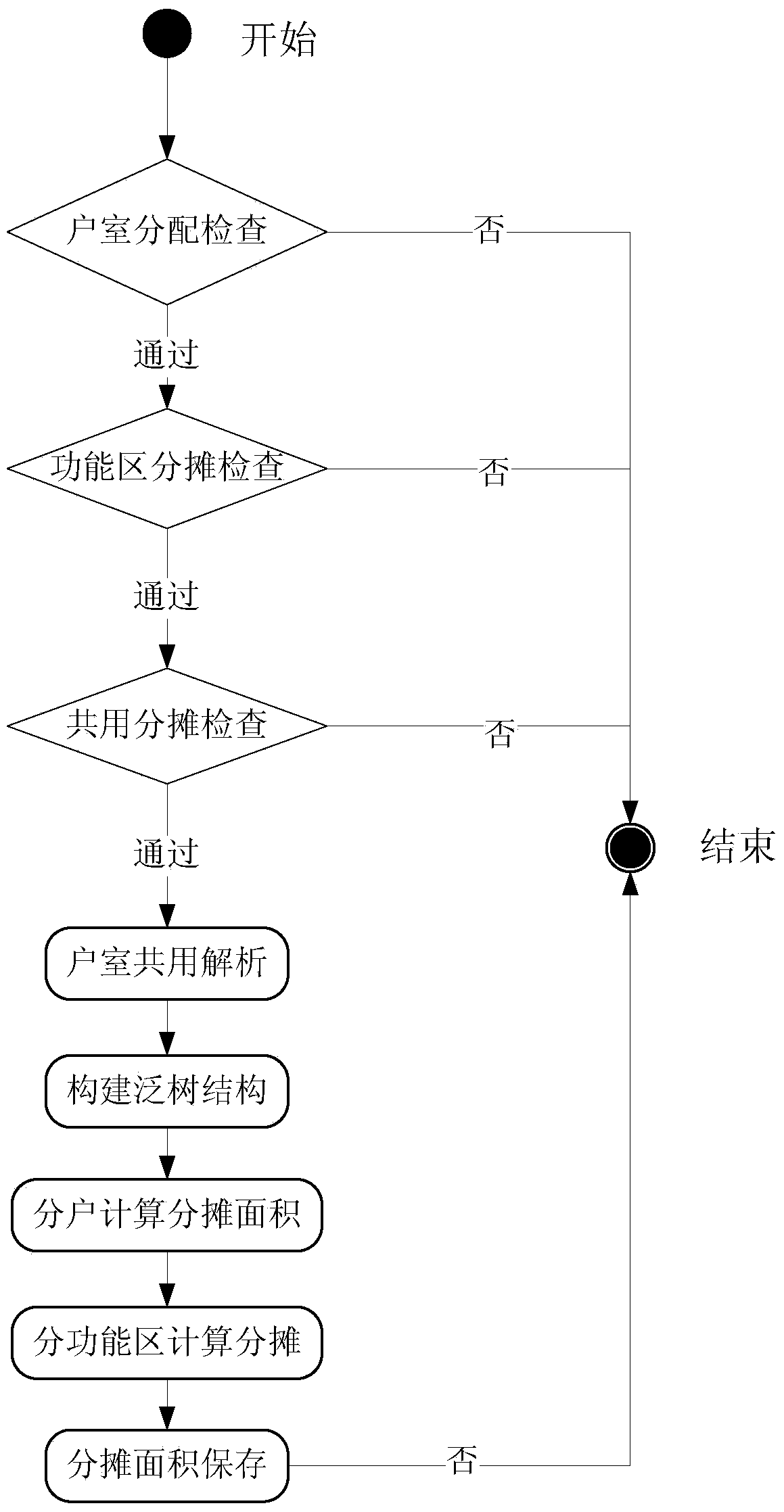
[0082] The system draws the walls of each floor through the graphic editing function, and flexibly defines the type of each room, and shares the floors, functional areas, buildings, etc. Multi-level and step-by-step allocation of area, extending the concept of functional areas, and flexibly defining algorithms to adapt to the needs of changes in area calculation and shared building area allocation rules. Finally, according to the real estate map schema of the real estate surveying and mapping standard, the standard layered map, household map, certificate distribution map, etc. are output ( figure 2 ). ...


PUM


Abstract

The invention discloses a storied household graph management system based on a generic tree apportionment model. The system comprises a house wall editing module, a room definition module, an area apportionment calculating module and a house graph making and printing module. The house wall editing module is used for drawing house walls, defining the width of the walls and establishing the topological relation between the walls. The room definition module is used for automatically working out a room graph of a house according to wall data formed by the house wall editing module and classifying rooms of the house according to functional zones where the rooms of the house belong. The area apportionment calculating module is used for performing apportionment calculation according to the functional zones where the rooms of the house belong and calculating apportioned area and apportioned zones of all households. The house graph making and printing module is used for making and printing graphs according to a measuring scale, printing house household area list and the like, wherein the graphs are formed according to user house graph data. The dynamic error correction technology is adopted in the system, shared area apportionment is performed according to the standard apportionment model, and the accuracy and the reliability of area calculation in house property surveying and mapping management are improved.

Description

technical field [0001] The invention belongs to the technical field of model calculation, and in particular relates to a house surveying and mapping layered household map management system for calculation through the pan-tree apportionment model, especially relates to the definition method of the apportionment model, the process of making the layered household map, and the apportionment method of the pan-tree model The housing surveying and mapping layered household map management system. Background technique [0002] In recent years, with the rapid development of the social economy and the promotion of relevant policies such as the reform of the urban housing system, the real estate market has been greatly developed, and housing transactions have become increasingly active, showing a development trend of both supply and demand. The work tasks of real estate management are becoming more and more heavy. Real estate management departments in various places actively promote the...

Claims


Application Information

Patent Timeline
Patent Type & Authority Applications(China)
IPC IPC(8): G06Q10/06G06Q50/16
Inventor 张宏乔延春闾国年蒋文明
Owner NANJING NORMAL UNIVERSITY
Why Eureka
Try Eureka