Remote Sensing Metadata Integration Method Based on Semantic Template

An integration method and metadata technology, applied in the field of data integration, can solve problems such as the inability to provide shared heterogeneous remote sensing data, and few methods for semantic heterogeneity, and achieve the effect of solving the integration of different types of remote sensing metadata

Active Publication Date: 2017-08-15
ZHEJIANG UNIV
View PDF1 Cites 0 Cited by
  • Summary
  • Abstract
  • Description
  • Claims
  • Application Information

AI Technical Summary

Problems solved by technology

This method solves the problem that the traditional remote sensing application centers are separated from each other and cannot provide shared heterogeneous remote sensing data
[0006] This kind of data integration method solves the syntactic heterogeneity and structural heterogeneity to a certain extent, but it has few solutions for semantic heterogeneity

Method used


Image

  • Remote Sensing Metadata Integration Method Based on Semantic Template
  • Remote Sensing Metadata Integration Method Based on Semantic Template
  • Remote Sensing Metadata Integration Method Based on Semantic Template

Examples


Embodiment Construction

[0044] The specific implementation of the present invention will be described below in conjunction with the accompanying drawings. It should be noted that the current embodiments are for illustration only, and are not intended to limit the present invention.

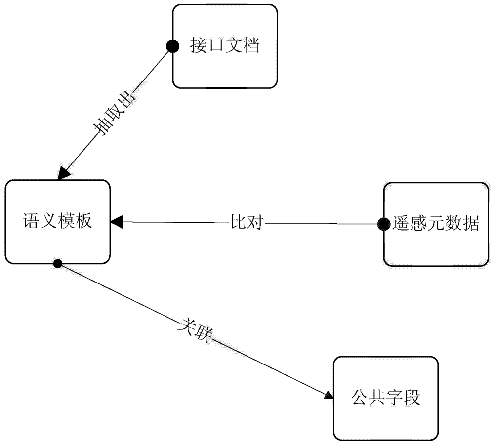
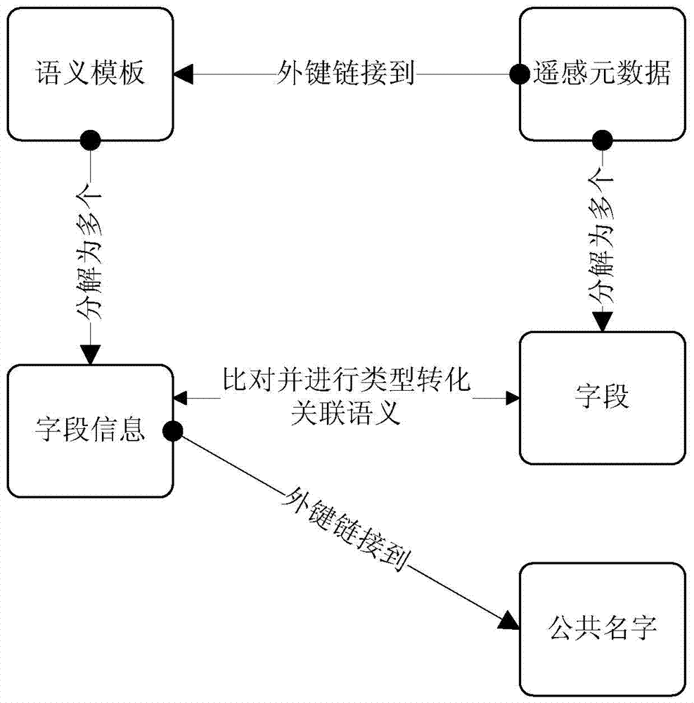
[0045] figure 1 It is a schematic diagram of the relationship between entities involved in an embodiment of the present invention, and the method of the present invention is described in detail according to this embodiment.

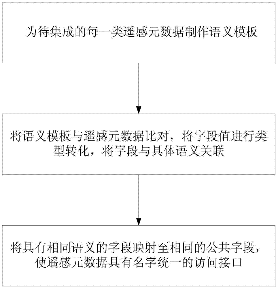
[0046] like image 3 Shown, the concrete steps of the inventive method are as follows:

[0047] Step 1: Create a corresponding semantic template for each type of remote sensing metadata to be integrated, and store the semantic template.

[0048] Among them, the semantic templates corresponding to the same type of remote sensing metadata have unified semantics, and the specific steps for making semantic templates are as follows:

[0049] Step 1-1, setting unified semantics, making an initial sema...


PUM


Abstract

The invention discloses a remote-sensing metadata integration method based on lexeme templates. The remote-sensing metadata integration method based on the lexeme templates comprises the steps that (1) a lexeme template corresponding to each category of remote-sensing metadata to be integrated is established, and the lexeme templates are stored; (2) the corresponding categories of remote-sensing metadata are analyzed and stored according to the lexeme templates, type conversion is conducted on field values of fields of the remote-sensing metadata, and fields obtained after conversion are made to be associated with specific lexemes; (3) the fields, having the same lexemes, in the different lexeme templates are mapped to the same common field, and thus access interfaces with the unified name for the remote-sensing metadata is available. According to the remote-sensing metadata integration method based on the lexeme templates, based on the characteristics of the remote-sensing metadata, integration of different categories of remote-sensing metadata can be achieved effectively according to lexemes.

Description

technical field [0001] The invention relates to the field of data integration, in particular to a semantic template-based remote sensing metadata integration method. Background technique [0002] With the increasing popularity of remote sensing data sharing, how to effectively realize the heterogeneous integration of different types of remote sensing data has become an important issue. [0003] Remote sensing data will evolve into various categories from collection to post-processing. Remote sensing metadata has become an important data form to describe remote sensing data. How to integrate remote sensing metadata from different units, different types, and heterogeneity into a library, and provide a unified access interface to the upper layer has become a key issue. [0004] Most remote sensing metadata exists in XML format, and there are differences among different types of remote sensing metadata, but there are also many semantic commonalities. The traditional heterogen...

Claims


Application Information

Patent Timeline
Patent Type & Authority Patents(China)
IPC IPC(8): G06F17/30
CPCG06F16/258
Inventor 陶金火刘娜欧阳宇彤郑国轴陈华钧吴朝晖
Owner ZHEJIANG UNIV
Why Eureka
Try Eureka