
Control method of accurate landing of unmanned aerial vehicle

A control method and UAV technology, applied in three-dimensional position/channel control and other directions, to make up for the lack of accuracy and improve the landing accuracy

Inactive Publication Date: 2014-07-30
UNIV OF SHANGHAI FOR SCI & TECH
View PDF3 Cites 33 Cited by
  • Summary
  • Abstract
  • Description
  • Claims
  • Application Information

AI Technical Summary

Problems solved by technology

But there are still many problems, one of the main problems is the precise landing of drones
UAVs use GPS for flight navigation. The accuracy of current civilian GPS positioning (such as China Beidou) can only reach within 10 meters. This accuracy is still too large for UAVs to accurately deliver express delivery.

Method used


Image

  • Control method of accurate landing of unmanned aerial vehicle
  • Control method of accurate landing of unmanned aerial vehicle
  • Control method of accurate landing of unmanned aerial vehicle

Examples


Embodiment Construction

[0024] The control method for the precise landing of the drone provided by the present invention will be described in detail below in conjunction with the accompanying drawings.

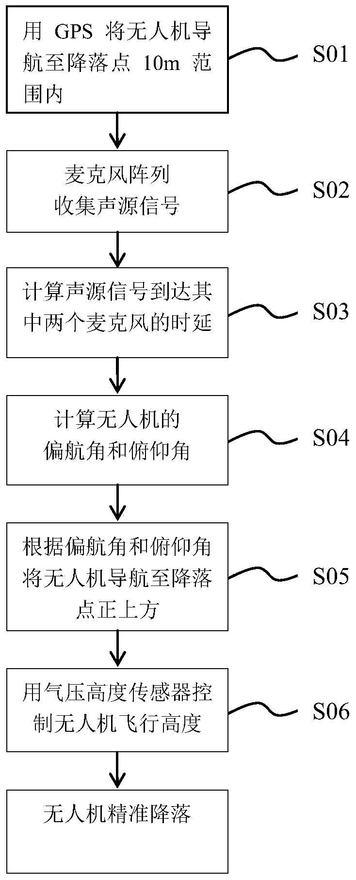
[0025] figure 1 It is a flow chart of the control method for precise landing of the drone in the embodiment.

[0026] Such as figure 1 As shown, the control method of the precise landing of the drone provided by the present invention comprises the following steps:

[0027] Step S01: Use GPS to navigate the UAV to the vicinity of the landing point. Due to the limitation of the accuracy of GPS navigation, the error of the UAV reaching the precise position of the landing point is -10m~10m.

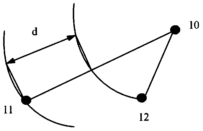
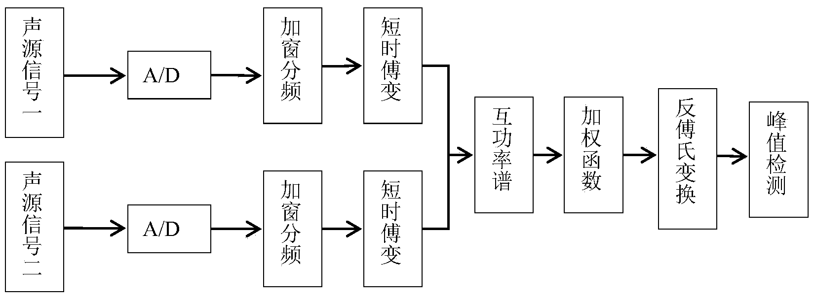
[0028] Step S02: Place a sound source at the landing point, and place a microphone array on the drone to collect the sound source signal. The microphone used in this embodiment is an omnidirectional electret microphone, consisting of four omnidirectional electret microphones. The microphones form a tetrahedral mi...


PUM


Abstract

The invention provides a control method of accurate landing of an unmanned aerial vehicle. The control method is used for controlling the unmanned aerial vehicle to reach a present landing point. The control method is characterized by comprising the following steps that 1 a sound source is placed at the landing point, regular-tetrahedron-shaped microphone arrays are placed on the unmanned aerial vehicle and a signal amplification circuit and a filtering circuit are arranged at the signal output end of each microphone; 2 GPS navigation is used for controlling the unmanned aerial vehicle to reach the range which is ten meters away from the landing point; 3 a processor on the unmanned aerial vehicle is used for calculating delay generated when sound source signals reach the second microphone, the third microphone, the fourth microphone and the first microphone; 4 the yaw angle and the pitch angle of the unmanned aerial vehicle are calculated through the processor according to the spatial geometric relationship of the sound source and the microphone arrays and delay values; 5 the unmanned aerial vehicle is navigated to the position over the landing point according to the yaw angle and the pitch angle; 6 an air pressure height sensor is used for enabling the unmanned aerial vehicle to be landed at the landing point accurately.

Description

technical field [0001] The invention relates to a control method for realizing precise landing of an unmanned aerial vehicle by utilizing sound source time delay and precise positioning of a barometric altitude sensor. Background technique [0002] Decades ago, drones were only used for battlefield surveillance, guidance and correction of artillery impact points, relay guidance of maritime tactical missiles, hostage rescue, etc. In the 1990s, with the advancement of new materials, micro-electro-mechanical (MEMS), micro-inertial navigation (MIMU) and flight control technologies, micro-miniature drones are small in size, light in weight, easy to operate, flexible and flexible. It has excellent performances such as low noise and good concealment, showing broad application prospects in military and civilian fields. In the civilian field, micro quadrotors can be used for various types of monitoring, monitoring, patrol, search and rescue, photography, surveying and mapping, inves...

Claims


Application Information

Patent Timeline
Patent Type & Authority Applications(China)
IPC IPC(8): G05D1/10
Inventor 夏云龙魏国亮刘青阳李辉
Owner UNIV OF SHANGHAI FOR SCI & TECH
Learn More