Spatial information cloud computing system and implementing method thereof

A technology of spatial information and implementation methods, applied in computing, instruments, electrical digital data processing, etc., can solve problems such as high operation and maintenance costs, poor scalability, and high prices, and achieve the effect of rapid deployment services

Active Publication Date: 2014-09-03
PEKING UNIV
View PDF6 Cites 11 Cited by
  • Summary
  • Abstract
  • Description
  • Claims
  • Application Information

AI Technical Summary

Problems solved by technology

[0004] In order to solve the above-mentioned problems in the prior art, the present invention provides a spatial information cloud computing system with elastic computing capability and its implementation method, the purpose of which is to provide geographic information system (GIS) developers with a spatial information system that supports elastic computing The cloud service development platform solves the problems of massive spatial data storage difficulties, high operation and maintenance costs, slow computing, poor scalability, and high prices that are difficult to solve with existing technologies, and reduces the need for developers to develop cloud GIS applications with powerful computing capabilities. The cost and difficulty of development

Method used


Image

  • Spatial information cloud computing system and implementing method thereof
  • Spatial information cloud computing system and implementing method thereof
  • Spatial information cloud computing system and implementing method thereof

Examples


Embodiment Construction

[0034] The present invention will be further described below in conjunction with the accompanying drawings and specific embodiments.
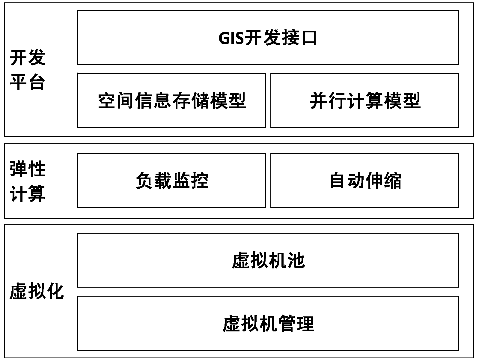
[0035] The basic idea of ​​the present invention is to use technologies such as virtualization and load monitoring to realize automatic elastic expansion of the system, and provide this capability to the development platform, so that all applications developed by using this platform have automatic elastic expansion.

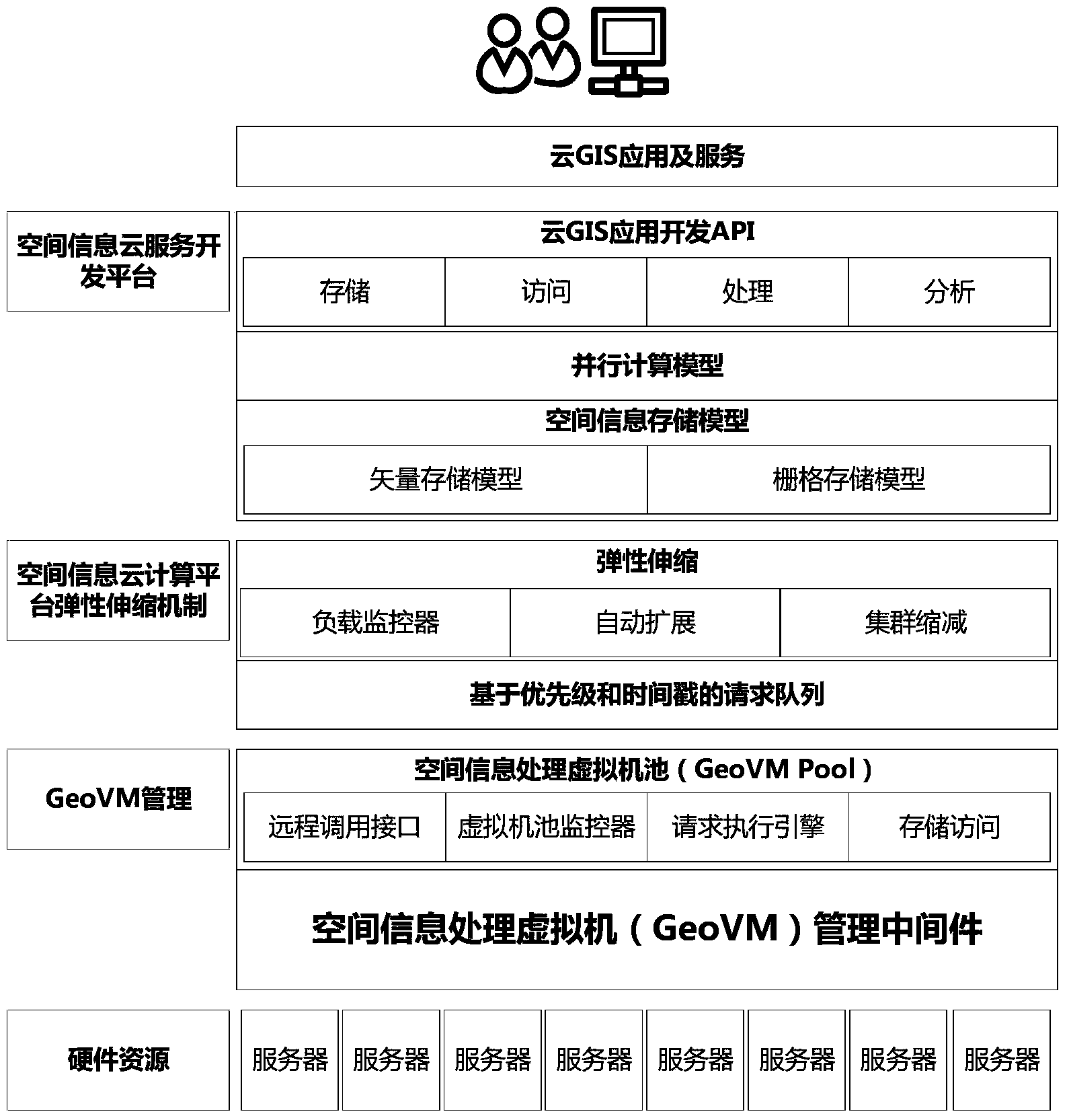
[0036] The structural block diagram of the spatial information cloud computing system of the present invention is as follows: figure 1 As shown, in this embodiment, the implementation method of the spatial information cloud computing system mainly includes creating a spatial information processing virtual machine (GeoVM), an elastic scaling mechanism of the spatial information cloud platform, and a spatial information cloud service development platform, specifically including the following steps:

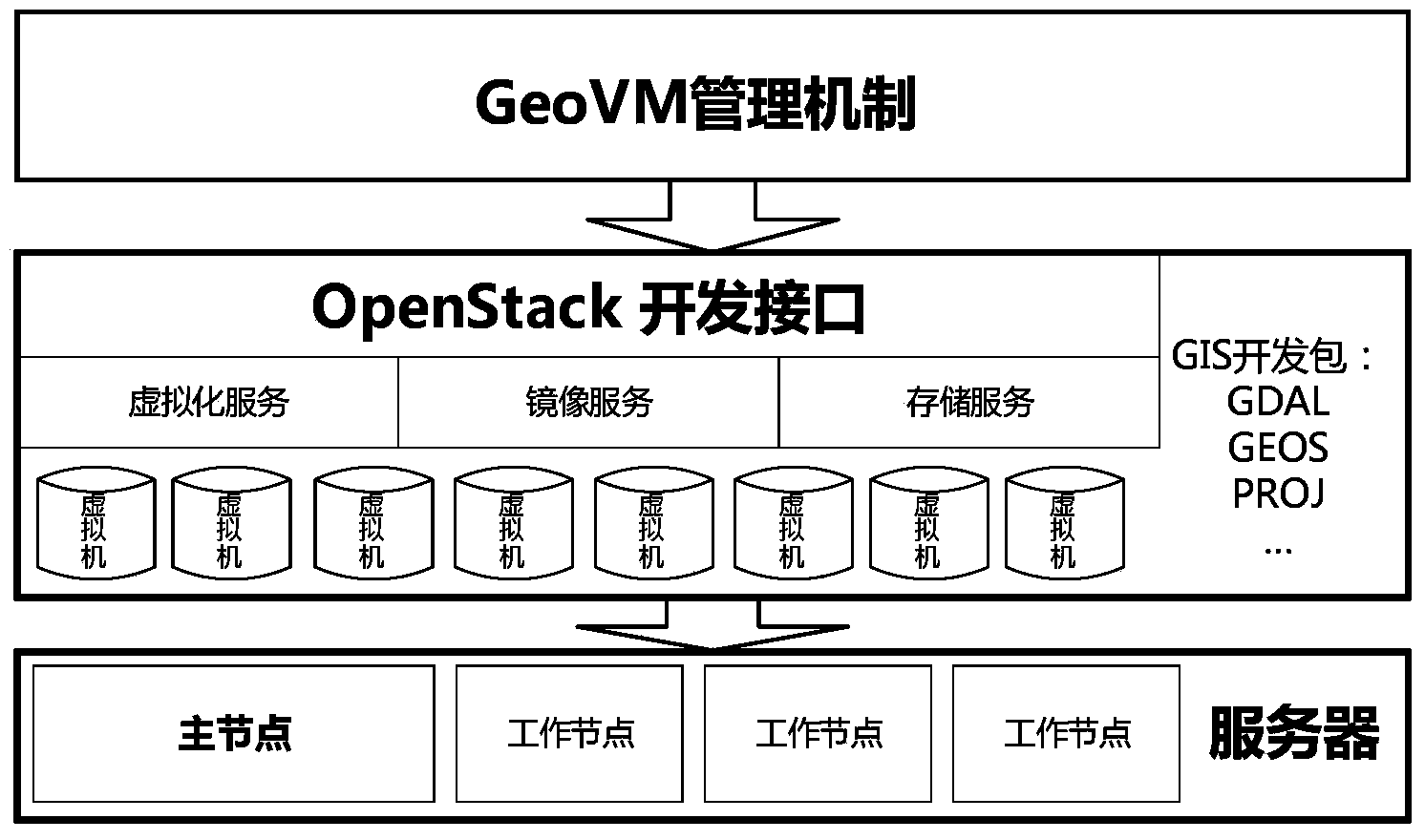
[0037] S1, by creating a spatial...


PUM


Abstract

The invention discloses a spatial information cloud computing system and an implementing method thereof. The system comprises a spatial information processing virtualization module, a spatial information elastic calculation module and a spatial information cloud service development platform module which provide a virtualization service for hardware sources, an automatic scalable service for calculation sources and a cloud GIS application development service to the external respectively. According to the system and the implementing method, a spatial information cloud service development platform supporting elastic calculation is provided for a GIS developer, the problems that massive spatial data are difficult to store, operating and maintaining cost is high, calculation speed is low, scalability is poor and the price is high are difficult to solve in the prior art but solved by the system and the implementing method, and therefore development cost and difficulty of the cloud GIS application with the strong calculation ability are reduced.

Description

technical field [0001] The invention relates to spatial information computing technology, in particular to a spatial information cloud computing system and its implementation method. Background technique [0002] Every advance in information technology will have a huge impact on geographic information system (GIS), such as PC to desktop GIS, Internet to WebGIS, grid computing to grid GIS, etc. The emergence of cloud computing provides an effective solution to solve the problems encountered in traditional GIS such as massive spatial data storage, high operation and maintenance costs, slow computing, poor scalability, and high prices. As a future-oriented geographic information system, cloud GIS has rapidly become the development trend and research hotspot of current GIS software. [0003] Geographic information software as a service (SaaS), geographic information platform as a service (PaaS) and geographic information infrastructure as a service (IaaS) are the three main ser...

Claims


Application Information

Patent Timeline
Patent Type & Authority Applications(China)
IPC IPC(8): G06F9/455G06F17/30
Inventor 陈斌刘跃虎
Owner PEKING UNIV
Why Eureka
Try Eureka