
Super-resolution wide-area imaging method for airborne battlefield monitoring radar of unmanned aerial vehicle

A technology for surveillance radar, imaging methods, applied in radio wave measurement systems, radio wave reflection/re-radiation, special data processing applications, etc. Technical imaging resolution and other issues

Inactive Publication Date: 2014-10-01
XIDIAN UNIV
View PDF6 Cites 2 Cited by
  • Summary
  • Abstract
  • Description
  • Claims
  • Application Information

AI Technical Summary

Problems solved by technology

However, due to the high revisit rate of data required by the wide-area GMTI and its wide-area surveillance capability for the scene, the irradiation time of the radar antenna for a certain azimuth angle is very short when scanning, so the coherent accumulation Time is very limited, which greatly limits the imaging resolution of Doppler beam sharpening technology

Method used


Image

  • Super-resolution wide-area imaging method for airborne battlefield monitoring radar of unmanned aerial vehicle
  • Super-resolution wide-area imaging method for airborne battlefield monitoring radar of unmanned aerial vehicle
  • Super-resolution wide-area imaging method for airborne battlefield monitoring radar of unmanned aerial vehicle

Examples


Embodiment Construction

[0057] The present invention will be further described below in conjunction with accompanying drawing:

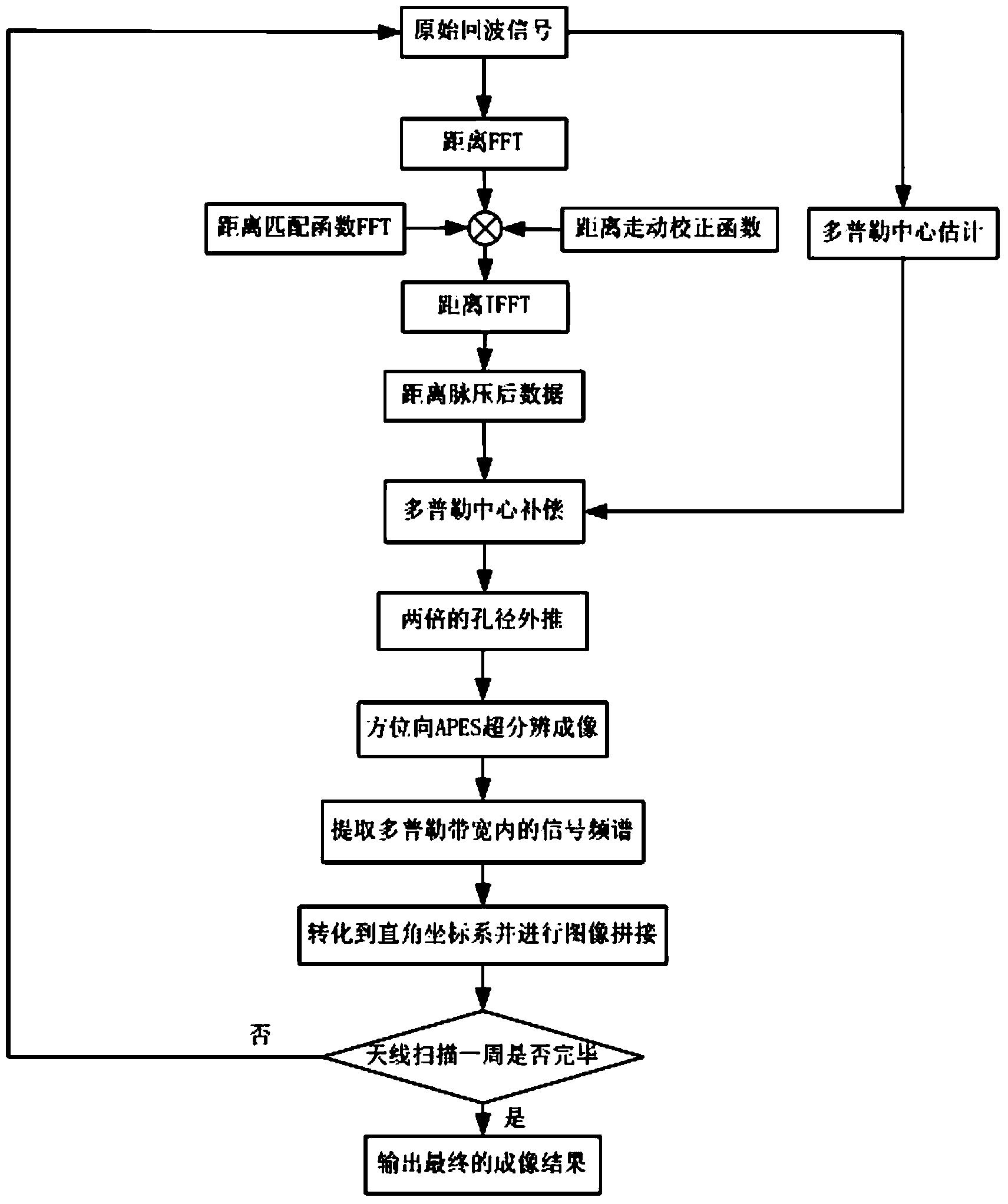
[0058] refer to figure 1 , is a flow chart of the super-resolution wide-area imaging method of the UAV-borne battlefield surveillance radar of the present invention. The UAV-borne battlefield surveillance radar super-resolution wide-area imaging method includes the following steps: when the UAV is flying, the irradiation area of ​​the battlefield surveillance radar on the UAV changes continuously; for each irradiation area of ​​the battlefield surveillance radar , generate the ground surveillance image of the corresponding irradiation area of ​​the battlefield surveillance radar, and combine the ground surveillance image of each irradiation area of ​​the battlefield surveillance radar into a wide-area ground surveillance image; generate the ground surveillance image of each irradiation area of ​​the battlefield surveillance radar including the following step:

[0059] Ste...


PUM


Abstract

The invention belongs to the technical field of super-resolution wide-area imaging for radars and in particular relates to a super-resolution wide-area imaging method for an airborne battlefield monitoring radar for an unmanned aerial vehicle. The super-resolution wide-area imaging method for the airborne battlefield monitoring radar for the unmanned aerial vehicle comprises the following step of combining ground monitoring images of all irradiation areas of the battlefield monitoring radar into a wide-area ground monitoring image. Generating the ground monitoring images of the irradiation areas of the battlefield monitoring radar comprises the following steps of preprocessing corresponding original echo data through the battlefield monitoring radar to obtain corresponding central post-compensation data, carrying out aperture extrapolation on the corresponding central post-compensation data in the azimuth to obtain corresponding aperture post-extrapolation data, carrying out amplitude phase estimation method super-resolution processing on the corresponding aperture post-extrapolation data in the azimuth to obtain corresponding azimuth super-resolution processed data and obtaining corresponding sub images according to the corresponding azimuth super-resolution processed data.

Description

technical field [0001] The invention belongs to the technical field of radar super-resolution wide-area imaging, and in particular relates to a super-resolution wide-area imaging method for UAV-borne battlefield surveillance radar, which can be used for fast wide-area imaging and monitoring of real-time ground scenes. Background technique [0002] Synthetic Aperture Radar (SAR) obtains high azimuth resolution by observing the ground scene for a long time. However, because this system does not have the ability to quickly revisit data, it cannot monitor long-distance and large-scale ground scene information. In contrast, Wide-area GMTI (Wide-area Ground Moving Target Indication), which uses narrower antenna beams and azimuth scanning, can achieve rapid imaging of large ground scenes. Due to its high interview rate, it can repeatedly detect wide-area scenes (200km×200km), becoming the most important working method for battlefield surveillance. For example, JSTARS (Joint Surve...

Claims


Application Information

Patent Timeline
Patent Type & Authority Applications(China)
IPC IPC(8): G01S13/90G06F19/00
CPCG01S7/40G01S13/90
Inventor 李明陈洪猛刘鹏王帅吴艳卢云龙贾璐张鹏
Owner XIDIAN UNIV
Learn More