Large-area complex-terrain-region unmanned plane sequence image rapid seamless splicing method

A seamless splicing and large-area technology, applied in the field of image processing, can solve the problem of high positioning accuracy

Inactive Publication Date: 2014-11-19
SHANDONG LINYI TOBACCO
View PDF2 Cites 27 Cited by
  • Summary
  • Abstract
  • Description
  • Claims
  • Application Information

AI Technical Summary

Problems solved by technology

[0004] Aiming at the deficiencies of the prior art, the present invention provides a method for fast and seamless splicing of UAV sequence images in large areas with complex terrains

Method used


Image

  • Large-area complex-terrain-region unmanned plane sequence image rapid seamless splicing method
  • Large-area complex-terrain-region unmanned plane sequence image rapid seamless splicing method
  • Large-area complex-terrain-region unmanned plane sequence image rapid seamless splicing method

Examples


Embodiment Construction

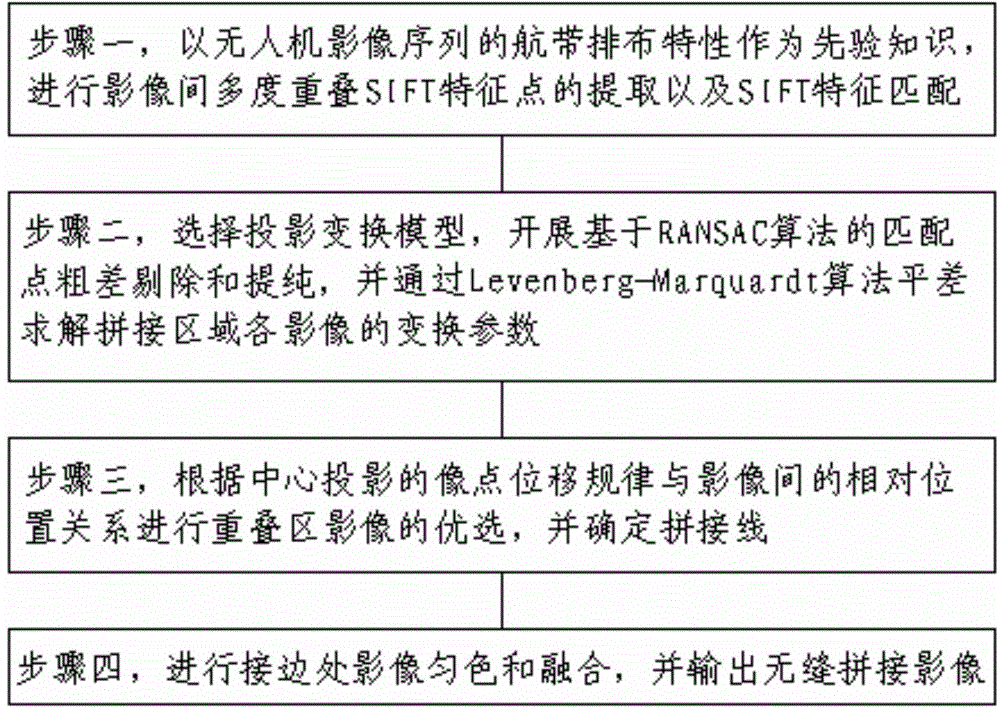
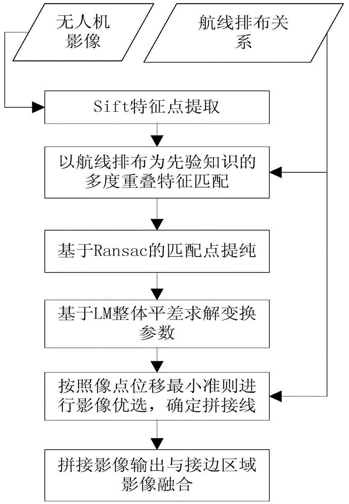
[0044] In order to clearly illustrate the technical features of this solution, the present invention will be described in detail below through specific implementation modes and in conjunction with the accompanying drawings. The following disclosure provides many different embodiments or examples for implementing different structures of the present invention. To simplify the disclosure of the present invention, components and arrangements of specific examples are described below. Furthermore, the present invention may repeat reference numerals and / or letters in different instances. This repetition is for the purpose of simplicity and clarity and does not in itself indicate a relationship between the various embodiments and / or arrangements discussed. It should be noted that components illustrated in the figures are not necessarily drawn to scale. Descriptions of well-known components and processing techniques and processes are omitted herein to avoid unnecessarily limiting the...


PUM


Abstract

Provided is a large-area complex-terrain-region unmanned plane sequence image rapid seamless splicing method which comprises the following steps: to begin with, with air strip arrangement features of unmanned plane image sequence being prior knowledge, carrying out inter-image multiple-overlap SIFT feature point extraction and matching; then, carrying out matching point gross error removing and purifying based on random sample consensus algorithm, and solving transformation parameters of each image in spliced regions in an adjustment manner through an Levenberg-Marquardt algorithm; next, carrying out overlapped region image optimized selection according to the relative position relationship between central projection image point displacement rules and the images, and determining splicing lines; and finally, carrying out image uniform-coloring and fusion at the edge-connection places, and outputting spliced images, thereby realizing mass unmanned plane image seamless splicing. The seamless splicing method helps to improve the extraction efficiency of the SIFT feature points, guarantee the geometric accuracy of the spliced images, and eliminate the tiny color difference at the two sides of the image splicing line, and thus the spliced images with natural color transition and good natural object and landform continuity are obtained.

Description

technical field [0001] The invention relates to a UAV remote sensing image processing method, in particular to a method for fast and seamless splicing of UAV sequence images in a large area with complex terrain, and belongs to the technical field of image processing. Background technique [0002] UAV remote sensing is a new type of remote sensing system that has emerged in recent years. Due to its characteristics of fast, flexible, low cost, and high image resolution, it is increasingly becoming an important means of spatial data acquisition. It is used in crop monitoring, land resource monitoring , Disaster emergency response, disaster assessment, battlefield reconnaissance, fire monitoring and other fields play an important role. Due to the broad application prospects of UAV remote sensing, the corresponding image processing technology has also received extensive attention and attention. UAV sequence image stitching in large-scale complex terrain areas (mountains, hills) i...

Claims


Application Information

Patent Timeline
IPC IPC(8): G06T7/00
Inventor 董梅苏建东刘广玉杨举田林祥国孙晓峰程云吉王梅勋张彦东宗浩田雷刘勇徐硕武博谭效磊朱先志刘莉王苜华王丽丽
Owner SHANDONG LINYI TOBACCO
Why Eureka
Try Eureka