Modeling method for three-dimensional terrain

A three-dimensional terrain and modeling method technology, applied in the field of GIS, can solve the problems of single terrain model structure and effect, poor real-time rendering of three-dimensional terrain, single terrain conversion algorithm, etc. realistic effect

Inactive Publication Date: 2014-11-19
UNIV OF ELECTRONIC SCI & TECH OF CHINA
View PDF1 Cites 12 Cited by
  • Summary
  • Abstract
  • Description
  • Claims
  • Application Information

AI Technical Summary

Problems solved by technology

So as to solve the problems of complex texture production, single terrain transformation alg

Method used


Image

  • Modeling method for three-dimensional terrain

Examples


Embodiment Construction

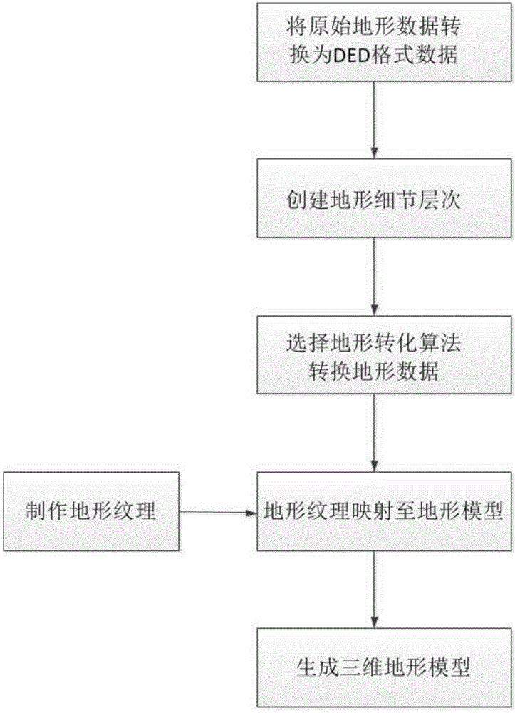
[0027] The technical invention of the present invention will be described in detail below in conjunction with the embodiments and accompanying drawings.

[0028] The radar scene simulation in this embodiment is an application scenario, and the three-dimensional terrain modeling described in the present invention is adopted in view of the large area to be simulated in the radar scene simulation, the real-time change of the simulated scene, and the perfection of details. method to build a view. Finally, the realistic construction of the terrain model in the scene is realized, which ensures the highly realistic and real-time rendering of the model in the radar scene simulation.

[0029] During radar visual simulation, because the irradiation area of ​​the radar is wide, the visual scene is usually hundreds of square kilometers, resulting in a very large area of ​​three-dimensional terrain to be simulated, which makes terrain modeling more difficult. In the three-dimensional terra...


PUM


Abstract

The invention belongs to the technical field of GISs (Geographic Information System), and particularly relates to a method for constructing a three-dimensional terrain model by using data and satellite pictures of a digital elevation model (DEM). The method comprises the following steps: using the data of an original terrain to generate a model, using a map satellite photo as a grain, and using four kinds of algorithms such as a polymesh, a delaunay, a terrain culture triangulation (TCT) and continuous adaptive terrain (CAT) to transform and generate the three-dimensional terrain model, so that the problems of single structure and effect of the terrain model and poor real-time rendering performance of the three-dimensional terrain due to a complicated grain manufacture method and the single terrain transforming algorithm are solved.

Description

technical field [0001] The invention belongs to the technical field of GIS, in particular to a method for constructing a three-dimensional terrain model by using digital elevation model (Digital Elevation Model, DEM) data and satellite images. Background technique [0002] A Geographic Information System (GIS) can map and analyze what exists and what happens on Earth. 3D terrain modeling technology is often used in GIS to visualize and simulate terrain. Three-dimensional terrain modeling is to create a surface model that describes a certain part of the earth's surface and its characteristics. At present, the three-dimensional terrain modeling process mainly includes: using data to determine the surface model, using texture mapping to map image data to the terrain model to achieve terrain realism, and using methods such as level of detail to achieve real-time terrain rendering. [0003] Existing inventions such as the patent with the application number 200910244296.0 and th...

Claims


Application Information

Patent Timeline
IPC IPC(8): G06T17/05
Inventor 沈晓峰邢川杜龙飞殷文昭王军强徐敦毅
Owner UNIV OF ELECTRONIC SCI & TECH OF CHINA
Why Eureka
Try Eureka