Construction method of dual-mode three-dimensional terrain stereo environment

A technology of three-dimensional terrain and construction methods, applied in 3D modeling, image data processing, instruments, etc., can solve problems such as low conversion accuracy, inability to achieve seamless roaming in a large range, and achieve flexible interaction, information acquisition and expression. Diverse, realistic effects

Active Publication Date: 2013-02-13
THE PLA INFORMATION ENG UNIV
View PDF1 Cites 16 Cited by
  • Summary
  • Abstract
  • Description
  • Claims
  • Application Information

AI Technical Summary

Problems solved by technology

[0005] The purpose of the present invention is to provide a dual-mode three-dimensional terrain environment construction method to solve the problem of low conversion accuracy and inability to realize large-scale seamless roaming due to the use of a single mode in the current three-dimensional terrain environment construction process. question

Method used


Image

  • Construction method of dual-mode three-dimensional terrain stereo environment
  • Construction method of dual-mode three-dimensional terrain stereo environment
  • Construction method of dual-mode three-dimensional terrain stereo environment

Examples


Embodiment Construction

[0032] The specific embodiments of the present invention will be further described below in conjunction with the accompanying drawings.

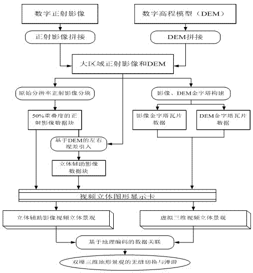
[0033] The construction process of the dual-mode terrain 3D terrain environment is as follows: figure 1 As shown, the core processing steps of the entire construction process include: orthophoto with 50% overlap and DEM block; DEM-based stereo auxiliary image generation; dual-mode 3D data association based on geocoding. Each step of its specific implementation approach is introduced below.

[0034] 1. Seamlessly splicing framed orthophoto images and DEM generated from aerial photos or satellite photos.

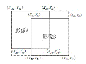
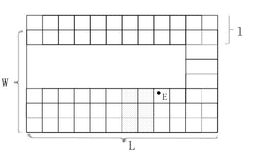
[0035] In order to process the orthophoto and DEM data of a large area in blocks and layers according to certain rules, so as to realize seamless stereoscopic observation and roaming in a large area, it is necessary to seamlessly splicing the orthophoto and DEM, and the stitching of orthophoto Including geometric stitching and radiation st...


PUM


Abstract

The invention relates to a construction method of a dual-mode three-dimensional terrain stereo environment, belonging to the field of the electronic technology of computer graphics. The method generates a stereo auxiliary image stereo landscape based on an orthographic stereopair and a dual-mode three-dimensional stereo environment organically combining virtual three-dimensional geographical landscapes based on DEM (digital elevation model) and orthoimage through a unified data organization mode by use of the basic data such as orthoimage, stereo auxiliary image, DEM and the like, and realizes the linkage roaming, seamless switching and information interconnection of two three-dimensional environments under the drive of data scheduling and landscape roaming engines; and a user can perform basic information inquiry and space analysis operation in the two landscapes. Through the invention, the constructed dual-mode three-dimensional terrain environment has the characteristics of flexible interaction, vivid effect, strong immersion, high measurement precision, diverse information acquisition and expression modes and the like.

Description

technical field [0001] The invention relates to a method for constructing a dual-mode three-dimensional terrain environment, and belongs to the technical field of computer graphics and electronics. Background technique [0002] In the field of computer graphics, using computer image graphics technology, the three-dimensional space information is projected and transformed to a two-dimensional computer screen, and a real-time rendering image with a high degree of reality is obtained, which is called a computer three-dimensional landscape. The traditional three-dimensional landscape construction method of computer terrain is based on digital elevation model (DEM) and digital ortho-sensing image (DOM), using calculation-based graphics algorithms such as three-dimensional perspective transformation, and superimposing the two on the computer screen. This 3D landscape is characterized by flexible interaction, realistic effects, and strong sense of immersion. However, due to the inf...

Claims


Application Information

Patent Timeline
Patent Type & Authority Applications(China)
IPC IPC(8): G06T17/05
Inventor 周杨徐青王新义李新涛戴晨光滕飞靳国旺蓝朝桢邢帅何钰
Owner THE PLA INFORMATION ENG UNIV
Why Eureka
Try Eureka