Near-space missile-borne strap-down inertial navigation system transfer alignment method based on star sensor

A technology of star sensor and transfer alignment, applied in the direction of instruments, measuring devices, etc., can solve the problems of lack of comprehensive consideration and low accuracy

Active Publication Date: 2014-11-26
SOUTHEAST UNIV
View PDF4 Cites 42 Cited by
  • Summary
  • Abstract
  • Description
  • Claims
  • Application Information

AI Technical Summary

Problems solved by technology

[0006] Purpose of the invention: The purpose of the present invention is to solve the problem of low precision caused by the lack of comprehensive consideration of the carrier kinematics and starlight measurement reference system in the prior art. The present invention is based on the star sensor-based transfer alignment method of the near-space missile-borne strapdown inertial navigation system , using the launch point inertial coordinate system as the navigation coordinate system, directly using the altitude and azimuth angle information output by the star sensor; establishing the state equation and measurement equation for any misalignment angle; comprehensively considering the installation error of the system, the lever arm and Deflection, establishes a more comprehensive transfer alignment; uses the sparse grid integration filter to correct and estimate the navigation parameters of the sub-inertial navigation system and the error of the inertial device

Method used


Image

  • Near-space missile-borne strap-down inertial navigation system transfer alignment method based on star sensor
  • Near-space missile-borne strap-down inertial navigation system transfer alignment method based on star sensor
  • Near-space missile-borne strap-down inertial navigation system transfer alignment method based on star sensor

Examples


Embodiment Construction

[0128] The technical solutions of the present invention will be described in detail below, but the protection scope of the present invention is not limited to the embodiments.

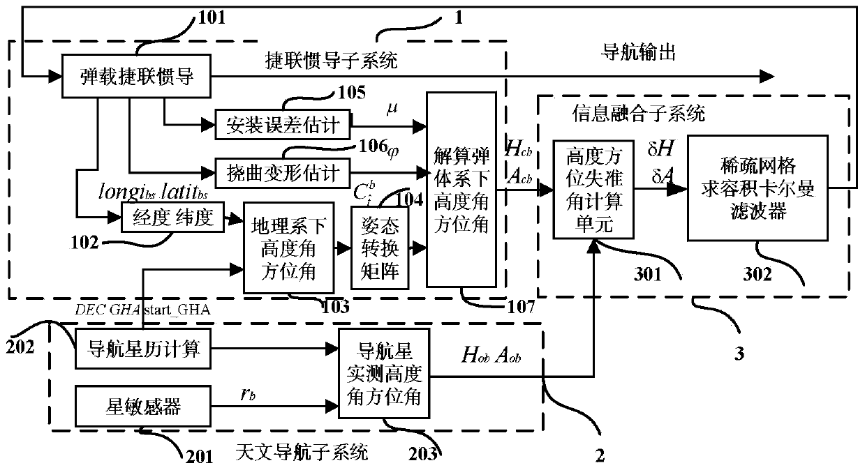
[0129] Such as figure 1 as shown, figure 1 Middle: 1—strapdown inertial navigation subsystem 2—celestial navigation subsystem 3—information fusion subsystem

[0130] 101—The strapdown inertial navigation unit is the missile-borne strapdown inertial measurement unit and the SINS calculation unit 102—The position information calculated by the missile-borne strapdown sub-inertial navigation is longitude and latitude

[0131] 103—Calculation of Altitude Angle and Azimuth Angle in Geographical Coordinate System

[0132] 104—Calculate the attitude transformation matrix from the geographic coordinate system to the projectile coordinate system

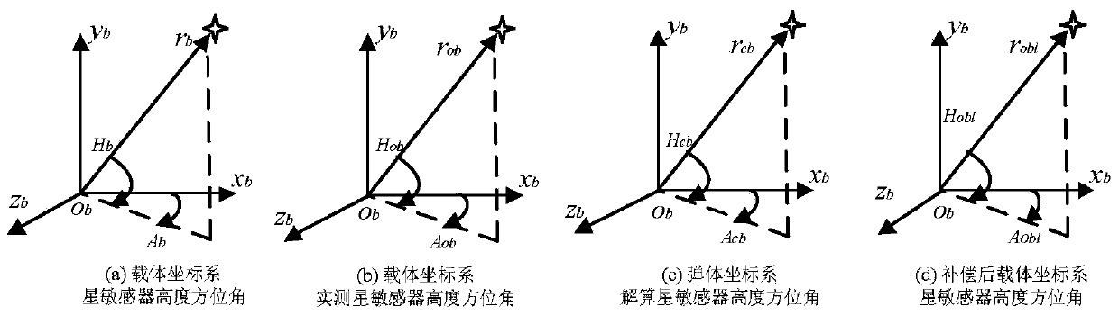
[0133] 105—Estimation of installation error between star sensor coordinate system or aircraft coordinate system and missile coordinate system

[0134] 106—Estimati...


PUM


Abstract

The invention discloses a near-space missile-borne strap-down inertial navigation system transfer alignment method based on a star sensor. The method comprises the following steps: 1) establishing a missile-borne strap-down inertial navigation system transfer alignment state equation by taking an inertial coordinate system (launching point coordinate system for short) on a carrier launching point as a navigation coordinate system and a strap-down inertial navigation system (SINS) on a missile to be launched as sub-inertial navigation; 2) calculating navigation information and observed quantity of the missile-borne strap-down inertial navigation system; 3) establishing a measurement equation; 4) by depending on the state equation and the measurement equation established, estimating a mathematics platform misalignment angle, a speed error, a position error and an installation error of the missile as well as flexural deflection of the carrier through a sparse grid integral kalman filter, and correcting a sub-inertial navigation system, thus finishing a transfer alignment process.

Description

technical field [0001] The invention relates to the technical field of integrated navigation transfer alignment, in particular to a method for transfer alignment of a near-space missile-borne strapdown inertial navigation system based on a star sensor. Background technique [0002] Near-space carrier is a new commanding height in the field of aerospace technology in the 21st century. Strapdown inertial navigation system is the main navigation equipment near the space carrier. It is a completely autonomous navigation technology. It has the advantages of high short-term accuracy, continuous output, strong anti-interference ability, and comprehensive navigation information. Accumulated, the sub-inertial navigation system of the missile near the space carrier needs to use the output information of the main inertial navigation or other auxiliary equipment (such as star sensors) to carry out alignment in order to achieve autonomous, fast and high-precision startup. Purpose. The ...

Claims


Application Information

Patent Timeline
Patent Type & Authority Applications(China)
IPC IPC(8): G01C25/00
CPCG01C25/005
Inventor 程向红陈红梅戴晨曦韩旭王晓飞
Owner SOUTHEAST UNIV
Why Eureka
Try Eureka