
Ocean wireless sensor network positioning method

A wireless sensor and network positioning technology, applied in satellite radio beacon positioning systems, positioning, radio wave measurement systems, etc., can solve problems such as uncertainty, influence, and difficulty in accurate deployment of anchor nodes, and achieve high positioning efficiency and cost. low effect

Active Publication Date: 2014-11-26
GUANGZHOU HKUST FOK YING TUNG RES INST
View PDF3 Cites 12 Cited by
  • Summary
  • Abstract
  • Description
  • Claims
  • Application Information

AI Technical Summary

Problems solved by technology

However, for the underwater environment, especially for the deep sea environment, it is very difficult to accurately deploy the anchor node on the seabed
This uncertainty in the location of anchor nodes has an impact on localization algorithms that rely on underwater anchor nodes
For another example, when the nodes are deployed on the sea, it is generally necessary to deploy the nodes on the buoys, so these nodes will fluctuate randomly with the wave fluctuations, and these random fluctuations make those methods suitable for locating land nodes ineffective. Applied at sea

Method used


Image

  • Ocean wireless sensor network positioning method
  • Ocean wireless sensor network positioning method
  • Ocean wireless sensor network positioning method

Examples


Embodiment Construction

[0029] The following will clearly and completely describe the technical solutions in the embodiments of the present invention with reference to the accompanying drawings in the embodiments of the present invention. Obviously, the described embodiments are only some, not all, embodiments of the present invention. Based on the embodiments of the present invention, all other embodiments obtained by persons of ordinary skill in the art without creative efforts fall within the protection scope of the present invention.

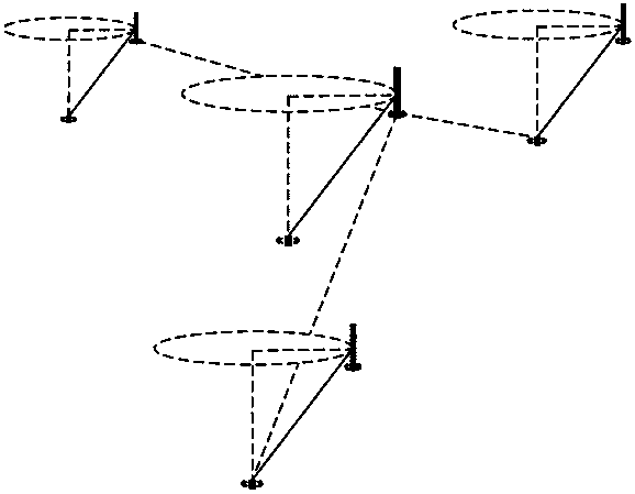
[0030] figure 1 It is a schematic flow chart of the first embodiment of a marine wireless sensor network positioning method provided by the present invention, as shown in figure 1 As shown, the method includes the steps of:

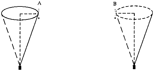
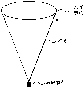
[0031] S11. Deploy several node combinations in the ocean, wherein each node combination includes a surface node floating on the water surface and a submarine node connected to the surface node and fixed on the seabed, and some surface nodes ...


PUM


Abstract

The invention provides an ocean wireless sensor network positioning method. The method includes the steps that multiple node combinations are deployed in the ocean, each node combination comprises a water surface node and an ocean floor node, wherein the water surface nodes float on the water surface, the ocean floor nodes are connected with the water surface nodes, deployed and fixed to the ocean floor, and the partial water surface nodes are provided with GPS positioning devices; the water surface nodes provided with the GPS positioning devices obtain position information at different time and send the position information to the ocean nodes connected with the water surface nodes; the positions of the ocean floor nodes are obtained through calculation based on the geometric principle according to the received position information of the water surface nodes at different time, and the ocean floor nodes connected with the water surface nodes provided with the GPS positioning devices are positioned. The algorithm cost is low, and positioning efficiency is high.

Description

technical field [0001] The invention relates to marine wireless sensor technology, in particular to a positioning method for marine wireless sensor networks. Background technique [0002] A wireless sensor network (Wireless Sensor Networks, WSN) is an Ad- hoc network, because this kind of network has strong adaptability, easy deployment, easy management, and the ability to monitor the deployed environment at a small scale and close range, it can obtain the monitoring information we need, and can be applied to military affairs, environmental monitoring and protection, and object tracking , health care, community security, intelligent transportation, smart city and other fields, so it has developed rapidly. [0003] With the development of wireless sensor networks, wireless sensor networks can be deployed in complex and variable ocean environments to realize real-time monitoring of the ocean. The marine wireless sensor network generally includes the network part deployed on ...

Claims


Application Information

Patent Timeline
Patent Type & Authority Applications(China)
IPC IPC(8): G01S5/18G01S19/42
CPCG01S5/0027G01S5/18G01S19/48
Inventor 罗汉江伍楷舜倪明选
Owner GUANGZHOU HKUST FOK YING TUNG RES INST
Features
  • Generate Ideas
  • Intellectual Property
  • Life Sciences
  • Materials
  • Tech Scout
  • Unparalleled Data Quality
  • Higher Quality Content
  • 60% Fewer Hallucinations
Learn More