
Intelligent navigation and search-rescue system architecture

A technology of intelligent navigation and system architecture, applied in the field of navigation and positioning, to achieve the effect of in-depth intelligence and thorough perception

Inactive Publication Date: 2014-12-17
NO 54 INST OF CHINA ELECTRONICS SCI & TECH GRP
View PDF2 Cites 6 Cited by
  • Summary
  • Abstract
  • Description
  • Claims
  • Application Information

AI Technical Summary

Problems solved by technology

[0004] The purpose of the present invention is to improve the intelligent level of location service, scenic spot management and emergency search and rescue in the scenic spot, solve the problems of tourist flow management, staff attendance, emergency application processing, scenic spot environment monitoring and other problems in the scenic spot, and propose an intelligent Navigation search and rescue system architecture

Method used


Image

  • Intelligent navigation and search-rescue system architecture
  • Intelligent navigation and search-rescue system architecture
  • Intelligent navigation and search-rescue system architecture

Examples


Embodiment Construction

[0019] In order to better illustrate the purpose and advantages of the present invention, below in conjunction with description Figure 1-4 The present invention is further described.

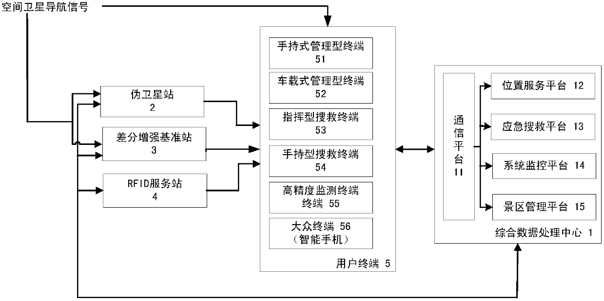
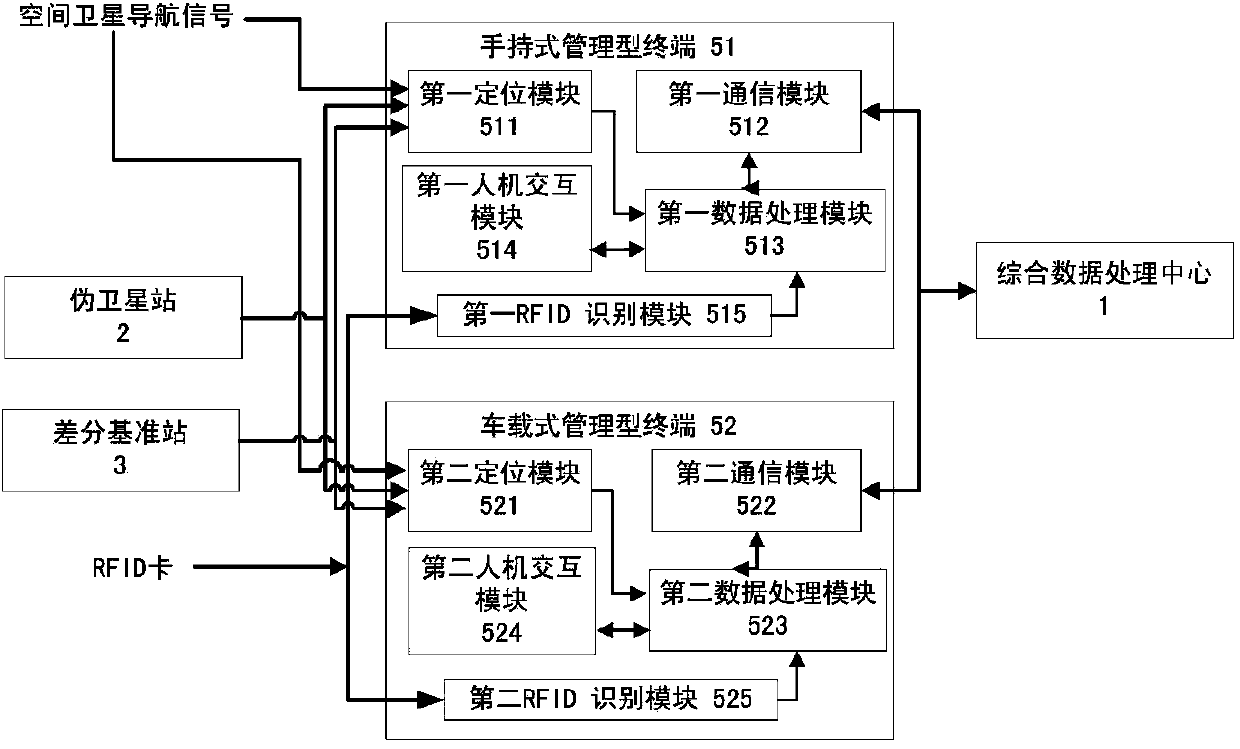
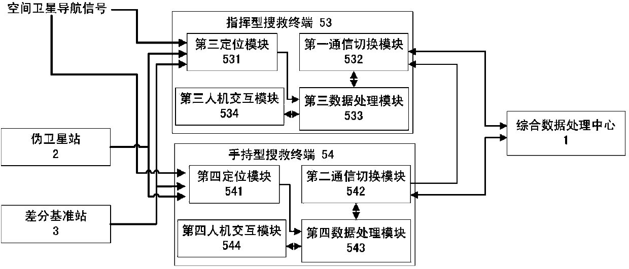
[0020] An intelligent navigation and search and rescue system architecture, including an integrated data processing center 1, a pseudolite station 2, a differential enhanced reference station 3, an RFID service station 4, and a user terminal 5, the embodiment according to figure 1 Make connection lines.

[0021] The integrated data processing center 1 includes a communication platform 11, a location service platform 12, an emergency search and rescue platform 13, a system monitoring platform 14, and a scenic spot management platform 15; the location service platform 12 is responsible for storing and managing the location information of the user terminal 5, and responding to the 1. The location service request proposed by the emergency search and rescue platform 13 and the scenic spot managemen...


PUM


Abstract

The invention discloses an intelligent navigation and search-rescue system architecture which is characterized by combining conventional satellite navigation technology, pseudolite technology, intelligent location-based service technology and modern management technology to form a navigation application service and a search and rescue application service to scenic regions and has the technical characteristics of 'bidirectional performance, team management, information push and remote interaction' and the like. The intelligent navigation and search-rescue system consists of user equipment, location-based service network and a service platform, is combined with the big data based intelligent location-based service technology and has functions capable of being customized according to needs of users.

Description

technical field [0001] The invention relates to an intelligent navigation and search and rescue system architecture in the field of navigation and positioning, which integrates location services, scenic spot management, and emergency search and rescue, and has outstanding technical features such as "two-way, team, information push, and remote interaction". Background technique [0002] Since the "Tenth Five-Year Plan", the country has "mastered satellite navigation and positioning technology, established an independent satellite navigation and positioning system, developed a satellite navigation and positioning application system, and initially established China's satellite navigation and positioning application industry" as the development of my country's satellite navigation and positioning in the past ten years. The goal is listed as a major special item in the "Tenth Five-Year Plan" high-tech industry development plan. In the "National 2010-2020 Science and Technology Dev...

Claims


Application Information

Patent Timeline
IPC IPC(8): G01S19/46H04L29/08H04W84/18
CPCG01S19/46G01S19/03H04W4/02
Inventor 蔚保国李隽王垚王腾崔淼郑迎春申海鹏
Owner NO 54 INST OF CHINA ELECTRONICS SCI & TECH GRP
Learn More