Road segment traffic index estimation system based on unmanned aerial vehicle measurement

A traffic index and UAV technology, which is applied in the traffic control system of road vehicles, traffic control system, traffic flow detection, etc. question

Inactive Publication Date: 2015-01-07
NORTHEAST GASOLINEEUM UNIV
View PDF4 Cites 27 Cited by
  • Summary
  • Abstract
  • Description
  • Claims
  • Application Information

AI Technical Summary

Problems solved by technology

The limited means of calculating road section traffic index in the prior art is only to calculate the traffic index of road section through tens of thousands of taxis in the city returning to the GPS positioning data of the traffic control monitoring platform, but there are following defects in such a calculation method: ( 1) The calculation accuracy is highly dependent on the number of taxis in the road section, but when there are no taxis on the key road section to be calculated, the traffic index of the key road section cannot be calculated; (2) The amount of data transmitted is large, and each taxi Both return GPS positioning data, causing the traffic management and traffic management monitoring platform to bear a huge calculation load

Method used


Image

  • Road segment traffic index estimation system based on unmanned aerial vehicle measurement
  • Road segment traffic index estimation system based on unmanned aerial vehicle measurement

Examples


Embodiment Construction

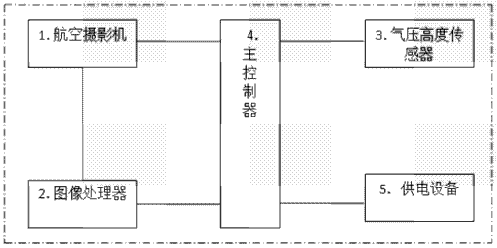
[0016] The implementation of the road segment traffic index estimation system based on UAV measurement will be described in detail below with reference to the accompanying drawings.

[0017] The traffic congestion index is based on the road traffic conditions. Some cities set up a conceptual index value that comprehensively reflects the smoothness or congestion of the road network. It is equivalent to digitizing the congestion situation.

[0018] The minimum time unit for traffic index calculation is 15 minutes. The index value can dynamically reflect the operation status of the entire road network in real time. By defining different statistical periods such as commuting morning and evening peaks or holiday peaks, the average traffic index of peak hours on weekdays, daily traffic An index that reflects the typical traffic characteristics of a day, such as the index maximum. The traffic index is a comprehensive value that integrates the spatial scope, duration, and severity of ...


PUM


Abstract

The invention relates to a road segment traffic index estimation system based on unmanned aerial vehicle measurement. The estimation system is arranged on an unmanned aerial vehicle and comprises an aerial camera, an image processor, a pressure altitude sensor and a main controller, the aerial camera is connected with the image processor, shot road segment images are sent to the image processor to be processed, the main controller is respectively connected with the image processor and the pressure altitude sensor, and a road segment traffic index is estimated according to the image processing result of the image processor and the altitude, detected by the pressure altitude sensor, of the unmanned aerial vehicle. By means of the road segment traffic index estimation system, traffic crowdedness information of key road segments can be provided for road traffic management departments, data are more visual and more accurate, and the road traffic management departments can conveniently develop accurate and effective traffic processing measures.

Description

technical field [0001] The invention relates to the field of unmanned aerial vehicle measurement, in particular to a road segment traffic index estimation system based on unmanned aerial vehicle measurement. Background technique [0002] Unmanned aerial vehicle, or unmanned aircraft, whose English abbreviation is "UAV", is an unmanned aircraft controlled by radio remote control equipment and its own program control device. From a technical point of view, it can be divided into several categories: unmanned helicopters, unmanned fixed-wing aircraft, unmanned multi-rotor aircraft, unmanned airships, and unmanned parawing aircraft. In terms of usage, it can be divided into military drones and civilian drones. For military use, it can be used to complete battlefield reconnaissance and surveillance, positioning and calibration, damage assessment, electronic warfare, and for civilian use, it can be used for border patrol, nuclear radiation detection, aerial photography, aerial pro...

Claims


Application Information

Patent Timeline
Patent Type & Authority Applications(China)
IPC IPC(8): G08G1/01
CPCG08G1/01G08G1/0133G08G1/0175
Inventor 不公告发明人
Owner NORTHEAST GASOLINEEUM UNIV
Why Eureka
Try Eureka