Mobile navigation and positioning system for water information

A navigation and positioning and water conservancy technology, applied in the field of positioning systems, can solve the problems of inconvenient use by water conservancy workers, large amount of water conservancy information data, slow map display speed, etc., and achieve improved spatial query performance, improved display speed, and simple structure Effect

Active Publication Date: 2015-01-14
北京宇图天下科技有限公司
View PDF3 Cites 5 Cited by
  • Summary
  • Abstract
  • Description
  • Claims
  • Application Information

AI Technical Summary

Problems solved by technology

[0003] However, due to the large amount of water conservancy information data, when the existing navigation system is applied to the field of water conservancy information, it has the disadvantages of slow map display speed and slow data query speed, which is inconvenient for water conservancy workers to use

Method used


Image

  • Mobile navigation and positioning system for water information

Examples


Embodiment Construction

[0024] The present invention is described in detail below in conjunction with accompanying drawing:

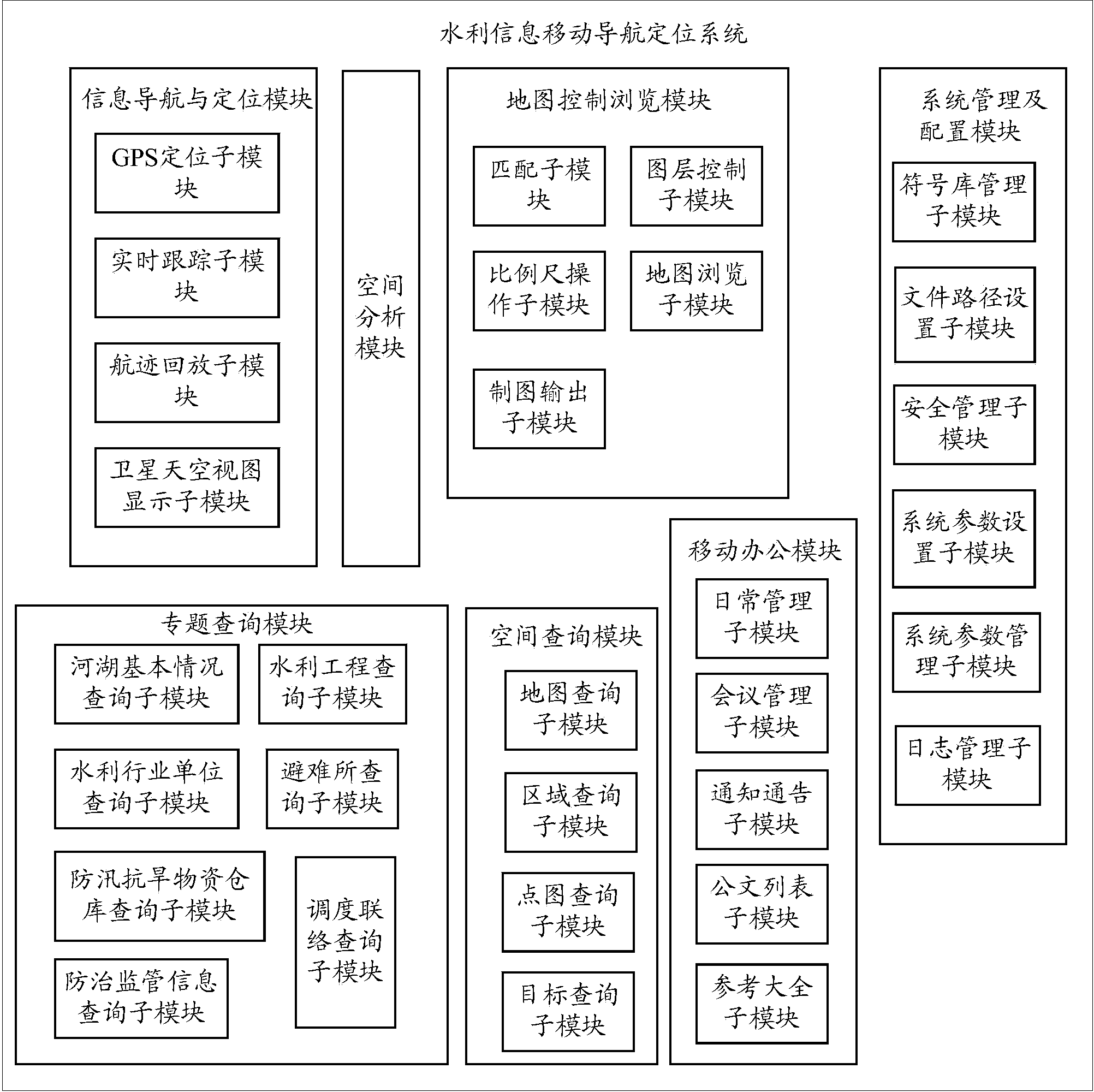
[0025] Such as figure 1 As shown, the present invention provides a mobile navigation and positioning system for water conservancy information, including: an information navigation and positioning module, a spatial analysis module, a map control browsing module, a spatial query module, a special topic query module, a mobile office module, and a system management and configuration module. The functions of each module are described in detail below.

[0026] (1) Information navigation and positioning module

[0027] The information navigation and positioning module includes: GPS positioning sub-module, real-time tracking sub-module, track playback sub-module and satellite sky view display sub-module.

[0028] (1) GPS positioning sub-module

[0029] The GPS positioning sub-module is used to receive the spatial data of the target, and then send the spatial data to the spatial ana...


PUM


Abstract

The invention provides a mobile navigation and positioning system for water information. The mobile navigation and positioning system comprises an information navigation and positioning module, a spatial analysis module, a map control browsing module, a spatial query module, a special query module, a mobile office module, and a system management and configuration module, wherein the information navigation and positioning module comprises a GPS (Global Positioning System) positioning submodule, a real-time tracking submodule, a track playback submodule and a satellite sky view display submodule. By adopting a modular design mode, the system is improved in multiple angles of spatial data storage format, spatial data storage mode and the like, and the system has the advantage that the seeking speed of the water information is high.

Description

technical field [0001] The invention relates to a positioning system, in particular to a water conservancy information mobile navigation and positioning system. Background technique [0002] With the rapid development of computer technology, Global Positioning System (GPS) and Geographic Information System (GIS) have been widely valued and applied in all walks of life. Visualization, integration and integration on GIS can dynamically track targets and display geographic locations on maps in real time. Digital maps are rich in information, intuitive and easy to understand, easy to update, practical and flexible, etc. GIS provides GPS with a visualized original map background, and GPS positioning provides GIS with a new method of collecting data information, and the relationship between the two is getting closer. [0003] However, due to the large amount of water conservancy information data, when the existing navigation system is applied to the field of water conservancy inf...

Claims


Application Information

Patent Timeline
Patent Type & Authority Applications(China)
IPC IPC(8): G06F17/30G01S19/42
CPCG01S19/42G06F16/29
Inventor 孙世友姚新刘海英沈小华孔祥军
Owner 北京宇图天下科技有限公司
Why Eureka
Try Eureka