
Autonomous spacecraft navigation system with combination of astronomical angle measurement and speed measurement, and navigation method of autonomous spacecraft navigation system

An autonomous navigation system and spacecraft technology, applied in the navigation system and its navigation field, can solve the problems of inability to directly obtain speed information and limited accuracy, and achieve the effects of novel methods, simple principles and broad application prospects.

Active Publication Date: 2015-01-21
SHANGHAI SATELLITE ENG INST
View PDF5 Cites 16 Cited by
  • Summary
  • Abstract
  • Description
  • Claims
  • Application Information

AI Technical Summary

Problems solved by technology

However, the speed information of this method cannot be directly obtained, and further position difference or filter estimation is required, and the accuracy is limited.

Method used


Image

  • Autonomous spacecraft navigation system with combination of astronomical angle measurement and speed measurement, and navigation method of autonomous spacecraft navigation system
  • Autonomous spacecraft navigation system with combination of astronomical angle measurement and speed measurement, and navigation method of autonomous spacecraft navigation system
  • Autonomous spacecraft navigation system with combination of astronomical angle measurement and speed measurement, and navigation method of autonomous spacecraft navigation system

Examples


Embodiment Construction

[0019] The present invention will be described in detail below in conjunction with specific embodiments. The following examples will help those skilled in the art to further understand the present invention, but do not limit the present invention in any form. It should be noted that those skilled in the art can make several modifications and improvements without departing from the concept of the present invention. These all belong to the protection scope of the present invention.

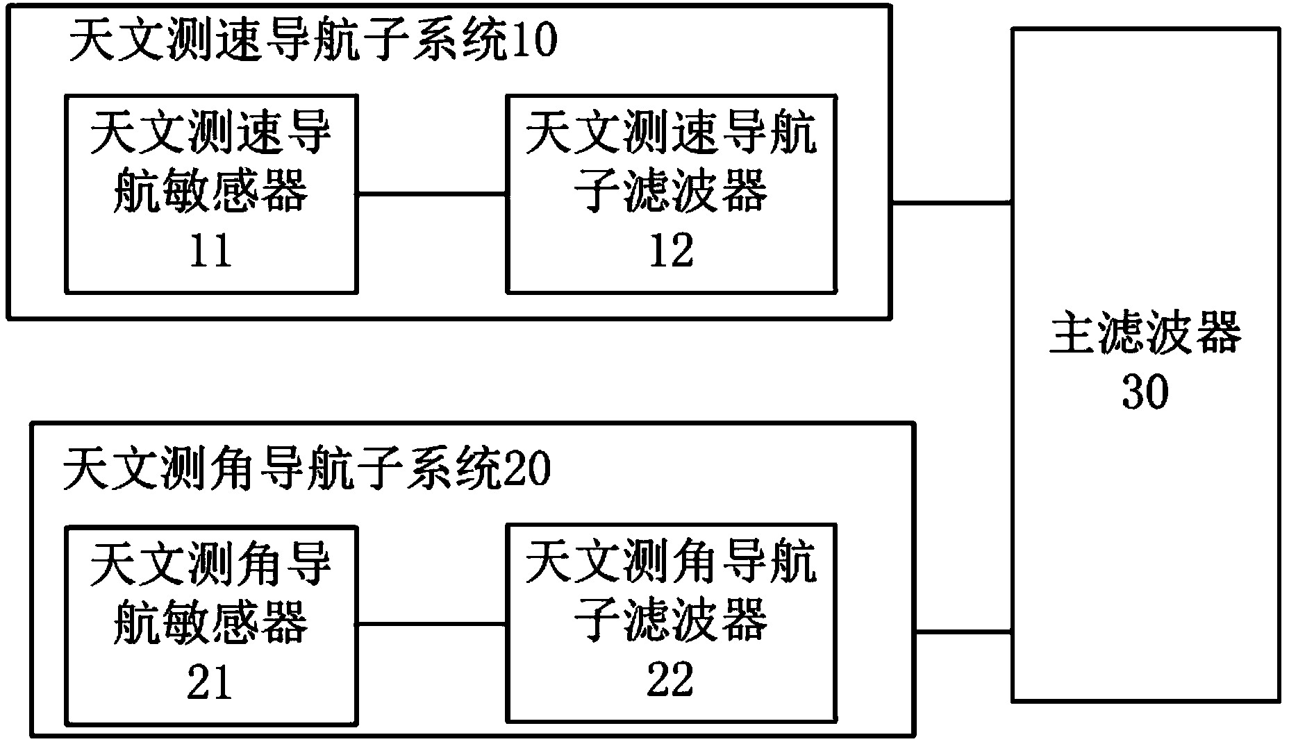
[0020] like figure 1 As shown, the spacecraft astronomical angle measurement and speed measurement combined autonomous navigation system of the present invention includes:

[0021] The astronomical speed measurement and navigation subsystem 10 is connected with the main filter, and is used to observe the navigation celestial body and obtain its spectral frequency shift measurement value, and calculate and output the navigation parameters of the spacecraft in the inertial coordinate system.

[002...


PUM


Abstract

The invention provides an autonomous spacecraft navigation system with combination of astronomical angle measurement and speed measurement, and a navigation method of the autonomous spacecraft navigation system. The navigation system comprises an astronomical speed measurement navigation subsystem, an astronomical angle measurement navigation subsystem and a main filter, wherein the astronomical speed measurement navigation subsystem is connected with the main filter and is used for observing a navigation celestial body, obtaining a spectral frequency shift measurement value of the navigation celestial body and calculating a navigation parameter of the spacecraft under an inertial coordinate system; the astronomical angle measurement navigation subsystem is connected with the main filter and is used for observing the navigation celestial body, obtaining a direction unit vector of the navigation celestial body and calculating the navigation parameter of the spacecraft under the inertial coordinate system; the main filter is connected with the astronomical speed measurement navigation subsystem and the astronomical angle measurement navigation subsystem and is used for obtaining a global optimal estimation value according to the output of the astronomical speed measurement navigation subsystem and the astronomical angle measurement navigation subsystem. By virtue of the autonomous spacecraft navigation system, sight direction angle information and astronomical spectral information of the celestial body are taken as observation quantities; the navigation information is fused by a federated filter manner; the autonomous navigation of the spacecraft in the flight process is achieved; and the high-accuracy estimation of the navigation parameter is achieved.

Description

technical field [0001] The invention relates to a navigation system and a navigation method thereof, in particular to a spacecraft astronomical angle measurement and speed measurement combined autonomous navigation system and a navigation method thereof. Background technique [0002] At present, the commonly used navigation methods include ground radio navigation, optical navigation, inertial navigation and integrated navigation. The development of these navigation methods and technologies has been very mature and widely used in space missions, but they all have their own scope of application and limitations. Especially for deep space exploration, these limitations make the realization of deep space autonomous navigation more difficult. [0003] Astronomical goniometric navigation uses geometric analysis methods or orbital dynamics filtering to calculate the position of the detector by observing information such as the viewing angle of the reference celestial body and the an...

Claims


Application Information

Patent Timeline
Patent Type & Authority Applications(China)
IPC IPC(8): G01C21/24
CPCG01C21/24
Inventor 张伟方宝东陈晓尤伟张嵬
Owner SHANGHAI SATELLITE ENG INST
Learn More